Estuary
| Marine habitats |
|---|
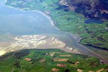 Estuary of the River Nith in Scotland |
An estuary[1] is a partially enclosed coastal body of brackish water with one or more rivers or streams flowing into it, and with a free connection to the open sea.[2]
Estuaries form a transition zone between river environments and maritime environments. They are subject both to marine influences—such as tides, waves, and the influx of saline water—and to riverine influences—such as flows of fresh water and sediment. The inflows of both sea water and fresh water provide high levels of nutrients both in the water column and in sediment, making estuaries among the most productive natural habitats in the world.[3]
Most existing estuaries formed during the Holocene epoch with the flooding of river-eroded or glacially scoured valleys when the sea level began to rise about 10,000–12,000 years ago.[4] Estuaries are typically classified according to their geomorphological features or to water-circulation patterns. They can have many different names, such as bays, harbors, lagoons, inlets, or sounds, although some of these water bodies do not strictly meet the above definition of an estuary and may be fully saline.
The banks of many estuaries are amongst the most heavily populated areas of the world, with about 60% of the world's population living along estuaries and the coast. As a result, many estuaries suffer degradation by many factors, including sedimentation from soil erosion from deforestation, overgrazing, and other poor farming practices; overfishing; drainage and filling of wetlands; eutrophication due to excessive nutrients from sewage and animal wastes; pollutants including heavy metals, polychlorinated biphenyls, radionuclides and hydrocarbons from sewage inputs; and diking or damming for flood control or water diversion.[4]
Definition


The word "estuary" is derived from the Latin word aestuarium meaning tidal inlet of the sea, which in itself is derived from the term aestus, meaning tide. There have been many definitions proposed to describe an estuary. The most widely accepted definition is: "a semi-enclosed coastal body of water, which has a free connection with the open sea, and within sea water is measurably diluted with freshwater derived from land drainage".[2] However, this definition excludes a number of coastal water bodies such as coastal lagoons and brackish seas. A more comprehensive definition of an estuary is "a semi-enclosed body of water connected to the sea as far as the tidal limit or the salt intrusion limit and receiving freshwater runoff; however the freshwater inflow may not be perennial, the connection to the sea may be closed for part of the year and tidal influence may be negligible".[4] This broad definition also includes fjords, lagoons, river mouths, and tidal creeks. An estuary is a dynamic ecosystem with a connection with the open sea through which the sea water enters with the rhythm of the tides. The sea water entering the estuary is diluted by the fresh water flowing from rivers and streams. The pattern of dilution varies between different estuaries and depends on the volume of fresh water, the tidal range, and the extent of evaporation of the water in the estuary.[3]
Classification based on geomorphology
Drowned river valleys
Drowned river valleys also known as coastal plain estuaries. In place where the sea level is rising relative to the land, sea water progressively penetrates into river valleys and the topography of the estuary remains similar to that of a river valley. This is the most common type of estuary in temperate climates. Well-studied estuaries include the Severn Estuary in the United Kingdom and the Ems Dollard along the Dutch-German border.
The width-to-depth ratio of these estuaries is typically large, appearing wedge-shaped (in cross-section) in the inner part and broadening and deepening seaward. Water depths rarely exceed 30 m (100 ft). Examples of this type of estuary in the U.S. are the Hudson River, Chesapeake Bay, and Delaware Bay along the Mid-Atlantic coast, and Galveston Bay and Tampa Bay along the Gulf Coast.[5] San Francisco Bay is another good example of a drowned river valley.
Lagoon-type or bar-built
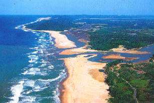
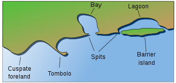
Bar-built estuaries are found in place where the deposition of sediment has kept pace with rising sea level so that the estuaries are shallow and separated from the sea by sand spits or barrier islands. They are partially common in tropical and subtropical locations.
These estuaries are semi-isolated from ocean waters by barrier beaches (barrier islands and barrier spits). Formation of barrier beaches partially encloses the estuary, with only narrow inlets allowing contact with the ocean waters. Bar-built estuaries typically develop on gently sloping plains located along tectonically stable edges of continents and marginal sea coasts. They are extensive along the Atlantic and Gulf coasts of the U.S. in areas with active coastal deposition of sediments and where tidal ranges are less than 4 m (13 ft). The barrier beaches that enclose bar-built estuaries have been developed in several ways:
- building up of offshore bars by wave action, in which sand from the sea floor is deposited in elongated bars parallel to the shoreline,
- reworking of sediment discharge from rivers by wave, current, and wind action into beaches, overwash flats, and dunes,
- engulfment of mainland beach ridges (ridges developed from the erosion of coastal plain sediments around 5000 years ago) due to sea level rise and resulting in the breaching of the ridges and flooding of the coastal lowlands, forming shallow lagoons, and
- elongation of barrier spits from the erosion of headlands due to the action of longshore currents, with the spits growing in the direction of the littoral drift.
Barrier beaches form in shallow water and are generally parallel to the shoreline, resulting in long, narrow estuaries. The average water depth is usually less than 5 m (16 ft), and rarely exceeds 10 m (33 ft). Examples of bar-built estuaries are Barnegat Bay, New Jersey; Laguna Madre,[6] Texas; and Pamlico Sound, North Carolina.
Fjord-type
fjords are formed where pleistocene glaciers deepened and widened existing river valleys so that the become U-shaped in cross sections. At their mouths there are typically rocks bars or sills of glacial deposits, which have the effects of modifying the estuarine circulation.
Fjord-type estuaries are formed in deeply eroded valleys formed by glaciers. These U-shaped estuaries typically have steep sides, rock bottoms, and underwater sills contoured by glacial movement. The estuary is shallowest at its mouth, where terminal glacial moraines or rock bars form sills that restrict water flow. In the upper reaches of the estuary, the depth can exceed 300 m (1,000 ft). The width-to-depth ratio is generally small. In estuaries with very shallow sills, tidal oscillations only affect the water down to the depth of the sill, and the waters deeper than that may remain stagnant for a very long time, so there is only an occasional exchange of the deep water of the estuary with the ocean. If the sill depth is deep, water circulation is less restricted, and there is a slow but steady exchange of water between the estuary and the ocean. Fjord-type estuaries can be found along the coasts of Alaska, the Puget Sound region of western Washington state, British Columbia, eastern Canada, Greenland, Iceland, New Zealand, and Norway.
Tectonically produced
These estuaries are formed by subsidence or land cut off from the ocean by land movement associated with faulting, volcanoes, and landslides. Inundation from eustatic sea level rise during the Holocene Epoch has also contributed to the formation of these estuaries. There are only a small number of tectonically produced estuaries; one example is the San Francisco Bay, which was formed by the crustal movements of the San Andreas fault system causing the inundation of the lower reaches of the Sacramento and San Joaquin rivers.[7]
Classification based on water circulation
Salt wedge
In this type of estuary, river output greatly exceeds marine input and tidal effects have a minor importance. Fresh water floats on top of the seawater in a layer that gradually thins as it moves seaward. The denser seawater moves landward along the bottom of the estuary, forming a wedge-shaped layer that is thinner as it approaches land. As a velocity difference develops between the two layers, shear forces generate internal waves at the interface, mixing the seawater upward with the freshwater. An example of a salt wedge estuary is the Mississippi River.[7]
Partially mixed
As tidal forcing increases, river output becomes less than the marine input. Here, current induced turbulence causes mixing of the whole water column such that salinity varies more longitudinally rather than vertically, leading to a moderately stratified condition. Examples include the Chesapeake Bay and Narragansett Bay.[7]
Well-Mixed
Tidal mixing forces exceed river output, resulting in a well mixed water column and the disappearance of the vertical salinity gradient. The freshwater-seawater boundary is eliminated due to the intense turbulent mixing and eddy effects. The lower reaches of Delaware Bay and the Raritan River in New Jersey are examples of vertically homogenous estuaries.[7]
Inverse
Inverse estuaries occur in dry climates where evaporation greatly exceeds the inflow of fresh water. A salinity maximum zone is formed, and both riverine and oceanic water flow close to the surface towards this zone.[8] This water is pushed downward and spreads along the bottom in both the seaward and landward direction.[4] An example of an inverse estuary is Spencer Gulf, South Australia.
Intermittent
Estuary type varies dramatically depending on freshwater input, and is capable of changing from a wholly marine embayment to any of the other estuary types.[9][10]
Physiochemical variation
The most important variable characteristics of estuary water are the concentration of dissolved oxygen, salinity and sediment load. There is extreme spatial variability in salinity, with a range of near zero at the tidal limit of tributary rivers to 3.4% at the estuary mouth. At any one point the salinity will vary considerably over time and seasons, making it a harsh environment for organisms. Sediment often settles in intertidal mudflats which are extremely difficult to colonize. No points of attachment exist for algae, so vegetation based habitat is not established. Sediment can also clog feeding and respiratory structures of species, and special adaptations exist within mudflat species to cope with this problem. Lastly, dissolved oxygen variation can cause problems for life forms. Nutrient-rich sediment from man-made sources can promote primary production life cycles, perhaps leading to eventual decay removing the dissolved oxygen from the water; thus hypoxic or anoxic zones can develop.[11]
Implications for marine life
Estuaries provide habitats for a large number of organisms and support very high productivity. Estuaries provide habitats for many fish nurseries, depending upon their locations in the world, such as salmon and sea trout.[12] Also, migratory bird populations, such as the black-tailed godwit,[13] make essential use of estuaries.
Two of the main challenges of estuarine life are the variability in salinity and sedimentation. Many species of fish and invertebrates have various methods to control or conform to the shifts in salt concentrations and are termed osmoconformers and osmoregulators. Many animals also burrow to avoid predation and to live in the more stable sedimental environment. However, large numbers of bacteria are found within the sediment which have a very high oxygen demand. This reduces the levels of oxygen within the sediment often resulting in partially anoxic conditions, which can be further exacerbated by limited water flux.
Phytoplankton are key primary producers in estuaries. They move with the water bodies and can be flushed in and out with the tides. Their productivity is largely dependent upon the turbidity of the water. The main phytoplankton present are diatoms and dinoflagellates which are abundant in the sediment.
It is important to remember that a primary source of food for many organisms on estuaries, including bacteria, is detritus from the settlement of the sedimentation.
Human impact
Of the thirty-two largest cities in the world, twenty-two are located on estuaries.[14] For example, New York City is located at the mouth of the Hudson River estuary.[15]
As ecosystems, estuaries are under threat from human activities such as pollution and overfishing. They are also threatened by sewage, coastal settlement, land clearance and much more. Estuaries are affected by events far upstream, and concentrate materials such as pollutants and sediments.[16] Land run-off and industrial, agricultural, and domestic waste enter rivers and are discharged into estuaries. Contaminants can be introduced which do not disintegrate rapidly in the marine environment, such as plastics, pesticides, furans, dioxins, phenols and heavy metals.
Such toxins can accumulate in the tissues of many species of aquatic life in a process called bioaccumulation. They also accumulate in benthic environments, such as estuaries and bay muds: a geological record of human activities of the last century.
For example, Chinese and Russian industrial pollution, such as phenols and heavy metals, has devastated fish stocks in the Amur River and damaged its estuary soil.[17]
Estuaries tend to be naturally eutrophic because land runoff discharges nutrients into estuaries. With human activities, land run-off also now includes the many chemicals used as fertilizers in agriculture as well as waste from livestock and humans. Excess oxygen-depleting chemicals in the water can lead to hypoxia and the creation of dead zones.[18] This can result in reductions in water quality, fish, and other animal populations.
Overfishing also occurs. Chesapeake Bay once had a flourishing oyster population that has been almost wiped out by overfishing. Oysters filter these pollutants, and either eat them or shape them into small packets that are deposited on the bottom where they are harmless. Historically the oysters filtered the estuary's entire water volume of excess nutrients every three or four days. Today that process takes almost a year,[19] and sediment, nutrients, and algae can cause problems in local waters.
Notable examples
North America
- Chesapeake Bay including Hampton Roads
- Columbia River Estuary
- Delaware Bay
- Drake's Estero
- Great Bay
- Gulf of Saint Lawrence
- Laguna Madre
- Lake Borgne
- Lake Merritt
- Lake Pontchartrain
- Long Island Sound
- Mobile Bay
- Narragansett Bay
- New York-New Jersey Harbor
- Puget Sound
- Pamlico Sound
- San Francisco Bay
- Tampa Bay
South America
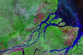
- Amazon River
- Iguape-Cananéia-Paranaguá estuary lagoon complex
- Lagoa dos Patos and Lagoon Mirim
- Rio de la Plata
Europe
Africa
- Orange Estuary (Gariep)
Asia
- Ganges Delta including the Sundarbans
- Gulf of Ob
- Yenisei Gulf
Oceania
- Gippsland Lakes
- Port Jackson (Sydney Harbour)
- Spencer Gulf
See also
- Bay mud
- Coastal and Estuarine Research Federation
- Estuarine acidification
- Estuarine fish
- Firth
- Freshwater inflow
- Liman
- List of estuaries of England
- List of estuaries of South Africa
- List of waterways
- National Estuarine Research Reserve
- Region of freshwater influence
- River delta
- Shell growth in estuaries
- Tidal bore
- Tidal prism
- Wetland
References
- ↑ UK pronunciation: /ˈɛstjʊr.i/, /ˈɛstʃʊr.i/, /ˈɛstju.ᵊri/.
US pronunciation: /ˈɛstʃu.ɛri/, /ˈɛstju.ɛri/.
Sources: • Wells, John C. (2008), Longman Pronunciation Dictionary (3rd ed.), Longman, p. 283, ISBN 9781405881180
• Roach, Peter (2011), Cambridge English Pronouncing Dictionary (18th ed.), Cambridge: Cambridge University Press, ISBN 9780521152532 - 1 2 Pritchard, D. W. (1967). "What is an estuary: physical viewpoint". In Lauf, G. H. Estuaries. A.A.A.S. Publ. 83. Washington, DC. pp. 3–5.
- 1 2 McLusky, D. S.; Elliott, M. (2004). The Estuarine Ecosystem: Ecology, Threats and Management. New York: Oxford University Press. ISBN 0-19-852508-7.
- 1 2 3 4 Wolanski, E. (2007). Estuarine Ecohydrology. Amsterdam: Elsevier. ISBN 978-0-444-53066-0.
- ↑ Kunneke, J. T.; Palik, T. F. (1984). "Tampa Bay environmental atlas" (PDF). U.S. Fish Wildl. Serv. Biol. Rep. 85 (15): 3. Retrieved January 12, 2010.
- ↑ 1393960326
- 1 2 3 4 Kennish, M. J. (1986). Ecology of Estuaries. Volume I: Physical and Chemical Aspects. Boca Raton, FL: CRC Press. ISBN 0-8493-5892-2.
- ↑ Wolanski, E. (1986). "An evaporation-driven salinity maximum zone in Australian tropical estuaries". Estuarine, Coastal, and Shelf Science. 22 (4): 415–424. Bibcode:1986ECSS...22..415W. doi:10.1016/0272-7714(86)90065-X.
- ↑ Tomczak, M. (2000). "Oceanography Notes Ch. 12: Estuaries". Retrieved 30 November 2006.
- ↑ Day, J. H. (1981). Estuarine Ecology. Rotterdam: A. A. Balkema. ISBN 90-6191-205-9.
- ↑ Kaiser; et al. (2005). Marine Ecology. Processes, Systems and Impacts. New York: Oxford University Press. ISBN 019924975X.
- ↑ Gillanders, Bronwyn M. (2003). "Evidence of connectivity between juvenile and adult habitats for mobile marine fauna: an important component of nurseries" (PDF). Marine Ecology Progress Series.
- ↑ Gill, Jennifer A. (2001). "The buffer effect and large-scale population regulation in migratory birds". Nature. 412 (6845): 436–438. doi:10.1038/35086568.
- ↑ Ross, D. A. (1995). Introduction to Oceanography. New York: Harper Collins College Publishers. ISBN 978-0-673-46938-0.
- ↑ "Estuaries tutorial". NOAA. Retrieved March 25, 2008.
- ↑ Branch, G. (1999). "Estuarine vulnerability and ecological impacts: Estuaries of South Africa, edited by Brian R. Allanson and Dan Baird". Trends in Ecology & Evolution. 14 (12): 499. doi:10.1016/S0169-5347(99)01732-2.
- ↑ "Indigenous Peoples of the Russian North, Siberia and Far East: Nivkh" by Arctic Network for the Support of the Indigenous Peoples of the Russian Arctic
- ↑ Gerlach (1981). Marine Pollution. Berlin: Springer. ISBN 0387109404.
- ↑ "Oyster Reefs: Ecological importance". US National Oceanic and Atmospheric Administration. Archived from the original on October 3, 2008. Retrieved 2008-01-16.
External links
| Wikimedia Commons has media related to Estuaries. |
| Look up estuary in Wiktionary, the free dictionary. |
- Animated documentary on Chesapeake Bay NOAA.
- "Habitats: Estuaries – Characteristics". www.onr.navy.mil. Retrieved 2009-11-17.
- The Estuary Guide (Based on experience and R&D within the UK)
| Landforms |
|   |
|---|---|---|
| Beaches | ||
| Processes |
| |
| Management | ||
| Related | ||
| ||