Vosges (department)
| Vosges | |||
|---|---|---|---|
| Department | |||
| |||
 Location of Vosges in France | |||
| Coordinates: 48°10′N 06°25′E / 48.167°N 6.417°ECoordinates: 48°10′N 06°25′E / 48.167°N 6.417°E | |||
| Country | France | ||
| Region | Grand Est | ||
| Prefecture | Épinal | ||
| Subprefectures |
Neufchâteau Saint-Dié-des-Vosges | ||
| Government | |||
| • President of the General Council | Christian Poncelet | ||
| Area1 | |||
| • Total | 5,874 km2 (2,268 sq mi) | ||
| Population (2013) | |||
| • Total | 375,226 | ||
| • Rank | 64th | ||
| • Density | 64/km2 (170/sq mi) | ||
| Time zone | CET (UTC+1) | ||
| • Summer (DST) | CEST (UTC+2) | ||
| Department number | 88 | ||
| Arrondissements | 3 | ||
| Cantons | 17 | ||
| Communes | 510 | ||
| ^1 French Land Register data, which exclude estuaries, and lakes, ponds, and glaciers larger than 1 km2 | |||
| Part of the series on |
| Lorraine |
|---|
 Flag of Lorraine since the 13th century |
|
|
Administrative divisions
|
|
Lorraine in the EU |
|
Related topics |
|
Vosges (French pronunciation: [voʒ]) is a department in the east of France, named after the Vosges Mountains. The department consists of 17 cantons and 515 communes (villages or towns) of which 242 are rural.[1] It contains the hometown of Joan of Arc, Domrémy.[2]
History
Hundred Years' War
Joan of Arc was born in Domrémy, a village which was then in the French part of the duchy of Bar, or Barrois mouvant, located West of the Meuse River, while the rest of the duchy (East of the Meuse) was part of the Holy Roman Empire. The duchy of Bar was later incorporated to the province of Lorraine and the village of Domrémy renamed Domrémy-la-Pucelle, in honor of Joan of Arc.[3]
French revolution
The Vosges department is one of the original 83 departments of France, created on February 9, 1790 during the French Revolution.[4] It was made of territories that had been part of the province of Lorraine. In German it is referred to as Vogesen.
In 1793 the independent principality of Salm-Salm (town of Senones and its surroundings), enclosed inside the Vosges department, was annexed to France and incorporated into Vosges. In 1795 the area of Schirmeck was detached from the Bas-Rhin department and incorporated into the Vosges department.[5] The Vosges department had now an area of 6,127 km² (2,366 sq. miles) which it kept until 1871.
In 1794 the Vosges was the site of a major battle between the forces of Revolutionary France and the Allied Coalition. See Battle of the Vosges.
The Place des Vosges in Paris was so renamed in 1799 when the department became the first to pay the new Revolutionary taxes.
Franco-Prussian War
After the French defeat in the Franco-Prussian War of 1870–1871, 4% of the Vosges department in the extreme northeast of the department was annexed to the German Empire by the Treaty of Frankfurt on the ground that the people there spoke Germanic dialects. The area annexed on May 18, 1871 corresponded to the canton of Schirmeck and the northern half of the canton of Saales. Schirmeck and Saales had been historically part of Alsace. These territories, along with the rest of Alsace and the annexed territories of Lorraine, became part of the Reichsland of Elsaß-Lothringen. The area of the Vosges department was thus reduced to its current 5,874 km² (2,268 sq. miles).
First and Second World Wars
In 1919, with the allied victory in the World War I, Alsace-Lorraine was returned to France by Germany at the Treaty of Versailles. However, Schirmeck and Saales were not returned to the Vosges department, but instead were incorporated into the recreated Bas-Rhin department.
An ill-fated Special Air Service (SAS) mission called Operation Loyton took place in the Vosges forests in 1944.
Various military cemeteries are located in the department the largest of which is the Le Quéquement American Cemetery in Dinozé, near Epinal. It was built by the American 45th Infantry Division in September 1944 and completed in 1959. 5,255 soldiers killed in action during fighting in France, the Vosges, the Rhine valley and Germany are interred there.[6]
Geography
The largest cities/towns are Épinal (approx. 33,000), Saint-Dié-des-Vosges (approx. 21,500), Gérardmer (approx. 8,500) and Remiremont (approx. 8,000). A total population of 378,830 inhabitants was recorded in the 2011 census. The population is split with 70% in urban areas and 30% living in rural districts.
Roughly 47% of the department is covered by woodlands and forests (the third highest in France), while 38% of land is in agricultural use. The remaining 13% is commercial, industrial and residential.[1]
While the west part of the Vosges is flat sedimentary land (well suited for mineral waters), the east is dominated by the Vosges Mountain range (including the Ballons des Vosges Regional Nature Reserve) of which the Grand Ballon at 1424m is the highest peak.[1]
The River Saône rises (named after the Celtic goddess Sagon)[7] at Vioménil, in the Vosges. The Anger river also passes through it.
Culture
The Roman fortified town of Grand, located 30 km from Toul, has an amphitheatre and a temple to the Cult of Apollo. At La Bure, located a few kilometres from Saint-Dié-des-Vosges, archaeologists have found evidence for human habitation going back to around 2000 BC.
Miscellaneous topics
Séré de Rivières forts
As a border area, the Vosges region was a route for possible invasion. As such four important forts were constructed in the department: Bourlémont Fort in Mont-les-Neufchâteau (built between 1878 and 1881); Uxegney Fort (built between 1882 and 1884); Bois l'Abbé Fort (built in 1884 and 1885); and the Le Parmont Fort in Remiremont (built between 1874 and 1876).[6]
Tourism
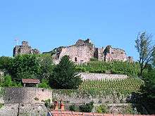 Fort of Epinal
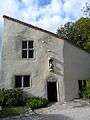 Birth house of Joan of Arc in Domrémy-la-Pucelle
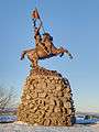 Statue of Joan of Arc erected in 1909 at the former border with Alsace-Lorraine
 The Vosges mountains near La Bresse
See also
- Cantons of the Vosges department
- Communes of the Vosges department
- Arrondissements of the Vosges department
References
- 1 2 3 "The Vosges Departmental Tourist Board - The département: a few figures". Tourismevosges.fr. Retrieved 2012-09-22.
- ↑ "Jeanne d'arc Domremy-la-Pucelle Centre Johannique, Centre d'Interprétation Vosges". Tourismevosges.fr. Retrieved 2012-09-22.
- ↑ Condemnation trial, p. 37.. Retrieved 23 March 2006.
- ↑ "Vosges tourisme > Histoire". Site officiel du Conseil général des Vosges (in French). Retrieved 23 July 2009.
- ↑ P.S. (2002). "L'Essor, Revue trimestrielle de Schirmeck" (PDF). Le Pays lorrain (in French). Société d'archéologie lorraine et du Musée historique lorrain. 83: 255. ISSN 0031-3394. Retrieved 3 August 2009.
- 1 2 "The Vosges Departmental Tourist Board - Forts and cemeteries". Tourismevosges.fr. Retrieved 2012-09-22.
- ↑ "The Vosges Departmental Tourist Board - Archeological sites". Tourismevosges.fr. Retrieved 2012-09-22.
External links
- (French) Vosges.com Economic information about the Vosges
- Climbbybike.com: All information on and profiles of the climbs and cols of the Vosges
- (French) General Council website
- (French) Prefecture website
- (French) Vosges vacations
- (English) Information - Vosges.us
- Illustrated Article on the Vosges Battlefields in Winter at 'Battlefields Europe'
-
 "Vosges (France)". Encyclopædia Britannica (11th ed.). 1911.
 - "Vosges". Collier's New Encyclopedia. 1921.