Luccombe, Somerset

Coordinates: 51°11′22″N 3°33′33″W / 51.1895°N 3.5593°W
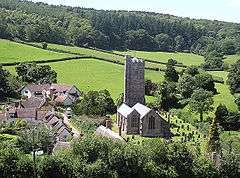
Luccombe or Luckham is a village and civil parish in the Exmoor National Park in the English county of Somerset. It at the foot of the moor's highest hill, the 1,750 feet (533 m) Dunkery Beacon, and is about one mile south of the A39 road between Porlock and Minehead. Administratively it forms part of the district of West Somerset. The parish includes the hamlets of Stoke Pero (Stoche in 1086 Domesday Book) and Horner.
History
The name Luccombe is believed to mean either Lufa's valley or valley where the counting was done.[2] Locumbe in 1086 Domesday book.
There is evidence of Iron age field systems on the top of Great Hill,[3] and the Sweetworthy Iron Age hill fort.
At the time of the Domesday Book in 1086 East Luccombe was held by Ralph de Limesy passing by the 13th century to the Luccombe family, and later to the Arundell family. Along with West Luccombe these passed to the Acland family
Luccombe was part of the hundred of Carhampton.[4]
In 1944 Sir Richard Acland gave the Holnicote Estate, which includes Luccombe, to the National Trust.
Luccombe is the location of the annual St Albans Cathedral Choir Camp, which celebrated its 50th anniversary in 2008.
Horner
Horner is on the eastern bank of Horner Water on which there is a restored, but non-working, water mill and which is crossed by a packhorse bridge, and on the route of the Coleridge Way. Horner is also home to two tearooms which boast a loyal patronage and also a campsite field owned by the scouting association. Burrowhayes Farm is a nearby campsite that shares its patronage with the tearooms.
Stoke Pero
Stoke Pero was an ancient parish in the hundred of Carhampton. In the Domesday Book it was mentioned as Stoche. It became a civil parish in 1866, but in 1933 the parish was abolished and absorbed into the parish of Luccombe.[5]
Governance
The parish council has responsibility for local issues, including setting an annual precept (local rate) to cover the council’s operating costs and producing annual accounts for public scrutiny. The parish council evaluates local planning applications and works with the local police, district council officers, and neighbourhood watch groups on matters of crime, security, and traffic. The parish council's role also includes initiating projects for the maintenance and repair of parish facilities, as well as consulting with the district council on the maintenance, repair, and improvement of highways, drainage, footpaths, public transport, and street cleaning. Conservation matters (including trees and listed buildings) and environmental issues are also the responsibility of the council.
The village falls within the Non-metropolitan district of West Somerset, which was formed on 1 April 1974 under the Local Government Act 1972, having previously been part of Williton Rural District.[6] The district council is responsible for local planning and building control, local roads, council housing, environmental health, markets and fairs, refuse collection and recycling, cemeteries and crematoria, leisure services, parks, and tourism.
Somerset County Council is responsible for running the largest and most expensive local services such as education, social services, libraries, main roads, public transport, policing and fire services, trading standards, waste disposal and strategic planning.
As Luccombe falls within the Exmoor National Park some functions normally administered by district or county councils have, since 1997, fallen under the Exmoor National Park Authority, which is known as a ‘single purpose’ authority, which aims to "conserve and enhance the natural beauty, wildlife and cultural heritage of the National Parks" and "promote opportunities for the understanding and enjoyment of the special qualities of the Parks by the public",[7] including responsibility for the conservation of the historic environment.[8]
It is also part of the Bridgwater and West Somerset county constituency represented in the House of Commons of the Parliament of the United Kingdom. It elects one Member of Parliament (MP) by the first past the post system of election, and part of the South West England constituency of the European Parliament which elects seven MEPs using the d'Hondt method of party-list proportional representation.
Landmarks
There are two medieval packhorse bridges.[9] One is known as Hacketty Way Bridge,[10] which is 50 inches (1,300 mm) wide and has a span of 18 feet (5.5 m).[11] The other at West Luccombe has a shallow pointed arch. The cobbled roadway is 39 inches (990 mm) wide and has a span of 15 feet (4.6 m).[12]
Religious sites
The parish Church of St Mary has a chancel dating from about 1300, with the nave and tower being added around 1450. In l530 the aisle was added, and in 1752–1756 a gallery added which was removed in 1840 when the church was further restored and the vestry added. It has been designated as a grade I listed building.[13]
Stoke Pero Church has a 13th-century tower.[14]
References
- ↑ "Statistics for Wards, LSOAs and Parishes — SUMMARY Profiles" (Excel). Somerset Intelligence. Retrieved 4 January 2014.
- ↑ Bush, Robin (1994). Somerset: The complete guide. Wimborne: The Dovecote Press Ltd. p. 133. ISBN 1-874336-26-1.
- ↑ Havinden, Michael (1981). The Somerset Landscape. The Making of the English Landscape. London: Hodder and Stoughton. p. 54. ISBN 0-340-20116-9.
- ↑ "Carhampton Hundred". Domesday Map. Retrieved 23 September 2011.
- ↑ Vision of Britain website
- ↑ "Williton RD". A vision of Britain Through Time. University of Portsmouth. Retrieved 5 January 2014.
- ↑ "The Authority". Exmoor National Park. Retrieved 29 November 2007.
- ↑ "Exmoor National Park NMP". English Heritage. Retrieved 29 November 2007.
- ↑ "Packhorse Bridge at NGR SS 8987 4608". Images of England. English Heritage. Retrieved 24 January 2009.
- ↑ "Hacketty Way Bridge". Images of England. English Heritage. Retrieved 24 January 2009.
- ↑ Hinchliffe, Ernest (1994). Guide to the Packhorse Bridges of England. Cicerone. p. 150. ISBN 978-1852841430.
- ↑ Hinchliffe, Ernest (1994). Guide to the Packhorse Bridges of England. Cicerone. p. 153. ISBN 978-1852841430.
- ↑ "Church of St Mary". Images of England. English Heritage. Retrieved 24 January 2009.
- ↑ "Stoke Pero Church". Images of England. English Heritage. Retrieved 24 January 2009.
External links
| Wikimedia Commons has media related to Luccombe, Somerset. |
