Stringston

Coordinates: 51°10′32″N 3°10′40″W / 51.1756°N 3.1778°WStringston is a village and civil parish on the northern edge of the Quantock Hills in the English county of Somerset. The village is 10 miles (16 km) west of Bridgwater, and close to the villages of Holford, Kilve and Stogursey. In 2002, the parish was estimated to have a population of 116.[1]
Besides the village of Stringston itself, the parish includes the settlements of Lilstock and Kilton. Administratively, the civil parish falls within the West Somerset local government district within the Somerset shire county, with administrative tasks shared between county, district and parish councils.[2]
History
The name of the village means Strenge's settlement and was part of the Acland-Hood estate.[3]
Kilton and Lilstock were separate ancient parishes, part of the Williton and Freemanners Hundred.[4] Kilton took its name from Kilve Hill. It was first mentioned in 873, when King Alfred gave his estate at Kilton to his son Edward the Elder under his will.[5] Kilton became a civil parish in 1866, but in 1886 was combined with Lilstock to form the civil parish of Kilton cum Lilstock, itself abolished in 1933 and absorbed into Stringston.[6]
Governance
The parish council has responsibility for local issues, including setting an annual precept (local rate) to cover the council’s operating costs and producing annual accounts for public scrutiny. The parish council evaluates local planning applications and works with the local police, district council officers, and neighbourhood watch groups on matters of crime, security, and traffic. The parish council's role also includes initiating projects for the maintenance and repair of parish facilities, as well as consulting with the district council on the maintenance, repair, and improvement of highways, drainage, footpaths, public transport, and street cleaning. Conservation matters (including trees and listed buildings) and environmental issues are also the responsibility of the council.
The village falls within the Non-metropolitan district of West Somerset, which was formed on 1 April 1974 under the Local Government Act 1972, having previously been part of Williton Rural District.[7] The district council is responsible for local planning and building control, local roads, council housing, environmental health, markets and fairs, refuse collection and recycling, cemeteries and crematoria, leisure services, parks, and tourism.
Somerset County Council is responsible for running the largest and most expensive local services such as education, social services, libraries, main roads, public transport, policing and fire services, trading standards, waste disposal and strategic planning.
It is also part of the Bridgwater and West Somerset county constituency represented in the House of Commons of the Parliament of the United Kingdom. It elects one Member of Parliament (MP) by the first past the post system of election, and part of the South West England constituency of the European Parliament which elects seven MEPs using the d'Hondt method of party-list proportional representation.
Religious sites
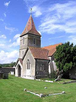
The Church of St Mary dates from the 17th century and has been designated by English Heritage as a Grade II listed building.[8] Within the churchyard is a cross dating from the 14th century,[9] which is on the Heritage at Risk register.[10]
The Church of St. Nicholas in Kilton has a 14th-century chancel, with the lower stages of the tower and nave being added in the late 15th or early 16th century.[11]
References
- 1 2 "Parish Population Statistics". ONS Census 2001. Somerset County Council. Archived from the original on 21 November 2009. Retrieved 13 December 2009.
- ↑ "West Somerset" (PDF). Parish Population Estimates for 2002. Somerset County Council. Retrieved 8 October 2008.
- ↑ Bush, Robin (1994). Somerset: The Complete Guide. Dovecote Press. p. 201. ISBN 1-874336-26-1.
- ↑ "Somerset Hundreds". GENUKI. Retrieved 23 October 2011.
- ↑ R.W. Dunning (editor), A.P. Baggs, R.J.E. Bush, M.C. Siraut (1985). "Parishes: Kilton". Victoria County History. A History of the County of Somerset: Volume 5. Institute of Historical Research. Retrieved 3 December 2014.
- ↑ Vision of Britain website
- ↑ A Vision of Britain Through Time : Williton Rural District
- ↑ "Church of St Mary". Images of England. Retrieved 6 January 2008.
- ↑ "Churchyard Cross". Images of England. Retrieved 6 January 2008.
- ↑ "Stringston churchyard cross, Stringston - West Somerset". Heritage at Risk. English Heritage. Retrieved 20 October 2013.
- ↑ "Church of St. Nicholas". Images of England. English Heritage. Retrieved 8 February 2009.
External links
| Wikimedia Commons has media related to Stringston. |
