Clatworthy
| Clatworthy | |
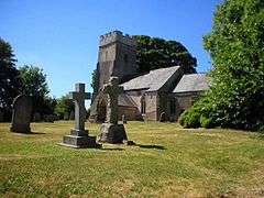 Church of St Mary Magdalene |
|
 Clatworthy |
|
| Population | 101 (2001)[1] |
|---|---|
| OS grid reference | ST052309 |
| District | West Somerset |
| Shire county | Somerset |
| Region | South West |
| Country | England |
| Sovereign state | United Kingdom |
| Post town | TAUNTON |
| Postcode district | TA4 |
| Dialling code | 01984 |
| Police | Avon and Somerset |
| Fire | Devon and Somerset |
| Ambulance | South Western |
| EU Parliament | South West England |
| UK Parliament | Bridgwater and West Somerset |
Coordinates: 51°04′11″N 3°21′12″W / 51.0697°N 3.3532°W
Clatworthy is a village and civil parish in the West Somerset District of Somerset, England. It is situated 10 miles (16 km) from Wellington and four miles (6 km) from Wiveliscombe on the southern slopes of the Brendon Hills and close to the Exmoor National Park.
The Clatworthy Reservoir is run by Wessex Water and has a capacity of 5,364,000 cubic metres,[2] supplying some 200,000 homes. It impounds the head waters of the River Tone and the surrounding area is used for walking and fishing.
History
The name of the village means the "homestead where burdock grows".[3]
The parish of Clatworthy was part of the Williton and Freemanners Hundred.[4]
Just west of the village, at the edge of Exmoor National Park, is the Clatworthy Reservoir, which impounds the headwaters of River Tone and supplies water to some 200,000 homes and businesses, some as far away as Yeovil. An iron age enclosure known as Clatworthy Castle was sited on the wooded slopes above the reservoir and there are round barrows in the north of the parish.[3]
Governance
The parish council has responsibility for local issues, including setting an annual precept (local rate) to cover the council’s operating costs and producing annual accounts for public scrutiny. The parish council evaluates local planning applications and works with the local police, district council officers, and neighbourhood watch groups on matters of crime, security, and traffic. The parish council's role also includes initiating projects for the maintenance and repair of parish facilities, as well as consulting with the district council on the maintenance, repair, and improvement of highways, drainage, footpaths, public transport, and street cleaning. Conservation matters (including trees and listed buildings) and environmental issues are also the responsibility of the council.

The village falls within the Non-metropolitan district of West Somerset, which was formed on 1 April 1974 under the Local Government Act 1972, having previously been part of Williton Rural District.[5] The district council is responsible for local planning and building control, local roads, council housing, environmental health, markets and fairs, refuse collection and recycling, cemeteries and crematoria, leisure services, parks, and tourism.
Somerset County Council is responsible for running the largest and most expensive local services such as education, social services, libraries, main roads, public transport, policing and fire services, trading standards, waste disposal and strategic planning.
It is also part of the Bridgwater and West Somerset represented in the House of Commons of the Parliament of the United Kingdom. It elects one Member of Parliament (MP) by the first past the post system of election, and part of the South West England constituency of the European Parliament which elects seven MEPs using the d'Hondt method of party-list proportional representation.
Religious sites
The parish Church of St Mary Magdalene has a 12th-century tower. The nave was rebuilt in 1872, while the chancel was rebuilt and the tower altered between 1860 and 1883.[6]
References
- ↑ "Parish Population Statistics" (PDF). ONS Census 2001. Somerset County Council. Archived from the original (PDF) on 21 November 2009. Retrieved 2008-07-03.
- ↑ "Hydrological Summary for the United Kingdom" (PDF). The Centre for Ecology & Hydrology. Retrieved 2009-01-10.
- 1 2 Bush, Robin (1994). Somerset: The complete guide. Wimborne, Dorset: Dovecote Press. p. 68. ISBN 1-874336-26-1.
- ↑ "Somerset Hundreds". GENUKI. Retrieved 23 October 2011.
- ↑ A Vision of Britain Through Time : Williton Rural District
- ↑ "Church of St Mary Magdalene". Images of England. English Heritage. Retrieved 2008-12-14.
External links
![]() Media related to Clatworthy at Wikimedia Commons
Media related to Clatworthy at Wikimedia Commons
