Interstate 605
| ||||
|---|---|---|---|---|
| San Gabriel River Freeway | ||||
 | ||||
| Route information | ||||
| Defined by Streets and Highways Code § 619 | ||||
| Maintained by Caltrans | ||||
| Length: | 27.40 mi[1] (44.10 km) | |||
| History: | 1940s as a state highway, 1964 as a number[2] | |||
| Major junctions | ||||
| South end: |
| |||
|
| ||||
| North end: |
| |||
| Highway system | ||||
| ||||
.svg.png)
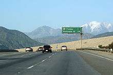
Interstate 605 (abbreviated I-605, officially known as the San Gabriel River Freeway and colloquially referred to as the 605 (the six-oh-five)) is a major north–south Interstate Highway in the Greater Los Angeles Area of Southern California. It is about 27 miles (43 km) in length, and runs from Seal Beach to Irwindale, closely paralleling the San Gabriel River for most of its alignment. The San Gabriel River Freeway is one of the few Southern California freeways not named after a city along its route.
This route is part of the California Freeway and Expressway System.[3]
Route description
The California Streets and Highways Code defines Route 605 as "(a) Route 1 near Seal Beach to Route 405. (b) Route 405 to Route 210 near Duarte." However, the portion in subsection A has yet to be constructed.
The southern terminus of I-605 is at the San Diego (I-405) and Garden Grove (State Route 22) Freeways in Seal Beach. From there, it runs roughly north through the Gateway Cities of the Los Angeles Basin. It then shifts north-northeast, crossing the Whittier Narrows and across the San Gabriel Valley. I-605 then ends at its junction with the Foothill Freeway, (I-210) in Duarte, a small city located at the foothills of the San Gabriel Mountains.
I-605 follows most of the length of the San Gabriel River from the San Diego Freeway in Seal Beach to the Santa Fe Dam. Typically dry riverbed and flood basins are visible from many portions of the route, especially near the northern terminus. Also, the freeway features an HOV lane for carpools of two or more people throughout most of the route. The left shoulder is close to non-existent. The road also suffers from traffic jams regularly, especially near I-5 (the Santa Ana Freeway).
Signs along I-605's entrances and freeway junctions do not include destinations (control cities) such as "Seal Beach" or "Irwindale", but simply read "NORTH" or "SOUTH". In place of control cities, a simple "THRU TRAFFIC" designation is used on signs along I-605 itself.
Route 605 from Route 405 to Route 10 is known as the San Gabriel River Freeway, as named by Senate Bill 99, Chapter 1101 in 1967.[4]
- Other names
- The I-605/I-105 interchange is known as the Joe A. Gonsalves Memorial Interchange, as named by Assembly Bill 96, Chapter 129 in 2001. Gonsalves became the first person of Portuguese ancestry to become a member of the California State Legislature in 1962[5]
Transportation
Metro Express line 577 runs through Interstate 605 between Interstate 10 and Interstate 405. The Green Line serves the Norwalk Station at the interchange of the eastern terminus of Interstate 105. Foothill Transit Commuter Express Lines 493, 495, and 497 use Interstate 605 from the Interstate 10 interchange to continue their routes to the Pomona Freeway to destinations in City of Industry, Diamond Bar, and Chino.
History
In 1957, the number for this route was proposed as I-13, as it is positioned approximately midway between I-5 and I-15 (although it intersects the former). That number was rejected, as was the second proposed number, I-102. Finally, the designation I-605 was accepted in 1958.[6]
Interstate 605 began construction in 1963 and the first section was opened in 1964 from Interstate 405 to Pomona Freeway CA 60. The newest section (extension to Interstate 210) was opened in 1971 was originally signed as SR 243. There are plans to extend it to SR 1 further south in Orange County, but strong community opposition means that it is unlikely that the alignment will ever be built.[6]
Exit list
| County | Location | mi[7] | km | Exit[7] | Destinations | Notes |
|---|---|---|---|---|---|---|
| Orange | Seal Beach | 0.00 | 0.00 | 1A | South end of I-605; SR 22 exit 2 | |
| 0.41 | 0.66 | 1B | Former SR 7 south; I-405 north/SR 22 west exit 24 | |||
| 0.41 | 0.66 | 1C | Signed as exit 1A northbound; former SR 7 north; I-405 south exit 24A | |||
| Los Alamitos | 1.41 | 2.27 | 1D | Katella Avenue – Los Alamitos | Signed as exit 1B northbound | |
| 1.69 | 2.72 | 2A | Willow Street | Signed as exit 1B northbound | ||
| Los Angeles | Long Beach | 1.93 | 3.11 | 2B | Spring Street, Cerritos Avenue | Southbound exit and northbound entrance |
| 3.38 | 5.44 | 3 | Carson Street, Lincoln Avenue – Hawaiian Gardens | Former US 91 and SR 18 | ||
| Cerritos | 4.51 | 7.26 | 5A | Del Amo Boulevard – Lakewood | ||
| 5.39 | 8.67 | 5B | South Street | |||
| 6.69 | 10.77 | 7A | ||||
| Norwalk | 7.45 | 11.99 | 7B | Alondra Boulevard | ||
| 8.50 | 13.68 | 9A | Rosecrans Avenue | |||
| 9.29 | 14.95 | 9B | I-105 east exits 18A-B | |||
| 9.29 | 14.95 | 9C | Imperial Highway | Signed as exit 9B southbound | ||
| 9.53 | 15.34 | 10 | Firestone Boulevard | Former SR 42 | ||
| Santa Fe Springs | 11.25 | 18.11 | 11 | Florence Avenue – Downey | ||
| 11.25 | 18.11 | 11 | Former US 101 Bypass south; I-5 exit 124 | |||
| 11.89 | 19.14 | 12 | Telegraph Road – Santa Fe Springs | Former US 101 Bypass north, Former SR 26 | ||
| 13.18 | 21.21 | 13 | Slauson Avenue | |||
| 13.69 | 22.03 | 14 | Washington Boulevard – Pico Rivera | Signed as exits 14A (west) and 14B (east) southbound | ||
| Whittier | 15.21 | 24.48 | 15 | Former US 101 | ||
| Pico Rivera | 16.05 | 25.83 | 16 | Beverly Boulevard | Southbound exit to Beverly Boulevard west is via exit 17 | |
| 17.21 | 27.70 | 17 | Rose Hills Road | |||
| Industry | 18.29 | 29.43 | 18 | Peck Road | ||
| 19.05 | 30.66 | 19 | SR 60 exit 12 | |||
| 21.03 | 33.84 | 21 | Valley Boulevard – Industry | Former US 60 / SR 212 | ||
| Baldwin Park | 21.83 | 35.13 | 22 | Former US 99 / US 70 / US 60; I-10 east exits 31A-B, south exit 31A | ||
| 22.71 | 36.55 | 23 | Ramona Boulevard – Baldwin Park, El Monte | Former US 99 | ||
| Irwindale | 23.79 | 38.29 | 24 | Lower Azusa Road, Los Angeles Street | ||
| 25.16 | 40.49 | 25 | Live Oak Avenue – Irwindale | Northbound exit and southbound entrance | ||
| 26.60 | 42.81 | 26 | Arrow Highway | Southbound exit and northbound entrance | ||
| 27.40 | 44.10 | 27 | Signed as exits 27A (east) and 27B (west); no exit number southbound; I-210 east exit 36A, west exit 36B | |||
| Duarte | 27.54 | 44.32 | 27C | Huntington Drive – Duarte | At-grade intersection; former US 66; north end of I-605 | |
| 1.000 mi = 1.609 km; 1.000 km = 0.621 mi | ||||||
See also
-
 California Roads portal
 -
 Greater Los Angeles portal
References
- ↑ "Route Log and Finder List - Interstate System: Table 2". FHWA. Retrieved October 7, 2007.
- ↑ "Los Angeles Highways". Scvresources.com. Retrieved January 26, 2013.
- ↑ "CA Codes (shc:250-257)". Leginfo.ca.gov. Retrieved January 26, 2013.
- ↑ 2007 Named Freeways, Highways, Structures and Other Appurtenances in California (PDF). Caltrans. p. 62. Retrieved March 28, 2007.
- ↑ Ibid. 97, 185
- 1 2 Faigin, Daniel. "Interstate 605". California Highways. Retrieved September 23, 2016.
- 1 2 Warring, KS (April 18, 2008 by). "Interstate 605 Freeway Interchanges" (PDF). California Numbered Exit Uniform System. California Department of Transportation. Retrieved September 1, 2014. Check date values in:
|date=(help)
| Wikimedia Commons has media related to Interstate 605 (California). |
| ||
