Harrisonville, Illinois
| Harrisonville | |
| Unincorporated community | |
| Name origin: William Henry Harrison | |
| Country | United States |
|---|---|
| State | Illinois |
| County | Monroe |
| Precinct | 15 |
| Elevation | 397 ft (121 m) |
| Coordinates | 38°16′39″N 90°21′00″W / 38.27750°N 90.35000°WCoordinates: 38°16′39″N 90°21′00″W / 38.27750°N 90.35000°W |
| Timezone | CST (UTC-6) |
| - summer (DST) | CDT (UTC-5) |
| Postal code | 62295 |
| Area code | 618 |
  Location of Harrisonville within Illinois | |
Harrisonville is an unincorporated community in the historic Harrisonville Precinct of Monroe County, Illinois.
History
Harrisonville was the first county seat of Monroe County, and was originally called Carthage, or even earlier, in 1786, as Brashear's Fort. The name was changed by an act of the territorial assembly, in 1816, to honor William Henry Harrison, who actually owned several tracts of land in the area, mostly in Moredock precinct. However, sources suggest the name was already in common usage by 1810 or even earlier. The original site, some distance west of its current location has been swallowed up by the Mississippi River, completely obiterated by 1860. It was an important shipping point on the Mississippi River, lying on the bank directly opposite Herculaneum, Missouri and drawing on the agricultural production of the American Bottom.[1]
References
- ↑ Combined History of Randolph, Monroe and Perry Counties, Illinois, J. L. McDonough & Co., Philadelphia, 1883 (Google Ebook)
| Counties | 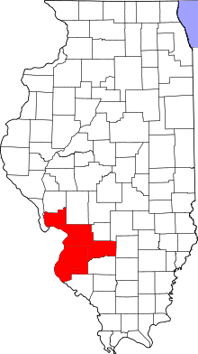 | |
|---|---|---|
| Major Cities (25,000+) | ||
| Cities (5,000-25,000) | ||
| Villages and Towns (1,000-5,000) |
| |
| Interstates in the Metro-East | ||
| Airports/Military Bases | ||
| List of Colleges in the Metro-East | ||
| Sports teams based in the Metro East |
| |
Municipalities and communities of Monroe County, Illinois, United States | ||
|---|---|---|
| Cities | ||
| Villages | ||
| Unincorporated communities | ||
| Footnotes | ‡This populated place also has portions in an adjacent county or counties | |