Monroe County, Illinois
| Monroe County, Illinois | |
|---|---|
 Monroe County Courthouse, Waterloo | |
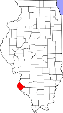 Location in the U.S. state of Illinois | |
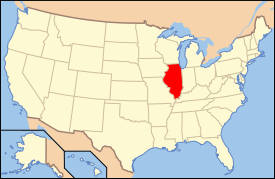 Illinois's location in the U.S. | |
| Founded | 1816 |
| Named for | James Monroe |
| Seat | Waterloo |
| Largest city | Waterloo |
| Area | |
| • Total | 398 sq mi (1,031 km2) |
| • Land | 385 sq mi (997 km2) |
| • Water | 13 sq mi (34 km2), 3.3% |
| Population | |
| • (2010) | 32,957 |
| • Density | 86/sq mi (33/km²) |
| Congressional district | 12th |
| Time zone | Central: UTC-6/-5 |
| Website |
www |
Monroe County is a county located in the U.S. state of Illinois. According to the 2010 census, it had a population of 32,957.[1] Its county seat and largest city is Waterloo.[2]
Monroe County is included in the St. Louis, MO-IL Metropolitan Statistical Area. It is located in the southern portion of Illinois known locally as "Little Egypt".
History
Indigenous peoples lived along the Mississippi River and related waterways for thousands of years before European contact. French Jesuit priests in the Illinois Country encountered the Kaskaskia and Cahokia, bands of the Illiniwek confederacy.
The first European settlement in this area was St. Philippe, founded in 1723 by Philippe François Renault, a French courtier, on his concession about three miles north of Fort de Chartres along the Mississippi River. This early agricultural community quickly produced a surplus, and grains were sold to the lower Louisiana colony for years. They were integral to that community's survival, as its climate did not allow cultivation of such staple grains.
After the American Revolution, Monroe County was formed in 1816 out of Randolph and St. Clair counties, as the 8th county created from the then Illinois Territory.
Beginning on the Mississippi River where the base line, which is about three-fourths of a mile below Judge Briggs's present residence, strikes the said river; thence with the base line until it strikes the first township line therefrom; thence southeast to the southeast corner of township two south, range nine west; thence south to the southeast corner of township four north, range nine west; thence southwestwardly to the Mississippi, so as to include Alexander McNabb's farm, and thence up the Mississippi to the beginning shall constitute a separate county, to be called MONROE.
Illinois Territorial Laws 1815-16, p. 25[3]
It was named in honor of James Monroe,[4] who had just served as United States Secretary of War and who was elected President later that same year. Its first county seat was Harrisonville, named for William Henry Harrison, former governor of the Northwest Territory and future President. Harrison invested in several tracts of land in the American Bottoms above Harrisonville, mostly in the present precinct of Moredock, ownership of which he retained until his death.[5]
Waterloo was designated as the mantle of county seat in 1825. The sites of the colonial towns of St. Philippe and Harrisonville were submerged by the Mississippi River, in flooding caused by deforestation of river banks during the steamboat years. Crews cut so many trees that banks destabilized and collapsed in the current, making the river wider and more shallow from St. Louis to the confluence with the Ohio River. This change caused more severe flooding, as well as lateral channel changes, such as the one that cut off the village of Kaskaskia from the Illinois mainland.[6]
An unincorporated community of Harrisonville was re-established east of the original site. The bounds of Monroe County in 1816 did not include Precincts 1 and 6 (village of Hecker and Prairie du Long), Precinct 1 and most of 6 was added in 1825 from St. Clair County.[7] The strip of Precinct 6 from the survey township line east to the Kaskaskia was added, once again from St. Clair, two years later in 1827.[8] Some minor adjustments and clarifications of the boundaries have taken place, but the borders have remained essentially static since 1827.
 Monroe County from the time of its creation to 1825
 Monroe County between 1825 and 1827
 In 1827, an adjustment to Monroe County's border with St. Clair brought it to its present territory
Geography
According to the U.S. Census Bureau, the county has a total area of 398 square miles (1,030 km2), of which 385 square miles (1,000 km2) is land and 13 square miles (34 km2) (3.3%) is water.[9]
The western part of the county on the Mississippi River is part of the American Bottom floodplain, while the eastern portion of the county is relatively flat and was originally prairie. The transition zone between has high bluffs of limestone and dolomite and has distinctive Karst topography with numerous sinkholes, caves, and springs.
Climate and weather
| Waterloo, Illinois | ||||||||||||||||||||||||||||||||||||||||||||||||||||||||||||
|---|---|---|---|---|---|---|---|---|---|---|---|---|---|---|---|---|---|---|---|---|---|---|---|---|---|---|---|---|---|---|---|---|---|---|---|---|---|---|---|---|---|---|---|---|---|---|---|---|---|---|---|---|---|---|---|---|---|---|---|---|
| Climate chart (explanation) | ||||||||||||||||||||||||||||||||||||||||||||||||||||||||||||
| ||||||||||||||||||||||||||||||||||||||||||||||||||||||||||||
| ||||||||||||||||||||||||||||||||||||||||||||||||||||||||||||
In recent years, average temperatures in the county seat of Waterloo have ranged from a low of 20 °F (−7 °C) in January to a high of 89 °F (32 °C) in July, although a record low of −18 °F (−28 °C) was recorded in December 1989 and a record high of 107 °F (42 °C) was recorded in August 1962. Average monthly precipitation ranged from 2.32 inches (59 mm) in January to 4.25 inches (108 mm) in July.[10]
Major highways
Adjacent counties
- St. Clair County - northeast
- Randolph County - southeast
- Ste. Genevieve County, Missouri - south
- Jefferson County, Missouri - west
- St. Louis County, Missouri - northwest
Demographics
| Historical population | |||
|---|---|---|---|
| Census | Pop. | %± | |
| 1820 | 1,537 | — | |
| 1830 | 2,000 | 30.1% | |
| 1840 | 4,481 | 124.1% | |
| 1850 | 7,679 | 71.4% | |
| 1860 | 12,832 | 67.1% | |
| 1870 | 12,982 | 1.2% | |
| 1880 | 13,682 | 5.4% | |
| 1890 | 12,948 | −5.4% | |
| 1900 | 13,847 | 6.9% | |
| 1910 | 13,508 | −2.4% | |
| 1920 | 12,839 | −5.0% | |
| 1930 | 12,369 | −3.7% | |
| 1940 | 12,754 | 3.1% | |
| 1950 | 13,282 | 4.1% | |
| 1960 | 15,507 | 16.8% | |
| 1970 | 18,831 | 21.4% | |
| 1980 | 20,117 | 6.8% | |
| 1990 | 22,422 | 11.5% | |
| 2000 | 27,619 | 23.2% | |
| 2010 | 32,957 | 19.3% | |
| Est. 2015 | 33,879 | [11] | 2.8% |
| U.S. Decennial Census[12] 1790-1960[13] 1900-1990[14] 1990-2000[15] 2010-2013[1] | |||
As of the 2010 United States Census, there were 32,957 people, 12,589 households, and 9,375 families residing in the county.[16] The population density was 85.6 inhabitants per square mile (33.1/km2). There were 13,392 housing units at an average density of 34.8 per square mile (13.4/km2).[9] The racial makeup of the county was 98.0% white, 0.4% Asian, 0.2% American Indian, 0.2% black or African American, 0.3% from other races, and 0.8% from two or more races. Those of Hispanic or Latino origin made up 1.4% of the population.[16] In terms of ancestry, 53.9% were German, 16.5% were Irish, 9.6% were English, and 6.2% were American.[17]
Of the 12,589 households, 34.7% had children under the age of 18 living with them, 62.9% were married couples living together, 7.9% had a female householder with no husband present, 25.5% were non-families, and 21.5% of all households were made up of individuals. The average household size was 2.59 and the average family size was 3.02. The median age was 41.0 years.[16]
The median income for a household in the county was $68,253 and the median income for a family was $80,832. Males had a median income of $55,988 versus $39,375 for females. The per capita income for the county was $31,091. About 3.5% of families and 4.5% of the population were below the poverty line, including 4.3% of those under age 18 and 2.4% of those age 65 or over.[18]
Transportation
Highways
- Interstate 255 From Jefferson Barracks Bridge and Missouri east to Route 3 north of Columbia, then north toward Dupo
- Provides access to the Interstate System, South Saint Louis County via the J.B. bridge as well as Downtown St. Louis and western St. Clair County
- Illinois Route 3 From Interstate 255 and Dupo south southeast through Columbia and Waterloo on turning west toward Red Bud
- Main north-south corridor and the backbone of Monroe County
- Illinois Route 156 From western terminus at Valmeyer east through Waterloo to Hecker and on toward New Athens
- Also called the Valmeyer highway or Hecker highway, west and east of Waterloo, respectively, it runs from the bluffs of the Mississippi to the Kaskaskia
- Illinois Route 158 From western terminus south of Columbia at Route 3, east northeast toward Millstadt
- The area's main link with central and eastern St. Clair County for those not near Hecker
- Illinois Route 159 From southern terminus in Red Bud at Route 3, north through Prairie du Long to Hecker and on toward Smithton
- Significant eastern north-south corridor, provides alternate routes, and primary north-south link for Prairie Du Long and Hecker
County roads
- Bluff Road
- runs along the bluffs from Palmer Rd. northwest of Columbia, through old Valmeyer and Chalfin Bridge, past Fults to Prairie du Rocher in Randolph County
- Maeystown Road
- runs from Illinois Route 3 in Waterloo (as Lakeview Drive) through Wartburg and Maeystown to Bluff Rd. at Chalfin Bridge
- Kaskaskia Road
- historic route from Kaskaskia to St. Louis, leaves Illinois Route 3 south of Waterloo, passes through Burksville and St. Joe, descends into the Bottoms outside Renault, crosses Bluff Rd. and railroad tracks to Stringtown Rd.
- Hanover Road
- Runs from Route 3 west, past New Hanover down the Fountain Gap to Bluff Rd. at Miles Rd. and B Rd.. Marks approximate future border between Columbia and Waterloo.
- HH Road
- Runs from Gilmore Lakes Rd., north of Floraville Rd., west across Route 3 in Waterloo (as Country Club Ln.) to Bluff Rd. east of Fountain
- KK Road
- Runs from the Mississippi River levee opposite Crystal City, Missouri, west across Bluff Rd. up the bluffs at Monroe City, through Madonnaville, across Maeystown Rd., through Burksville and Burksville Station, across Route 3 to J Rd. south of Route 156
Public Transportation
- There is a regular MetroBus express bus, 502X Waterloo-Columbia, running from Waterloo, through Columbia, to the MetroLink station in East St. Louis.
Rivers
- Mississippi River
- Bridges and ferries
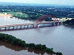
- Jefferson Barracks Bridge - crosses the Mississippi northwest of Columbia, carries Interstate 255
- Access
- none
- Kaskaskia River
- Bridges and ferries
- none
- Access
- none
The closest access to and bridges over the Kaskaskia are downriver at Baldwin in Randolph County and upriver at New Athens in St. Clair County. South of Monroe County, there is a ferry across the Mississippi in Randolph County, providing access to Ste. Genevieve, Missouri and Pere Marquette State Park, and a bridge at Chester.
Rail
While the railroad played a large part in the history and development of the county, the main line through the county, running along Illinois Route 3, has been abandoned and removed. However, Union Pacific tracks run through the Bottoms from the intermodal yard at Dupo in St. Clair County, running roughly parallel to Bluff Rd. which crosses them several times, through old Valmeyer and Fults on past Prairie du Rocher in Randolph County. The tracks are still in use, but carry only freight, and have no stops in Monroe County.
Aviation
There is a small airfield in the Bottoms west of Columbia called Sackman Field.
Communities
Cities
Villages
Unincorporated communities
Precincts
For census and election purposes, Monroe County is currently divided into 26 numbered precincts (1-27, for some reason there is no Precinct 14). However, for geographical, genealogical, and historic purposes the older, named precincts are of greater utility.
- Bluff Precinct
- named for the ubiqitous limestone cliffs it sits atop and which run along its western bounds.
- Columbia Precinct
- formerly Eagle Precinct from the original French name for their settlement, L'Aigle
- Harrisonville Precinct
- honors William Henry Harrison who also gave his name to a settlement
- Mitchie Precinct
- so named for the Mitchegamie Indians who at one time inhabited the extreme southern part of the county
- Moredock Precinct
- after John Moredock, territorial legislator, and Major commanding a battalion in the War of 1812
- New Design Precinct
- named after the settlement began by James Lemen, a confidante of Thomas Jefferson, in 1786
- New Hanover Precinct
- as with the settlement, its name recalls Hanover, Germany, hometown of the settlements founder
- Prairie Du Long Precinct
- from hybrid French/English "Long Prairie", it was added in 1825, after the county's genesis, the strip along the river in 1827.
- Renault Precinct
- also a settlement, for Philip Francois Renault of the French Company of the Indies, an early exploiter of the area
- Waterloo Precinct
- formerly Fountain Precinct, from Fountain Creek which runs though it on its way to the bluffs and down to the river
See also
- Fountain Creek Bridge
- Illinois Caverns State Natural Area
- Kaskaskia River State Fish and Wildlife Area
- National Register of Historic Places listings in Monroe County
References
- 1 2 "State & County QuickFacts". United States Census Bureau. Retrieved July 7, 2014.
- ↑ "Find a County". National Association of Counties. Retrieved 2011-06-07.
- ↑ Counties of Illinois, p. 32-33. With Twenty-three Maps Showing the Original and the Present Boundary Lines of Each County of the State, Retrieved on January 22, 2008.
- ↑ Gannett, Henry (1905). The Origin of Certain Place Names in the United States. U.S. Government Printing Office. p. 212.
- ↑ Combined History of Randolph, Monroe and Perry Counties, Illinois, J. L. McDonough & Co., Philadelphia, 1883
- ↑ F. Terry Norris, "Where Did the Villages Go? Steamboats, Deforestation, and Archaeological Loss in the Mississippi Valley", in Common Fields: An Environmental History of St. Louis, Andrew Hurley, ed., St. Louis, MO: Missouri Historical Society Press, 1997, pp. 73-89
- ↑ "Counties of Illinois pg. 46-47". 1825 Retrieved on January 22, 2008.
- ↑ "Counties of Illinois, pg. 49-50". 1827 Retrieved on January 22, 2008.
- 1 2 "Population, Housing Units, Area, and Density: 2010 - County". United States Census Bureau. Retrieved 2015-07-12.
- 1 2 "Monthly Averages for Waterloo, Illinois". The Weather Channel. Retrieved 2011-01-27.
- ↑ "County Totals Dataset: Population, Population Change and Estimated Components of Population Change: April 1, 2010 to July 1, 2015". Retrieved July 2, 2016.
- ↑ "U.S. Decennial Census". United States Census Bureau. Retrieved July 7, 2014.
- ↑ "Historical Census Browser". University of Virginia Library. Retrieved July 7, 2014.
- ↑ "Population of Counties by Decennial Census: 1900 to 1990". United States Census Bureau. Retrieved July 7, 2014.
- ↑ "Census 2000 PHC-T-4. Ranking Tables for Counties: 1990 and 2000" (PDF). United States Census Bureau. Retrieved July 7, 2014.
- 1 2 3 "DP-1 Profile of General Population and Housing Characteristics: 2010 Demographic Profile Data". United States Census Bureau. Retrieved 2015-07-12.
- ↑ "DP02 SELECTED SOCIAL CHARACTERISTICS IN THE UNITED STATES – 2006-2010 American Community Survey 5-Year Estimates". United States Census Bureau. Retrieved 2015-07-12.
- ↑ "DP03 SELECTED ECONOMIC CHARACTERISTICS – 2006-2010 American Community Survey 5-Year Estimates". United States Census Bureau. Retrieved 2015-07-12.
External links
 |
St. Louis County, Missouri | St. Clair County | | |
| Jefferson County, Missouri | |
|||
| ||||
| | ||||
| Ste. Genevieve County, Missouri | Randolph County |
Municipalities and communities of Monroe County, Illinois, United States | ||
|---|---|---|
| Cities | ||
| Villages | ||
| Unincorporated communities | ||
| Footnotes | ‡This populated place also has portions in an adjacent county or counties | |
| Counties |  | |
|---|---|---|
| Major Cities (25,000+) | ||
| Cities (5,000-25,000) | ||
| Villages and Towns (1,000-5,000) |
| |
| Interstates in the Metro-East | ||
| Airports/Military Bases | ||
| List of Colleges in the Metro-East | ||
| Sports teams based in the Metro East |
| |
| Topics | 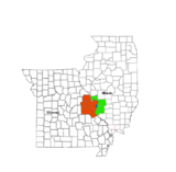 | |
|---|---|---|
| Central city | ||
| Largest cities (over 50,000 in 2010) | ||
| Medium-sized cities (over 20,000 in 2010) | ||
| Largest towns and villages (over 10,000 in 2010) |
| |
| Missouri Counties | ||
| Illinois Counties | ||
| Subregions | ||
| Counties | 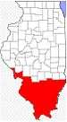 | |
|---|---|---|
| Mid-sized cities (25,000+) | ||
| Small Cities (10,000-25,000) | ||
| Small Cities (5,000-10,000) | ||
| Interstates | ||
| Airports/Military bases |
| |
| Universities | ||
| Colleges | ||
| Sports teams based in the Southern Illinois | ||
Coordinates: 38°17′N 90°11′W / 38.28°N 90.18°W