Chaflin Bridge, Illinois
| Chaflin Bridge | |
| unincorporated community | |
| Name origin: Isaac Chaflin, early settler | |
| Country | United States |
|---|---|
| State | Illinois |
| County | Monroe |
| Precinct | 15 |
| Elevation | 400 ft (122 m) |
| Coordinates | 38°12′43″N 90°16′07″W / 38.21194°N 90.26861°WCoordinates: 38°12′43″N 90°16′07″W / 38.21194°N 90.26861°W |
| Government | unincorporated community |
| Timezone | CST (UTC-6) |
| - summer (DST) | CDT (UTC-5) |
| Postal code | 62244 |
| Area code | 618 |
  Location of Chaflin Bridge within Illinois
| |
Chaflin Bridge is an unincorporated community in the historic Mitchie Precinct of Monroe County, Illinois, United States. It lies on the old Bluff Road in the American Bottoms between Fults and the old site of Valmeyer and near Maeystown.
History
It was settled in 1796 by Isaac Chaflin and his son William, who arrived in the area from England, via Pennsylvania. Another son, James, was massacred along with his entire family when they were forced to stop for provisions while on their way to the area, travelling up the Mississippi from its confluence with the Ohio at Cairo, which was the main route for those moving west from the Appalachians.[1]
References
- ↑ Combined History of Randolph, Monroe and Perry Counties, Illinois, J. L. McDonough & Co., Philadelphia, 1883
| Counties | 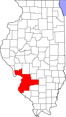 | |
|---|---|---|
| Major Cities (25,000+) | ||
| Cities (5,000-25,000) | ||
| Villages and Towns (1,000-5,000) |
| |
| Interstates in the Metro-East | ||
| Airports/Military Bases | ||
| List of Colleges in the Metro-East | ||
| Sports teams based in the Metro East |
| |
Municipalities and communities of Monroe County, Illinois, United States | ||
|---|---|---|
| Cities | ||
| Villages | ||
| Unincorporated communities | ||
| Footnotes | ‡This populated place also has portions in an adjacent county or counties | |
This article is issued from Wikipedia - version of the 9/4/2016. The text is available under the Creative Commons Attribution/Share Alike but additional terms may apply for the media files.