Grahamtown, Maryland
| Grahamtown, Maryland | |
|---|---|
| Census-designated place | |
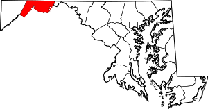
  Location within the state of Maryland | |
| Coordinates: 39°38′46″N 78°55′19″W / 39.64611°N 78.92194°WCoordinates: 39°38′46″N 78°55′19″W / 39.64611°N 78.92194°W | |
| Country | United States |
| State | Maryland |
| County | Allegany |
| Area | |
| • Total | 0.2 sq mi (0.4 km2) |
| • Land | 0.2 sq mi (0.4 km2) |
| • Water | 0 sq mi (0 km2) |
| Elevation | 1,880 ft (570 m) |
| Population (2010) | |
| • Total | 364 |
| • Density | 2,518/sq mi (972.3/km2) |
| Time zone | Eastern (EST) (UTC-5) |
| • Summer (DST) | EDT (UTC-4) |
| FIPS code | 24-34425 |
| GNIS feature ID | 2583634 |
Grahamtown is an unincorporated community and census-designated place (CDP) in Allegany County, Maryland, United States, located at the southeast edge of Frostburg. As of the 2010 census it had a population of 364.[1] It is part of the Cumberland, MD-WV Metropolitan Statistical Area.
The town takes its name from Curtin Graham, who owned a farmhouse at this site, surrounded by several small service buildings in the 1880s. A fire gutted the farmhouse in 1995, leaving only an uninhabited shell. Grahamtown is also known as Wright's Crossing, marking the point where Maryland Route 36 crosses Welsh Hill.[2]
References
- ↑ "Geographic Identifiers: 2010 Demographic Profile Data (G001): Grahamtown CDP, Maryland". U.S. Census Bureau, American Factfinder. Retrieved May 24, 2013.
- ↑ Connie Beachy (1999). "Grahamtown & Wright's Crossing". Ancestry.com.
This article is issued from Wikipedia - version of the 10/29/2016. The text is available under the Creative Commons Attribution/Share Alike but additional terms may apply for the media files.