Rawlings, Maryland
| Rawlings, Maryland | |
|---|---|
| Census-designated place | |
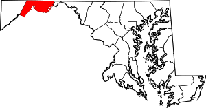
  Location within the state of Maryland | |
| Coordinates: 39°32′4″N 78°53′0″W / 39.53444°N 78.88333°WCoordinates: 39°32′4″N 78°53′0″W / 39.53444°N 78.88333°W | |
| Country | United States |
| State | Maryland |
| County | Allegany |
| Area | |
| • Total | 0.9 sq mi (2.3 km2) |
| • Land | 0.9 sq mi (2.3 km2) |
| • Water | 0 sq mi (0 km2) |
| Elevation | 750 ft (230 m) |
| Population (2010) | |
| • Total | 693 |
| • Density | 777/sq mi (300.0/km2) |
| Time zone | Eastern (EST) (UTC-5) |
| • Summer (DST) | EDT (UTC-4) |
| ZIP codes | 21557 |
| FIPS code | 24-65150 |
| GNIS feature ID | 2583680 |
Rawlings is an unincorporated community and census-designated place (CDP) in Allegany County, Maryland, United States, on the McMullen Highway (U.S. Route 220). As of the 2010 census, the Rawlings CDP had a population of 693.[1]
The community was named for Moses Rawlings, an officer in the Revolutionary War.[2] It was originally known as "Rawlings Station" after a post office was established on the railroad there on March 7, 1856.
References
- ↑ "Geographic Identifiers: 2010 Demographic Profile Data (G001): Rawlings CDP, Maryland". U.S. Census Bureau, American Factfinder. Retrieved May 29, 2013.
- ↑ Federal Writers' Project (1940). Maryland, a Guide to the Old Line State. WPA. p. 517. ISBN 978-1-62376-019-9.
This article is issued from Wikipedia - version of the 10/31/2016. The text is available under the Creative Commons Attribution/Share Alike but additional terms may apply for the media files.