Carlos, Maryland
| Carlos, Maryland | |
|---|---|
| Census-designated place | |
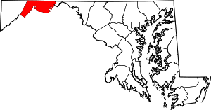
  Location within the state of Maryland | |
| Coordinates: 39°37′23″N 78°57′25″W / 39.62306°N 78.95694°WCoordinates: 39°37′23″N 78°57′25″W / 39.62306°N 78.95694°W | |
| Country | United States |
| State | Maryland |
| County | Allegany |
| Area | |
| • Total | 0.3 sq mi (0.7 km2) |
| • Land | 0.3 sq mi (0.7 km2) |
| • Water | 0 sq mi (0 km2) |
| Elevation | 2,010 ft (610 m) |
| Population (2010) | |
| • Total | 153 |
| • Density | 534/sq mi (206.0/km2) |
| Time zone | Eastern (EST) (UTC-5) |
| • Summer (DST) | EDT (UTC-4) |
| FIPS code | 24-13225 |
| GNIS feature ID | 2583594 |
Carlos is an unincorporated community and census-designated place (CDP) in Allegany County, Maryland, United States.[1] As of the 2010 census it had a population of 153.[2]
Carlos is located 3 miles (5 km) southwest of Frostburg near the western border of Allegany County, at the foot of Big Savage Mountain.
References
- ↑ "Geographic Names Information System". Carlos (Populated Place). U.S. Geological Survey. 2009-01-29.
- ↑ "Geographic Identifiers: 2010 Demographic Profile Data (G001): Carlos CDP, Maryland". U.S. Census Bureau, American Factfinder. Retrieved May 23, 2013.
This article is issued from Wikipedia - version of the 10/29/2016. The text is available under the Creative Commons Attribution/Share Alike but additional terms may apply for the media files.