Gardner Township, Johnson County, Kansas
| Gardner Township | |
|---|---|
| Township | |
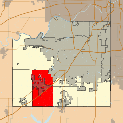 Location in Johnson County | |
| Coordinates: 38°46′02″N 94°54′46″W / 38.76722222°N 94.91277778°WCoordinates: 38°46′02″N 94°54′46″W / 38.76722222°N 94.91277778°W | |
| Country | United States |
| State | Kansas |
| County | Johnson |
| Area | |
| • Total | 39.21 sq mi (101.6 km2) |
| • Land | 39.03 sq mi (101.1 km2) |
| • Water | 0.19 sq mi (0.5 km2) 0% |
| Population (2010) | |
| • Total | 2,143 |
| • Estimate (2011) | 2,143 |
| • Density | 55/sq mi (21/km2) |
| Time zone | Central |
| ZIP codes | 66019, 66030, 66031 |
| Area code(s) | (913) |
| GNIS feature ID | 479557 |
Gardner Township is one of seven townships in Johnson County, Kansas, USA. As of the 2010 census, its population was 2143.
Unincorporated towns
- New Century
Adjacent Townships
- Lexington Township Northwest
- McCamish West
- Olathe Northeast
Cemeteries
The township contains these one cemetery: Gardner Cemetery
Transportation
Major highways
Airports and landing strips
- New Century Aircenter
- Gardner Municipal Airport
Rivers, Lakes (Ponds), Streams
- Kill Creek
- Lake Gardner
Parks
- Westside Ballpark
- Gardner Celebration Park
- Gardner Airport Park
School districts
- Gardner SD 231
- Desoto USD 232
- Olathe USD 233
External links
- "Township of Gardner". Geographic Names Information System. United States Geological Survey. Retrieved 2014-01-04.
Municipalities and communities of Johnson County, Kansas, United States | ||
|---|---|---|
| Cities | 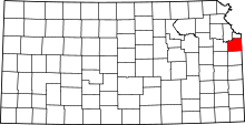 | |
| Unincorporated communities | ||
| Townships | ||
| Footnotes | ‡This populated place also has portions in an adjacent county or counties | |
This article is issued from Wikipedia - version of the 5/17/2016. The text is available under the Creative Commons Attribution/Share Alike but additional terms may apply for the media files.