Clearview City, Kansas
| Clearview City, Kansas | |
|---|---|
| Unincorporated community | |
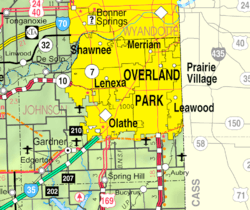 KDOT map of Johnson County (legend) | |
 Clearview City | |
| Coordinates: 38°56′44″N 94°59′55″W / 38.94556°N 94.99861°WCoordinates: 38°56′44″N 94°59′55″W / 38.94556°N 94.99861°W[1] | |
| Country | United States |
| State | Kansas |
| County | Johnson |
| Township | Lexington |
| Housing Complex | 1941 |
| Annexed | 1998 (with De Soto) |
| Area | |
| • Total | 26.56 sq mi (68.8 km2) |
| • Land | 26.45 sq mi (68.5 km2) |
| • Water | 0.11 sq mi (0.3 km2) |
| Elevation[1] | 915 ft (279 m) |
| Time zone | CST (UTC-6) |
| • Summer (DST) | CDT (UTC-5) |
| ZIP codes | 66018, 66019 |
| Area code | 913 |
| FIPS code | 20-13900 [1] |
| GNIS ID | 479182 [1] |
Clearview City was an unincorporated community in Johnson County, Kansas, Kansas, United States,[1] but is now a part of the city of De Soto.
History
Clearview City was the home of the now defunct Sunflower Army Ammunition Plant. The town was initially used a housing complex built for workers at the ammunition plant. Clearview City was annexed by the city of De Soto in 1998.
In 1987, six acres (2.4 ha) of houses in the eastern part of Clearview City were demolished due to damage and age. That area is now home to Countryside Elementary School.
Geography
Clearview City is located approximately 36 miles west of Kansas City, Kansas and is two miles (3 km) south of De Soto. It is located in Lexington Township.
References
External links
- Johnson County Map, KDOT
- Johnson County Map, U.S. Census
Municipalities and communities of Johnson County, Kansas, United States | ||
|---|---|---|
| Cities | 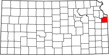 | |
| Unincorporated communities | ||
| Townships | ||
| Footnotes | ‡This populated place also has portions in an adjacent county or counties | |
This article is issued from Wikipedia - version of the 11/4/2016. The text is available under the Creative Commons Attribution/Share Alike but additional terms may apply for the media files.