Emmons County, North Dakota
| Emmons County, North Dakota | |
|---|---|
 Emmons County Courthouse in Linton | |
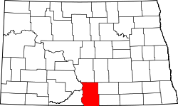 Location in the U.S. state of North Dakota | |
 North Dakota's location in the U.S. | |
| Founded | November 9, 1883 |
| Seat | Linton |
| Largest city | Linton |
| Area | |
| • Total | 1,555 sq mi (4,027 km2) |
| • Land | 1,510 sq mi (3,911 km2) |
| • Water | 45 sq mi (117 km2), 2.9% |
| Population (est.) | |
| • (2015) | 3,402 |
| • Density | 2.4/sq mi (1/km²) |
| Congressional district | At-large |
| Time zone | Central: UTC-6/-5 |
Emmons County is a county located in the U.S. state of North Dakota. As of the 2010 census, the population was 3,550.[1] Its county seat has been Linton since 1899.[2][3] The county was created by the 1879 territorial legislature and named for James A. Emmons (1845–1919), a steamboat operator and early Bismarck merchant and entrepreneur. It was organized on November 9, 1883.[3][4]
History
Emmons County was established before the state of North Dakota. The county was originated by an act of territorial legislation during February 1879. However, it was not officially organized until November 9, 1883. It was named for James A. Emmons,[5] who was a steamboat navigator from Virginia and merchant in Bismarck.
The first settlers of Emmons County came from parts of Europe and the eastern United States. The earliest were mostly soldiers discharged from Fort Yates, but civilians began arriving in the 1880s. Two large ethnic groups soon developed: Germans from both Russia and Germany (the latter called Reich Germans) and Hollanders who had come from the eastern United States. The Hollanders lived only in the southwestern part of the county while the Germans settled throughout the area.
The settlers faced many hardships upon arrival in Emmons County. The worst of which was probably the adverse climate. Extreme seasonal variations in temperature, wind, rain, and snow made life difficult. Severe winter blizzards and summer thunderstorms and tornadoes were a constant threat. To shelter themselves against the sometimes inhospitable climate, early settlers built crude but durable dwellings using whatever materials they could find. The first building in Emmons county was a log cabin built near what was to become the town of Winona in 1852. Some other early dwellings were built of tar paper or local rocks. Rocks were a common sight on the prairie, but stone houses were a rarity because they took great care to build. The most common type of dwelling was the sod house, which later became synonymous with pioneering life on the prairie. Sod is prairie grass and dirt cut into blocks and stacked to form walls. Sod was an effective solution to the problem of limited lumber availability. These crude dwellings were eventually abandoned in favor of more modern homes as soon as the necessary building materials became available.
Another hardship was transportation. There were no roads and the nearest railroad station was in Eureka, South Dakota (40 miles (64 km) away). A horse and wagon were typically used for transportation. Buffalo bones were often piled up and used as landmarks to aid navigating the vast prairie. Since no bridges existed, creeks and streams presented a major difficulty. Settlers usually traveled in pairs and used both of their teams of horses to pull each wagon across a creek or stream. The first bridge in Emmons County was not built until 1889.
The Missouri River is the western boundary of Emmons County. An early industry to develop was one of providing cordwood for the steamboats plying the river. The steamboats could operate only during the summer months due to the river freezing over in the winter. The lack of bridges necessitated the use of ferries to traverse the river (the last of which washed ashore in 1940). Barges were also used to move freight up and down the river.
The history of the towns that presently exist in Emmons County begins with Braddock. It is the oldest existing town in the county (established in 1898). That same year, Braddock had the distinction of becoming the first town in Emmons County to receive train service. In 1899, Linton was plotted for the sole purpose of creating a geographically centralized government. The town was named for George Lynn. By 1901, Linton had reached a population of 118 and within two years the population had jumped to 245 residents. Linton was incorporated as a village in 1906 and incorporated as a town in 1914. Tirsbol was established in 1902 ten miles (16 km) south of Linton. However, it eventually became the center of the German immigrant community and was renamed Strasburg. Also in 1902, the town of Hague was established southeast of Strasburg. The last currently existing town to be incorporated is Hazelton. At the time, the Northern Pacific Railroad was trying to start hundreds of new towns along their tracks to compete with the Burlington Northern Railroad. The railroad decided to plot the town on land near Williamsport owned by a man named John Roop. Hazelton was named after Hazel, John Roop's daughter.
Although no longer in existence, Winona was the oldest town created in Emmons County. Winona was established in 1874 with the name "Devil’s Colony". The town was built to serve the soldiers at Fort Yates as well as the few farmers in the area. During the 1880s it was the largest town between Bismarck, North Dakota and Pierre, South Dakota. The first school in the county was built there in 1884 and the county's first newspaper was published there in 1885. By 1894, the population of the town peaked at over 200. However, the creation of Linton spelled the beginning of the end for Winona and it was gone by the early 1900s. The town of Williamsport was established in 1883 by a group of people from Ashland, Ohio and was the first county seat of government. The creation of Linton and Hazelton drained the population from Williamsport and it was subsequently abandoned in 1903.
Other towns no longer in existence include Emmonsburg which was located west of Linton, in Beaver Bay, on the Missouri River. It was established in 1888 and abandoned in 1912. Glencoe was also established in 1883 in the northwest corner of the county, but it was abandoned in 1930. Winchester was established in 1884 along Beaver Creek (west of Linton), but was completely abandoned by 1909. Westfield was established in 1888 in the center of the Dutch colony. It was named for Westfield, Iowa but was never incorporated. Godkin was established in 1902, six miles (10 km) north of Linton. Its name was later changed to Temvik, combining the last names of early settlers - the Tempel brothers and Ed Larvik. By 1925 its population peaked to over 200, but the effects of the 1930s Great Depression and being bypassed by the construction of U.S. Highway 83 led to its downfall. Its post office was abandoned in 1968. The final town of note is Kintyre. Settled by Swedes and Norwegians in the 1880s; it was established in 1908 and subsequently abandoned.
Geography
According to the U.S. Census Bureau, the county has a total area of 1,555 square miles (4,030 km2), of which 1,510 square miles (3,900 km2) is land and 45 square miles (120 km2) (2.9%) is water.[6]
Adjacent counties
- Burleigh County (north)
- Kidder County (northeast)
- Logan County (east)
- McIntosh County (southeast)
- Campbell County, South Dakota (south)
- Sioux County (west)
- Morton County (northwest)
Major highways
 U.S. Highway 83
 North Dakota Highway 11
 North Dakota Highway 13
 North Dakota Highway 34
 North Dakota Highway 1804
National protected areas
- Appert Lake National Wildlife Refuge
- Springwater National Wildlife Refuge
- Sunburst Lake National Wildlife Refuge
Demographics
| Historical population | |||
|---|---|---|---|
| Census | Pop. | %± | |
| 1880 | 38 | — | |
| 1890 | 1,971 | 5,086.8% | |
| 1900 | 4,349 | 120.6% | |
| 1910 | 9,796 | 125.2% | |
| 1920 | 11,288 | 15.2% | |
| 1930 | 12,467 | 10.4% | |
| 1940 | 11,699 | −6.2% | |
| 1950 | 9,715 | −17.0% | |
| 1960 | 8,462 | −12.9% | |
| 1970 | 7,200 | −14.9% | |
| 1980 | 5,877 | −18.4% | |
| 1990 | 4,830 | −17.8% | |
| 2000 | 4,331 | −10.3% | |
| 2010 | 3,550 | −18.0% | |
| Est. 2015 | 3,402 | [7] | −4.2% |
| U.S. Decennial Census[8] 1790-1960[9] 1900-1990[10] 1990-2000[11] 2010-2015[1] | |||
2000 census
As of the census of 2000, there were 4,331 people, 1,786 households, and 1,241 families residing in the county. The population density was 3 people per square mile (1/km²). There were 2,168 housing units at an average density of 1 per square mile (1/km²). The racial makeup of the county was 99.05% White, 0.05% Black or African American, 0.14% Native American, 0.16% Asian, 0.18% Pacific Islander, 0.30% from other races, and 0.12% from two or more races. 1.15% of the population were Hispanic or Latino of any race. 69.2% were of German, 7.5% Dutch, 6.9% American and 5.1% Norwegian ancestry.
There were 1,786 households out of which 27.20% had children under the age of 18 living with them, 61.00% were married couples living together, 4.40% had a female householder with no husband present, and 30.50% were non-families. 28.40% of all households were made up of individuals and 16.40% had someone living alone who was 65 years of age or older. The average household size was 2.38 and the average family size was 2.92.
In the county the population was spread out with 24.80% under the age of 18, 3.70% from 18 to 24, 22.30% from 25 to 44, 23.60% from 45 to 64, and 25.60% who were 65 years of age or older. The median age was 44 years. For every 100 females there were 101.70 males. For every 100 females age 18 and over, there were 100.90 males.
The median income for a household in the county was $26,119, and the median income for a family was $31,857. Males had a median income of $23,235 versus $15,590 for females. The per capita income for the county was $14,604. About 14.70% of families and 20.10% of the population were below the poverty line, including 23.40% of those under age 18 and 24.60% of those age 65 or over.
2010 census
As of the 2010 United States Census, there were 3,550 people, 1,594 households, and 1,003 families residing in the county.[12] The population density was 2.4 inhabitants per square mile (0.93/km2). There were 2,085 housing units at an average density of 1.4 per square mile (0.54/km2).[13] The racial makeup of the county was 98.5% white, 0.4% American Indian, 0.2% Asian, 0.1% black or African American, 0.2% from other races, and 0.8% from two or more races. Those of Hispanic or Latino origin made up 1.0% of the population.[12] In terms of ancestry, 69.1% were German, 16.8% were Russian, 12.3% were Norwegian, 9.6% were Dutch, 5.9% were English, and 1.4% were American.[14]
Of the 1,594 households, 22.6% had children under the age of 18 living with them, 55.4% were married couples living together, 3.8% had a female householder with no husband present, 37.1% were non-families, and 34.4% of all households were made up of individuals. The average household size was 2.19 and the average family size was 2.81. The median age was 50.5 years.[12]
The median income for a household in the county was $35,615 and the median income for a family was $45,464. Males had a median income of $31,468 versus $26,700 for females. The per capita income for the county was $21,358. About 12.4% of families and 16.1% of the population were below the poverty line, including 22.0% of those under age 18 and 20.4% of those age 65 or over.[15]
Communities
Cities
Township
Defunct townships
Unincorporated communities
See also
References
- 1 2 "State & County QuickFacts". United States Census Bureau. Retrieved October 31, 2013.
- ↑ "Find a County". National Association of Counties. Retrieved 2011-06-07.
- 1 2 "County History". Official Portal for North Dakota State Government. Retrieved 4 May 2011.
- ↑ "Dakota Territory, South Dakota, and North Dakota: Individual County Chronologies". Dakota Territory Atlas of Historical County Boundaries. The Newberry Library. 2006. Retrieved February 3, 2015.
- ↑ Gannett, Henry (1905). The Origin of Certain Place Names in the United States. Govt. Print. Off. p. 119.
- ↑ "2010 Census Gazetteer Files". United States Census Bureau. August 22, 2012. Retrieved January 28, 2015.
- ↑ "County Totals Dataset: Population, Population Change and Estimated Components of Population Change: April 1, 2010 to July 1, 2015". Retrieved July 2, 2016.
- ↑ "U.S. Decennial Census". United States Census Bureau. Retrieved January 28, 2015.
- ↑ "Historical Census Browser". University of Virginia Library. Retrieved January 28, 2015.
- ↑ Forstall, Richard L., ed. (March 27, 1995). "Population of Counties by Decennial Census: 1900 to 1990". United States Census Bureau. Retrieved January 28, 2015.
- ↑ "Census 2000 PHC-T-4. Ranking Tables for Counties: 1990 and 2000" (PDF). United States Census Bureau. April 2, 2001. Retrieved January 28, 2015.
- 1 2 3 "DP-1 Profile of General Population and Housing Characteristics: 2010 Demographic Profile Data". United States Census Bureau. Retrieved 2016-03-14.
- ↑ "Population, Housing Units, Area, and Density: 2010 - County". United States Census Bureau. Retrieved 2016-03-14.
- ↑ "DP02 SELECTED SOCIAL CHARACTERISTICS IN THE UNITED STATES – 2006-2010 American Community Survey 5-Year Estimates". United States Census Bureau. Retrieved 2016-03-14.
- ↑ "DP03 SELECTED ECONOMIC CHARACTERISTICS – 2006-2010 American Community Survey 5-Year Estimates". United States Census Bureau. Retrieved 2016-03-14.
- 1 2 3 4 "Geographic Change Notes for North Dakota". United States Census Bureau. Retrieved 2010-06-17.
- ↑ "1990s boundary changes, Geographic Change Notes: North Dakota". United States Census Bureau. Retrieved 2009-05-28.
 |
Morton County | Burleigh County | Kidder County | |
| Sioux County | |
Logan County | ||
| ||||
| | ||||
| Campbell County, South Dakota | McIntosh County |
Municipalities and communities of Emmons County, North Dakota, United States | ||
|---|---|---|
| Cities | | |
| Township | ||
| Unorganized territories |
| |
| Unincorporated communities | ||
Coordinates: 46°17′N 100°14′W / 46.28°N 100.24°W