Shire of Duaringa
| Shire of Duaringa Queensland | |||||||||||||
|---|---|---|---|---|---|---|---|---|---|---|---|---|---|
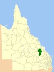 Location within Queensland | |||||||||||||
| Population | 7,757 (2001 census) | ||||||||||||
| • Density | 0.42619/km2 (1.10382/sq mi) | ||||||||||||
| Area | 18,201 km2 (7,027.4 sq mi) | ||||||||||||
| Council seat | Duaringa | ||||||||||||
| Region | Capricornia | ||||||||||||
|
| |||||||||||||
| Website | Shire of Duaringa | ||||||||||||
| |||||||||||||
The Shire of Duaringa was a local government area in the Capricornia region of Queensland, Australia. Duaringa Shire covers an area of 18,201 square kilometres and boasted a population of approximately 11,000. On 15 March 2008 the shires of Duaringa, Emerald, Bauhinia and Peak Downs were amalgamated to form the Central Highlands Region.
History
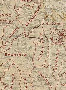
Banana Division was created on 11 November 1879 as one of 74 divisions around Queensland under the Divisional Boards Act 1879.[1] On 20 April 1881 part of Banana Division was separated to create Duaringa Division.[2]
On 4 January 1884, there was an adjustment of boundaries between Bauhinia Division's subdivisions Nos. 2 and 3 and the Duaringa Division.[3][4] Soon after, on 20 March 1884, there was a further adjustment of boundaries between Bauhinia Division's subdivisions Nos. 1 and 3 and Duaringa Division.[5][6]
On 3 March 1892, part of subdivision 2 of the Broadsound Division was transferred to subdivision 3 of the Gogango Division, while another part of subdivision 2 of the Broadsound Division was transferred to the Duaringa Division.[7]
With the passage of the Local Authorities Act 1902, Banana Division became Shire on Banana on 31 March 1903.
On 15 March 2008 the Shires of Duaringa, Emerald, Bauhinia and Peak Downs were amalgamated to form the Central Highlands Region.[8]
Towns and localities
The Shire of Duaringa included the following settlements:
Towns:
Township:
Others
The Aboriginal Shire of Woorabinda is located in five separate locations inside the former Shire of Duaringa - three of them wholly surrounded by Duaringa, and two on the border with Fitzroy Shire.
Economy
Duaringa is a local centre for the region's farmers, who cultivate sorghum and wheat, and graze beef cattle. Mining is another major industry within the Shire, due to the vast coal deposits around Blackwater.
Chairmen
- 1892, 1895, 1898: William Irving Bell (after whom Bell Park at Emu Park is named)[9][10][11]
- 1927: C. A. Barnard [12]
- 1934: E. Adams[13]
References
- ↑ "Proclamation [Nogoa Division]". Queensland Government Gazette. 11 November 1879. p. 25:1004.
- ↑ "Proclamation [Banana & Duaringa Divisions]". Queensland Government Gazette. 23 April 1881. p. 28:1068-1069.
- ↑ "Proclamation [Bauhinia Division amended]". Queensland Government Gazette. 5 January 1884. p. 34:19.
- ↑ "Proclamation [Duaringa Division amended]". Queensland Government Gazette. 5 January 1884. p. 34:20-21.
- ↑ "Proclamation [Bauhinia Division amended]". Queensland Government Gazette. 22 March 1884. p. 34:893.
- ↑ "Proclamation [Duaringa Division amended]". Queensland Government Gazette. 22 March 1884. p. 34:894.
- ↑ "Order in Council [Broadsound, Gogango and Duaringa Divisions]". Queensland Government Gazette. 5 March 1892. p. 55:920.
- ↑ "Agency ID11030, Central Highlands Regional Council". Queensland State Archives. Retrieved 8 September 2013.
- ↑ "Duaringa Divisional Board.". The Daily Northern Argus. 1, (2319). Queensland, Australia. 26 September 1892. p. 5. Retrieved 2 November 2016 – via National Library of Australia.
- ↑ "DUARINGA DIVISIONAL BOARD.". Morning Bulletin. XLVIII, (9689). Queensland, Australia. 13 May 1895. p. 6. Retrieved 2 November 2016 – via National Library of Australia.
- ↑ "QUEENSLAND NEWS.". Morning Bulletin. LXI, (10,520). Queensland, Australia. 4 April 1898. p. 5. Retrieved 2 November 2016 – via National Library of Australia.
- ↑ Pugh, Theophilus Parsons (1927). Pugh's Almanac for 1927. Retrieved 13 June 2014.
- ↑ "COUNTRY WOMEN". Morning Bulletin (21,141). Queensland, Australia. 27 April 1934. p. 14. Retrieved 2 November 2016 – via National Library of Australia.
External links
- University of Queensland: Queensland Places: Duaringa and Duaringa Shire
- Official website at the Wayback Machine (archived March 5, 2010)
Coordinates: 23°43′03.64″S 149°40′11″E / 23.7176778°S 149.66972°E