Big Spring State Forest Picnic Area
| Big Spring State Forest Picnic Area | |
|---|---|
| Pennsylvania State Park | |
| Natural Monument (IUCN III) | |
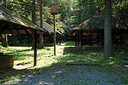 Pavilions in a wooded area at Big Spring State Forest Picnic Area | |
| Named for: Big Spring Run | |
| Country | United States |
| State | Pennsylvania |
| County | Perry |
| Township | Toboyne |
| Location | [1] |
| - coordinates | 40°15′52″N 77°39′03″W / 40.26444°N 77.65083°WCoordinates: 40°15′52″N 77°39′03″W / 40.26444°N 77.65083°W |
| - elevation | 1,375 ft (419.1 m) [1] |
| Area | 45 acres (18 ha) |
| Founded | 1936 |
| Managed by | Pennsylvania Department of Conservation and Natural Resources |
 Location of Big Spring State Park in Pennsylvania | |
| Website : Big Spring State Forest Picnic Area | |
Big Spring State Forest Picnic Area is a 45-acre (18 ha) Pennsylvania state park in Toboyne Township, Perry County, Pennsylvania in the United States. The park is on Pennsylvania Route 274, 5.5 miles (8.9 km) southwest of New Germantown. Big Spring State Forest Picnic Area is a hiking and picnic area. A partially completed railroad tunnel in Conococheague Mountain is a feature of the park.
History
The area surrounding Big Spring State Forest Picnic Area is now largely a wild area. This was not the case in the 19th century. One of the first businesses at the foot of Conococheague Mountain was a tannery. This tannery was in operation from the early 19th century until 1860. The tannery was converted into an axe handle factory in 1871. The Perry Lumber Railroad, a narrow gauge railway also operated in the area. It hauled lumber to tanneries, barrel manufacturers and charcoal furnaces.[2]
The abandoned railroad tunnel is a remnant of the lumber era that dominated the economy of much of Pennsylvania in the 19th century. The Newport and Shermans Valley Railroad extended its line into the Big Spring area in an attempt to connect with the Path Valley Railroad on the other side of Conococheague Mountain in Franklin County. This tunnel was left incomplete and stands as a reminder of the lumber/railroad era.[2]
Although the railroad may have failed in its effort to tunnel through the mountain, the tracks remained. These rails were used to transport picnickers into the area during the early 20th century. The current facilities at Big Spring State Forest Picnic Area were built during the Great Depression in the 1930s by the Civilian Conservation Corps. It was formally opened in 1936.[2]
Recreation
Big Spring State Forest Picnic Area offers recreational opportunities to those interested in picnicking and hiking. The pavilions built by the CCC and picnic tables are available in many areas of the park. A one mile trail leads to the abandoned railroad tunnel in Conococheague Mountain. The park also serves as a trailhead for the Iron Horse Trail in Tuscarora State Forest.[2]
Nearby state parks
The following state parks are within 30 miles (48 km) of Big Spring State Forest Picnic Area:[3][4][5]
- Caledonia State Park (Adams and Franklin Counties)
- Colonel Denning State Park (Cumberland County)
- Cowans Gap State Park (Fulton County)
- Fowlers Hollow State Park (Perry County)
- Greenwood Furnace State Park (Huntingdon County)
- Kings Gap Environmental Education and Training Center (Cumberland County)
- Little Buffalo State Park (Perry County)
- Mont Alto State Park (Franklin County)
- Pine Grove Furnace State Park (Cumberland County)
- Trough Creek State Park (Huntingdon County)
References
- 1 2 "Big Spring State Park". Geographic Names Information System. United States Geological Survey. August 30, 1990. Retrieved 2008-04-03.
- 1 2 3 4 "Big Spring State Forest Picnic Area". Pennsylvania Department of Conservation and Natural Resources. Retrieved 2006-11-08.
- ↑ "Find a Park by Region (interactive map)". Pennsylvania Department of Conservation and Natural Resources. Retrieved November 18, 2011.
- ↑ 2007 General Highway Map Perry County Pennsylvania (PDF) (Map). 1:65,000. Pennsylvania Department of Transportation, Bureau of Planning and Research, Geographic Information Division. Retrieved 2007-07-28. Note: shows Big Spring State Park
- ↑ Michels, Chris (1997). "Latitude/Longitude Distance Calculation". Northern Arizona University. Archived from the original on 11 April 2008. Retrieved 2008-04-20.
External links
- "Big Spring State Forest Picnic Area official map" (PDF). (45 KB)