Tyler State Park (Pennsylvania)
| Tyler State Park | |
|---|---|
| Pennsylvania State Park | |
| Natural Monument (IUCN III) | |
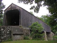 Schofield Ford Covered Bridge | |
| Named for: Mr. and Mrs. George F. Tyler | |
| Country | United States |
| State | Pennsylvania |
| County | Bucks |
| Townships | Newtown, Northampton |
| Location | [1] |
| - coordinates | 40°13′30″N 74°59′00″W / 40.22500°N 74.98333°WCoordinates: 40°13′30″N 74°59′00″W / 40.22500°N 74.98333°W |
| - elevation | 236 ft (72 m) [1] |
| Area | 1,711 acres (692 ha) |
| Founded | 1974 |
| Managed by | Pennsylvania Department of Conservation and Natural Resources |
 Location of Tyler State Park in Pennsylvania | |
| Website : Tyler State Park | |
Tyler State Park is a Pennsylvania state park on 1,711 acres (692 ha) in Newtown and Northampton Townships, Bucks County, Pennsylvania in the United States.[2]
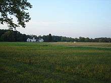
Park roads, trails, and facilities are carefully nestled within the original farm and woodland setting. Neshaminy Creek meanders through the park, dividing the land into several sections. Before becoming a state park, the land was owned by Mr. and Mrs. George F. Tyler who purchased the land between 1919 and 1928. Their first purchase was the Solly Farm, currently leased to Hostelling International at the north end of the park. The Solly House served as the Tyler’s country home until the George F. Tyler Mansion was constructed. The mansion is now the administration building of the Bucks County Community College.
The Tylers developed an Ayrshire dairy herd. In addition, they raised poultry, sheep and pigs, and had a stable of about 25 fine riding horses. The croplands were mainly used to supply feed for the livestock.
Old original stone dwellings in the park stand as fine examples of early farm dwellings of rural Pennsylvania. Some structures date back to the early 18th century. A date stone (1775) can be found on a house located by the bicycle trail north of the pedestrian causeway in the center of the park. Ten original farm dwellings are currently being leased as private residences.
The land for the park was acquired as part of the Project 70 Land Acquisition and Borrowing Act, with the governor approving the acquisition on November 17, 1964.[3] The park was formally dedicated on May 25, 1974.[2]
Tyler State Park contains a 36-hole disc golf course and a former landfill, which is now mainly used for archaeological digs by students from Council Rock school district elementary schools.
Tyler State Park is home to many different species of birds. The creek is home to water snakes, turtles, and eels. The secluded sections of the park are home to foxes, deer, beavers, wild turkey, rabbits, and black bears.
One of the main attractions in the park is the Schofield Ford Covered Bridge, originally built in 1874. The bridge burned down due to arson on October 7, 1991, but was rebuilt with raised funds and reopened on September 7, 1997.[4]
Nearby state parks

The following state parks are within 30 miles (48 km) of Tyler State Park:[5][6][7]
- Benjamin Rush State Park (Philadelphia County)
- Bull's Island Recreation Area (Hunterdon County, New Jersey)
- Delaware and Raritan Canal State Park (New Jersey)
- Delaware Canal State Park (Bucks and Northampton Counties)
- Evansburg State Park (Montgomery County)
- Fort Washington State Park (Montgomery County)
- Neshaminy State Park (Bucks County)
- Nockamixon State Park (Bucks County)
- Norristown Farm Park (Montgomery County)
- Ralph Stover State Park (Bucks County)
- Rancocas State Park (Burlington County, New Jersey)
- Round Valley State Park (Hunterdon County, New Jersey)
- Spruce Run State Park (Hunterdon County, New Jersey)
- Washington Crossing State Park (Mercer County, New Jersey)
References
- 1 2 "Tyler State Park". Geographic Names Information System. United States Geological Survey. August 30, 1990. Retrieved 2007-12-13.
- 1 2 "Tyler State Park". Pennsylvania Department of Conservation and Natural Resources. Retrieved 2007-12-13.
- ↑ Forrey, William C. (1984). History of Pennsylvania's State Parks. Harrisburg, Pennsylvania: Bureau of State Parks, Office of Resources Management, Department of Environmental Resources, Commonwealth of Pennsylvania. pp. 43–44. OCLC 17824084.
- ↑ Madsen, Kelly. "Burned bridges meet different fates". The Intelligencer.
- ↑ 2007 General Highway Map Bucks County Pennsylvania (PDF) (Map). 1:65,000. Pennsylvania Department of Transportation, Bureau of Planning and Research, Geographic Information Division. Note: shows Tyler State Park
- ↑ Michels, Chris (1997). "Latitude/Longitude Distance Calculation". Northern Arizona University. Retrieved 2008-04-23.
- ↑ "Find a Park by Region (interactive map)". Pennsylvania Department of Conservation and Natural Resources. Retrieved November 18, 2011.
External links
| Wikimedia Commons has media related to Tyler State Park (Pennsylvania). |
- "Tyler State Park official map" (PDF). (166.2 KB)