Baffin Island
| Native name: <span class="nickname" ">ᕿᑭᖅᑖᓗᒃ (Qikiqtaaluk) | |
|---|---|
 | |
 | |
| Geography | |
| Location | Northern Canada |
| Coordinates | 69°N 72°W / 69°N 72°WCoordinates: 69°N 72°W / 69°N 72°W |
| Archipelago | Canadian Arctic Archipelago |
| Area | 507,451 km2 (195,928 sq mi) |
| Area rank | 5th |
| Highest elevation | 2,147 m (7,044 ft) |
| Highest point | Mount Odin |
| Administration | |
| Territory | Nunavut |
| Largest settlement | Iqaluit (pop. 6,699) |
| Demographics | |
| Population | 10,745 (2006) |
| Pop. density | 0.02 /km2 (0.05 /sq mi) |
| Ethnic groups | Inuit (72.7%), non-Aboriginal (25.3%), Indian (0.7%), Métis (0.5%)[1] |
Baffin Island (Inuktitut: ᕿᑭᖅᑖᓗᒃ, Qikiqtaaluk IPA: [qikiqtaːluk], French: Île de Baffin or Terre de Baffin), in the Canadian territory of Nunavut, is the largest island in Canada and the fifth largest island in the world. Its area is 507,451 km2 (195,928 sq mi) and its population is about 11,000 (2007 estimate). It is located 65.4215 N and 70.9654 W. Named after English explorer William Baffin,[2] it is likely that the island was known to Pre-Columbian Norse explorers from Greenland and Iceland and that it was the location of Helluland, spoken of in the Icelandic sagas (the Grœnlendinga saga and the Saga of Erik the Red, Eiríks saga rauða).
Geography


Iqaluit, the capital of Nunavut, is located on the southeastern coast. Until 1987, the town shared the name Frobisher Bay with the bay on which it is located.[3]
To the south lies Hudson Strait, separating Baffin Island from mainland Quebec.[4] South of the western end of the island is the Fury and Hecla Strait[5] which separates the island from the Melville Peninsula[6] on the mainland. To the east are Davis Strait[7] and Baffin Bay,[8] with Greenland beyond.[4] The Foxe Basin,[9] the Gulf of Boothia[10] and Lancaster Sound[11] separate Baffin Island from the rest of the archipelago to the west and north.
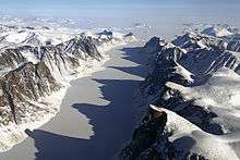
The Baffin Mountains run along the northeastern shore of the island and are a part of the Arctic Cordillera. Mount Odin is the highest peak, with an elevation of at least 2,143 m (7,031 ft), although some sources say 2,147 m (7,044 ft).[12][13] Another peak of note is Mount Asgard, located in Auyuittuq National Park, with an elevation of 2,011 m (6,598 ft). Mount Thor, with an elevation of 1,675 m (5,495 ft), is said to have the greatest purely vertical drop of any mountain on Earth, at 1,250 m (4,100 ft).[14]
The two largest lakes on the island lie in the south-central part of the island: Nettilling Lake (5,542 km2 (2,140 sq mi)) and Amadjuak Lake (3,115 km2 (1,203 sq mi)) further south.[15][16][17]
The Barnes Ice Cap, in the middle of the island, has been retreating since at least the early 1960s, when the Geographical Branch of the then-Department of Mines and Technical Surveys sent a three-man survey team to the area to measure isostatic rebound and cross-valley features of the Isortoq River. Conversely, in the 1970s parts of Baffin Island failed to have the usual ice-free period in the summer.[18]
History
The island has been continuously inhabited by Inuit peoples for thousands of years. In September 2008, Nunatsiaq News reported that a team led by Dr. Patricia Sutherland of the Canadian Museum of Civilization had found archaeological remains of yarn, Eurasian rats, tally sticks, a carved wooden Dorset culture face mask depicting Caucasian features, and possible architectural remains, which indicated that European traders and possibly settlers had been on Baffin Island not later than AD 1000.[19] What the source of this Old World contact may have been is unclear; the report states: "Dating of some yarn and other artifacts, presumed to be left by Vikings on Baffin Island, have produced an age that predates the Vikings by several hundred years. So [...] you have to consider the possibility that as remote as it may seem, these finds may represent evidence of contact with Europeans prior to the Vikings' arrival in Greenland".[19] Dr Sutherland's research eventually led to a 2012 announcement that whetstones had been found with remnants of alloys indicative of Viking presence.[20] The archaeological site at Tanfield Valley is thought to have been a trading post, and thus Baffin Island would be Helluland.[21]
Politics
Baffin Island is part of the Qikiqtaaluk Region.
Communities by population

| Iqaluit[maps 1] | 6,669[22] |
| Pangnirtung[maps 2] | 1,325[22] |
| Pond Inlet[maps 3] | 1,315[22] |
| Clyde River[maps 4] | 820[22] |
| Arctic Bay[maps 5] | 690[22] |
| Kimmirut[maps 6] | 411[22] |
| Nanisivik[maps 7] | 0 (From 77 in 2001 - mine closure)[22] |
Additionally, the communities of Qikiqtarjuaq (pop. 473) [maps 8] and Cape Dorset (pop. 1236) [maps 9] are located on offshore islands.
There are discussions to start the Baffinland Iron Mine, an iron ore mine with a 21-year life, at Mary River, and to build a railway and a port to transport the ore.[23] This may create a temporary mining community there.
Wildlife

Baffin Island has both year-round and summer visitor wildlife. On land, examples of year-round wildlife are barren-ground caribou, polar bear, Arctic fox, Arctic hare, lemming and Arctic wolf.
Barren-ground caribou herds that migrate in a limited range from northern Baffin island down to the southern part in winter, even to the Frobisher Bay peninsula, next to Resolution Island and migrate back north in the summer. In 2012, a survey of caribou herds found that the local population was only about 5000, a decrease of as much as 95% from the 1990s.[24]
Polar bears can be found all along the coast of Baffin Island, but are most prevalent where the sea ice takes the form of pack ice, where their major food sources — ringed seals (jar seal) and bearded seals — live. Polar bears mate approximately every year with from one to three cubs being born around March. Female polar bears may travel 10–20 km (6–12 mi) inland to find a large snow bank where they dig a den in which to spend the winter and later for giving birth. The polar bear population here is one of 19 genetically distinct demes of the circumpolar region.[25]
Arctic fox can usually be found where polar bears venture on the fast ice close to land in their search for seals. Arctic foxes are scavengers, and often follow polar bears to get their leavings. On Baffin Island, Arctic foxes are sometimes trapped by Inuit, but there is not a robust fur industry.
Arctic hare are found throughout Baffin island. Their fur is pure white in winter and molts to a scruffy dark grey in summer. Arctic hares and lemmings are a primary food source for Arctic foxes and Arctic wolves.
Lemmings are also found throughout the island, and are a major food source for Arctic foxes, Arctic wolves and the snowy owl. In the winter, lemmings dig complicated tunnel systems through the snow drifts in order to get to their food supply of dry grasses and lichens.[26]
The Arctic wolf, and the Baffin Island wolf, a gray wolf subspecies, is also a year-round resident of Baffin Island. Unlike the gray wolf in southern climes, Arctic wolves often do not hunt in packs, although a male-female pair may hunt together.
In the water (or under the ice) the year-round visitors are mainly the ringed seal.
The ringed seal lives off-shore within 8 km (5 mi) of land. During the winter, it makes a number of breathing holes through ice up to 8 ft (2.4 m) thick by visiting each one often, and keeping the hole open and free from ice. In March, when a female is ready to whelp, she will enlarge one of the breathing holes that has snow over it, and create a small "igloo" where they whelp one or two pups. Within three weeks the pups are in the water and swimming. During the summer, ringed seals keep to a narrow territory approximately 3 km (2 mi) along the shoreline. If pack ice moves in, they may venture out 4–10 km (2–6 mi) and follow the pack ice, dragging themselves up on an ice floe to take advantage of the sun.

Nesting birds are summer land visitors to Baffin Island. Baffin Island is one of the major nesting destinations from the Eastern and Mid-West flyways for many species of migrating birds. Waterfowl include Canada goose, snow goose and brant goose (brent goose). Shore birds include the phalarope, various waders (commonly called sandpipers), murres including Brünnich's guillemot, and plovers. Three gull species also nest on Baffin Island: glaucous gull, herring gull and ivory gull.
Long-range travellers include the Arctic tern, which migrates from Antarctica every spring. The variety of water birds that nest here include coots, loons, mallards, and many other duck species.
Water species that visit Baffin Island in the summer are:
Harp seals (or saddle-backed seals), which migrate from major breeding grounds off the coast of Labrador and the southeast coast of Greenland to Baffin Island for the summer.[27] Migrating at speeds of 15–20 kilometres per hour (9–12 mph), they all come up to breathe at the same time, then dive and swim up to 1–2 km (0.62–1.24 mi) before surfacing again. They migrate in large pods consisting of a hundred or more seals, to within 1–8 km (0.62–4.97 mi) of the shoreline, which they then follow, feeding on crustaceans and fish.
Walrus, which actually do not migrate far off land in the winter. They merely follow the "fast ice", or ice that is solidly attached to land, and stay ahead of it as the ice hardens further and further out to sea. As winter progresses, they will always remain where there is open water free of ice. When the ice melts, they move in to land and can be found basking on rocks close to shore. One of the largest walrus herds can be found in the Foxe Basin on the western side of Baffin Island.
Beluga or white whales migrate along the coast of Baffin Island as some head north to the feeding grounds in the Davis Strait between Greenland and Baffin Island, or into the Hudson Strait or any of the bays and estuaries in between. Usually travelling in pods of two or more, they can often be found very close to shore (100 m (330 ft), or less), where they come up to breathe every 30 seconds or so as they make their way along the coastline eating crustaceans.
Narwhals, which are known for their long, spiralling single tusk (males only), can also be found along the coast of Baffin Island in the summer. Much like their beluga cousins they may be found in pairs or even in a large pod of ten or more males, females and newborns. They also can be often found close to the shoreline, gracefully pointing their tusks skyward as they come up for air. When they first arrive, the males arrive a few weeks ahead of the females and young.
The largest summer visitor to Baffin Island is the bowhead whale. Found throughout the Arctic range, one group of bowhead whales are known to migrate to the Foxe Basin, a bay on the western side of Baffin Island. It is still not known whether they visit for the lush sea bounty or to calve in the Foxe Basin.
Climate

Baffin Island lies in the path of a generally northerly airflow all year round, so, like much of northeastern Canada, it has an extremely cold climate. This brings very long, cold winters and foggy, cloudy summers, which have helped to add to the remoteness of the island. Spring thaw arrives much later than normal for a position straddling the Arctic Circle; around early June at Iqaluit in the south-east to early/mid-July on the north coast where glaciers run right down to sea level. Snow, even heavy snow, can occur at any time of the year, although it is least likely in July and early August. Average annual temperatures at Iqaluit are around −9.5 °C (14.9 °F), compared with Reykjavík,[maps 10] around 5 °C (41 °F), which is at a similar latitude.[28]
Sea ice surrounds the island for most of the year, and only disappears completely from the north coast for short unpredictable periods from mid- to late June until the end of September.
Most of Baffin Island lies above the Arctic Circle and all the communities from Pangnirtung northwards have polar night in winter and the midnight sun in summer. The eastern community of Clyde River has twilight instead of night from April 26 until May 13, continuous sunlight for 2½ months from May 14 to July 28, then twilight instead of night from July 29 until August 16. This gives the community just over 3½ months without true night. In the winter the sun sets on November 22 and does not rise again until January 19 of the next year. However, there is twilight for at least 4 hours a day, unlike places such as Eureka.
See also
References
- ↑ 2006 Aboriginal Population Profile for Nunavut communities.
- ↑ Quinn, Joyce A.; Woodward, Susan L. (31 January 2015). Earth's Landscape: An Encyclopedia of the World's Geographic Features. ABC-CLIO. p. 82. ISBN 978-1-61069-446-9.
- ↑ About Iqaluit: History
- 1 2 Hudson Strait
- ↑ Fury and Hecla Strait
- ↑ Melville Peninsula
- ↑ Davis Strait
- ↑ Baffin Bay with Greenland to the east
- ↑ Foxe Basin
- ↑ Gulf of Boothia
- ↑ Lancaster Sound
- ↑ "Mount Odin, Nunavut". Peakbagger.com.
- ↑ Mount Odin at the Atlas of Canada
- ↑ Mount Thor -The Greatest Vertical Drop on Earth!
- ↑ Nunavut - Lake Areas and Elevation (lakes larger than 400 square kilometres)
- ↑ Nettilling Lake location
- ↑ Amadjuak Lake location
- ↑ Cora Cheney, Crown of The World, Dodd, Merad, and Company, New York, 1979.
- 1 2 Jane George, "Kimmirut site suggests early European contact", Nunatsiaq News, September 12, 2008.
- ↑ Second Proven Viking Outpost in North America
- ↑ CBC, The Nature of Things episode "The Norse: An Arctic Mystery", season 2012-2013 episode 5 airdate 22 November 2012; archived at the Wayback Machine, November 27, 2012.
- 1 2 3 4 5 6 7 Statistics Canada (2006). "Statistics Canada - Community Profile". Retrieved 2009-02-03.
- ↑ The Mary River Project
- ↑ Icebergs, feasts and culture in Pond Inlet, Nunavut, CBC News
- ↑ C. Michael Hogan (2008) Polar Bear: Ursus maritimus, globalTwitcher.com, ed. Nicklas Stromberg
- ↑ "Facts About Baffin Island". Retrieved 2016-10-03.
- ↑ Fisheries and Oceans Canada
- ↑ GHCN average monthly temperatures, GISS data for 1971-2000, Goddard Institute for Space Studies
Maps
- ↑ Iqaluit, 63°44′55″N 068°31′11″W / 63.74861°N 68.51972°W
- ↑ Pangnirtung, 66°08′52″N 065°41′58″W / 66.14778°N 65.69944°W
- ↑ Pond Inlet, 72°41′57″N 077°57′33″W / 72.69917°N 77.95917°W
- ↑ Clyde River, 70°28′26″N 068°35′10″W / 70.47389°N 68.58611°W
- ↑ Arctic Bay, 73°02′11″N 085°09′09″W / 73.03639°N 85.15250°W
- ↑ Kimmirut, 62°50′48″N 069°52′07″W / 62.84667°N 69.86861°W
- ↑ Nanisivik, 73°02′05″N 084°32′13″W / 73.03472°N 84.53694°W
- ↑ Qikiqtarjuaq, 67°33′29″N 064°01′29″W / 67.55806°N 64.02472°W
- ↑ Cape Dorset, 64°13′54″N 076°32′25″W / 64.23167°N 76.54028°W
- ↑ Reykjavík, 64°08′N 21°56′W / 64.133°N 21.933°W
Further reading
- Boas, Franz, and Ludger Müller-Wille. Franz Boas Among the Inuit of Baffin Island, 1883-1884 Journals and Letters. Toronto: University of Toronto Press, 1998. ISBN 0-8020-4150-7
- Lee, Alastair. Baffin Island: the Ascent of Mount Asgard. London: Frances Lincoln, 2011. ISBN 9780711232211
- Kuhnlein HV, R Soueida, and O Receveur. 1996. "Dietary Nutrient Profiles of Canadian Baffin Island Inuit Differ by Food Source, Season, and Age". Journal of the American Dietetic Association. 96, no. 2: 155-62.
- Matthiasson, John S. Living on the Land Change Among the Inuit of Baffin Island. Peterborough, Canada: Broadview Press, 1992. ISBN 0-585-30561-7
- Maxwell, Moreau S. Archaeology of the Lake Harbour District, Baffin Island. Mercury series. Ottawa: Archaeological Survey of Canada, National Museum of Man, National Museums of Canada, 1973.
- Sabo, George. Long Term Adaptations Among Arctic Hunter-Gatherers A Case Study from Southern Baffin Island. The Evolution of North American Indians. New York: Garland Pub, 1991. ISBN 0-8240-6111-X
- Sergy, Gary A. The Baffin Island Oil Spill Project. Edmonton, Alta: Environment Canada, 1986.
- Stirling, Ian, Wendy Calvert, and Dennis Andriashek. Population Ecology Studies of the Polar Bear in the Area of Southeastern Baffin Island. [Ottawa]: Canadian Wildlife Service, 1980. ISBN 0-662-11097-8
- Utting, D. J. Report on ice-flow history, deglacial chronology, and surficial geology, Foxe Peninsula, southwest Baffin Island, Nunavut. [Ottawa]: Geological Survey of Canada, 2007. http://dsp-psd.pwgsc.gc.ca/collection%5F2007/nrcan-rncan/M44-2007-C2E.pdf. ISBN 978-0-662-46367-2
External links
| Wikivoyage has a travel guide for Baffin Island. |
| Wikimedia Commons has media related to Baffin Island. |
- Baffin Island in the Atlas of Canada - Toporama; Natural Resources Canada
- Nunavut Tourism