Whitcomb, Washington
| Whitcomb, Washington | |
|---|---|
| Unincorporated community | |
 Whitcomb, Washington Location of Whitcomb, Washington | |
| Coordinates: 45°51′55″N 119°47′05″W / 45.8654104°N 119.7847528°WCoordinates: 45°51′55″N 119°47′05″W / 45.8654104°N 119.7847528°W[1] | |
| Country | United States |
| State | Washington |
| County | Benton |
| Elevation[2] | 299 ft (91 m) |
| Time zone | Pacific (PST) (UTC-8) |
| • Summer (DST) | PDT (UTC-7) |
| ZIP code | 99345 |
| Area code(s) | 509 |
| GNIS feature ID | 1511426[2] |
Whitcomb is an unincorporated community in Benton County, Washington, United States, located approximately 22 miles south of Prosser on the north bank of the Columbia River on the south side of Canoe Canyon.[3]
The community was originally called Luzon before being renamed to Whitcomb on January 31, 1910 in honor of G. Henry Whitcomb. A post office operated in the community from April 10, 1909 until October 31, 1934.[3][4]
References
- ↑ "Whitcomb". Geographic Names Information System. United States Geological Survey. Retrieved 2012-10-28.
- 1 2 "US Board on Geographic Names". United States Geological Survey. 2007-10-25. Retrieved 2008-01-31.
- 1 2 "Station Roster Master List: Whitcomb". Northern Pacific Railway Historical Association. Retrieved October 30, 2012.
- ↑ "Washington Place Names database". Tacoma Public Library. Retrieved October 30, 2012.
Municipalities and communities of Benton County, Washington, United States | ||
|---|---|---|
| Cities | 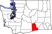 | |
| CDPs | ||
| Unincorporated communities | ||
| Unincorporated communities | ||
This article is issued from Wikipedia - version of the 9/3/2016. The text is available under the Creative Commons Attribution/Share Alike but additional terms may apply for the media files.