Walpack Township, New Jersey
| Walpack Township, New Jersey | |
|---|---|
| Township | |
| Township of Walpack | |
|
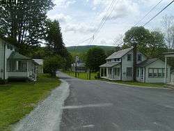
The downtown of Wallpack Center, New Jersey facing towards the east, away from National Park Service Route 615. | |
| Motto: Oldest Municipality in Sussex County | |
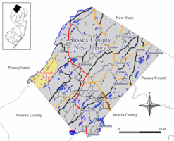 Map of Walpack Township in Sussex County. Inset: Location of Sussex County highlighted in the State of New Jersey. | |
 Census Bureau map of Walpack Township, New Jersey | |
| Coordinates: 41°07′07″N 74°53′39″W / 41.118632°N 74.89404°WCoordinates: 41°07′07″N 74°53′39″W / 41.118632°N 74.89404°W[1][2] | |
| Country |
|
| state |
|
| County | Sussex |
| Earliest mention | October 26, 1731 |
| Incorporated | February 21, 1798 |
| Government[3] | |
| • Type | Township |
| • Body | Township Committee |
| • Mayor | Victor J. Maglio (term ends December 31, 2016)[4][5] |
| • Clerk | Kelly Maglio[4] |
| Area[1] | |
| • Total | 24.702 sq mi (63.979 km2) |
| • Land | 24.050 sq mi (62.289 km2) |
| • Water | 0.652 sq mi (1.689 km2) 2.64% |
| Area rank |
109th of 566 in state 10th of 24 in county[1] |
| Elevation[6] | 436 ft (133 m) |
| Population (2010 Census)[7][8][9] | |
| • Total | 16 |
| • Estimate (2015)[10] | 15 |
| • Rank |
564th of 566 in state 24th of 24 in county[11] |
| • Density | 0.7/sq mi (0.3/km2) |
| • Density rank |
566th of 566 in state 24th of 24 in county[11] |
| Time zone | Eastern (EST) (UTC-5) |
| • Summer (DST) | Eastern (EDT) (UTC-4) |
| ZIP code | 07881 - Walpack Center[12] |
| Area code(s) | 908[13] |
| FIPS code | 3403776640[1][14][15] |
| GNIS feature ID | 0882259[1][16] |
| Website |
www |
Walpack Township is a township in Sussex County, New Jersey, United States. As of the 2010 United States Census, the township had a population of 16,[7][8][9] reflecting a decline of 25 (-61.0%) from the 41 counted in the 2000 Census, which had in turn declined by 26 (-38.8%) from the 67 counted in the 1990 Census.[17] Walpack Township was one of only four municipalities in New Jersey with a double-digit population as of the 2010 Census, and it placed third behind Tavistock (population 5) and Pine Valley (population 12), both in Camden County.[18]
Walpack Township dates back to October 26, 1731, when it was first mentioned as Walpake in Hunterdon County. The area covered by the present-day township was set off to Morris County upon that county's creation in 1739, and became part of the newly formed Sussex County in 1753. As of April 15, 1754, Walpack's boundaries were defined as a "precinct". Walpack was formally incorporated as a township by an act of the New Jersey Legislature on February 21, 1798. Portions of the township were taken to form Montague Township (March 26, 1759), Sandyston Township (February 26, 1762) and the now-defunct Pahaquarry Township in Warren County (December 27, 1824). Territory was gained from Stillwater Township in 1935.[19]
The current Walpack Township is named from a corruption of the Lenape Native American word "wahlpeck," which means "turn-hole," or an eddy or whirlpool, a compound of two Native American words, "woa-lac" (a hole), and "tuppeck" (a pool),[20] though other sources attribute the name to mean "very deep water"[21] or "sudden bend of a stream around the base of a rock".[22]
New Jersey Monthly magazine ranked Walpack Township as its 18th best place to live in its 2008 rankings of the "Best Places To Live" in New Jersey.[23]
History
The Andrew Snable House was built in 1801 and was added to the National Register of Historic Places on July 23, 1979.[24]
Geography
According to the United States Census Bureau, the township had a total area of 24.702 square miles (63.979 km2), including 24.050 square miles (62.289 km2) of land and 0.652 square miles (1.689 km2) of water (2.64%).[1][2] The township is located in the Minisink Valley that extends from the Delaware Water Gap north to Port Jervis, New York.
Unincorporated communities, localities and place names located partially or completely within the township include Dry Pond, Flat Brook, Flatbrookville, Haneys Mill, Harding Lake, Long Pond and Walpack Center.[25]
Demographics
| Historical population | |||
|---|---|---|---|
| Census | Pop. | %± | |
| 1810 | 591 | — | |
| 1820 | 822 | 39.1% | |
| 1830 | 660 | * | −19.7% |
| 1840 | 728 | 10.3% | |
| 1850 | 783 | 7.6% | |
| 1860 | 851 | 8.7% | |
| 1870 | 647 | −24.0% | |
| 1880 | 575 | −11.1% | |
| 1890 | 436 | −24.2% | |
| 1900 | 371 | −14.9% | |
| 1910 | 286 | −22.9% | |
| 1920 | 258 | −9.8% | |
| 1930 | 178 | −31.0% | |
| 1940 | 207 | * | 16.3% |
| 1950 | 204 | −1.4% | |
| 1960 | 248 | 21.6% | |
| 1970 | 384 | 54.8% | |
| 1980 | 150 | −60.9% | |
| 1990 | 67 | −55.3% | |
| 2000 | 41 | −38.8% | |
| 2010 | 16 | −61.0% | |
| Est. 2015 | 15 | [10][26] | −6.2% |
| Population sources: 1810-1920[27] 1840[28] 1850-1870[29] 1850[30] 1870[31] 1880-1890[32] 1890-1910[33] 1910-1930[34] 1930-1990[35] 2000[36][37] 2010[7][8][9] * = Territorial change in previous decade.[19] | |||
Census 2010
The 2010 United States Census counted 16 people, 8 households, and 4 families residing in the township. The population density was 0.7 per square mile (0.27/km2). The township contained 15 housing units at an average density of 0.6 per square mile (0.23/km2). The racial makeup of the township was 93.75% (15) White, 0.00% (0) Black or African American, 0.00% (0) Native American, 0.00% (0) Asian, 0.00% (0) Pacific Islander, 0.00% (0) from other races, and 6.25% (1) from two or more races. Hispanics or Latinos of any race were 0.00% (0) of the population.[7]
Out of a total of 8 households, 12.5% had children under the age of 18 living with them, 37.5% were married couples living together, 0.0% had a female householder with no husband present, and 50.0% were non-families. 50.0% of all households were made up of individuals, and 25.0% had someone living alone who was 65 years of age or older. The average household size was 2.00 and the average family size was 3.00.[7]
In the township, 12.5% of the population were under the age of 18, 12.5% from 18 to 24, 18.8% from 25 to 44, 31.3% from 45 to 64, and 25.0% who were 65 years of age or older. The median age was 56.5 years. For every 100 females the census counted 100.0 males, but for 100 females at least 18 years old, it was 100.0 males.[7]
The Census Bureau's 2006-2010 American Community Survey showed that (in 2010 inflation-adjusted dollars) median household income was $108,333 (with a margin of error of +/- $155,555) and the median family income was $127,500 (+/- $88,897). Males had a median income of $ (+/- $) versus $57,813 (+/- $26,023) for females. The per capita income for the borough was $36,663 (+/- $14,435). About 0.0% of families and 0.0% of the population were below the poverty line, including 0.0% of those under age 18 and 0.0% of those age 65 or over.[38]
Census 2000
As of the 2000 United States Census[14] there were 41 people, 20 households, and 12 families residing in the township. The population density was 1.7 people per square mile (0.7/km²). There were 34 housing units at an average density of 1.4 per square mile (0.5/km²). The racial makeup of the township was 100.00% White.[36][37]
There were 20 households out of which 20.0% had children under the age of 18 living with them, 50.0% were married couples living together, 10.0% had a female householder with no husband present, and 40.0% were non-families. 40.0% of all households were made up of individuals and 10.0% had someone living alone who was 65 years of age or older. The average household size was 2.05 and the average family size was 2.75.[36][37]
In the township the population was spread out with 19.5% under the age of 18, 2.4% from 18 to 24, 19.5% from 25 to 44, 31.7% from 45 to 64, and 26.8% who were 65 years of age or older. The median age was 49 years. For every 100 females there were 95.2 males. For every 100 females age 18 and over, there were 106.3 males.[36][37]
The median income for a household in the township was $22,250, and the median income for a family was $22,250. Males had a median income of $46,250 versus $0 for females. The per capita income for the township was $17,624. None of the population and none of the families were below the poverty line.[36][37]
Government
Local government
Walpack Township is governed under the Township form of government. The governing body is a three-member Township Committee, whose members are elected directly by the voters at-large in partisan elections to serve three-year terms of office on a staggered basis, with one seat coming up for election each year as part of the November general election in a three-year cycle.[3][39] At an annual reorganization meeting, the Township Committee selects one of its members to serve as Mayor and another as Deputy Mayor.
As of 2016, members of the Walpack Township Committee are Mayor Victor J. Maglio (R, term on committee ends December 31, 2017; term as mayor ends 2016), Deputy Mayor James Heigis (R, term on committee ends 2018; term as deputy mayor ends 2016) and Janina Wycalek (D, 2016).[4][40][41][42][43]
Federal, state and county representation
Walpack Township is located in the 5th Congressional District[44] and is part of New Jersey's 24th state legislative district.[8][45][46]
New Jersey's Fifth Congressional District is represented by Scott Garrett (R, Wantage Township).[47] New Jersey is represented in the United States Senate by Cory Booker (D, Newark, term ends 2021)[48] and Bob Menendez (D, Paramus, 2019).[49][50]
For the 2016–2017 session (Senate, General Assembly), the 24th Legislative District of the New Jersey Legislature is represented in the State Senate by Steve Oroho (R, Franklin) and in the General Assembly by Parker Space (R, Wantage Township) and Gail Phoebus (R, Andover Township).[51] The Governor of New Jersey is Chris Christie (R, Mendham Township).[52] The Lieutenant Governor of New Jersey is Kim Guadagno (R, Monmouth Beach).[53]
Sussex County is governed by a Board of Chosen Freeholders whose five members are elected at-large in partisan elections on a staggered basis, with either one or two seats coming up for election each year. At an annual reorganization meeting held in the beginning of January, the board selects a Freeholder Director and Deputy Director from among its members, with day-to-day supervision of the operation of the county delegated to a County Administrator.[54] As of 2014, Sussex County's Freeholders are Freeholder Director Richard Vohden (R, Green Township, 2016),[55] Deputy Director Dennis J. Mudrick (R, Sparta Township, 2015),[56] Phillip R. Crabb (R, Franklin, 2014),[57] George Graham (R, Stanhope, 2016)[58] and Gail Phoebus (R, Andover Township, 2015).[59][54] Graham was chosen in April 2013 to fill the seat vacated by Parker Space, who had been chosen to fill a vacancy in the New Jersey General Assembly.[60] Constitutional officers elected on a countywide basis are County Clerk Jeff Parrott (R, 2016),[61] Sheriff Michael F. Strada (R, 2016)[62] and Surrogate Gary R. Chiusano (R, filling the vacancy after the resignation of Nancy Fitzgibbons).[63][60] The County Administrator is John Eskilson.[64][65]
Politics
As of March 23, 2011, there were a total of 22 registered voters in Walpack Township, of which 1 (4.5% vs. 16.5% countywide) were registered as Democrats, 17 (77.3% vs. 39.3%) were registered as Republicans and 2 (9.1% vs. 44.1%) were registered as Unaffiliated. There were 2 voters registered to other parties.[66] Among the township's 2010 Census population, 137.5% (vs. 65.8% in Sussex County) were registered to vote, including 157.1% of those ages 18 and over (vs. 86.5% countywide).[66][67]
In the 2012 presidential election, Republican Mitt Romney received 10 votes (83.3% vs. 59.4% countywide), ahead of Democrat Barack Obama with 2 votes (16.7% vs. 38.2%) and other candidates with no votes (0.0% vs. 2.1%), among the 12 ballots cast by the township's 18 registered voters, for a turnout of 66.7% (vs. 68.3% in Sussex County).[68] In the 2008 presidential election, Republican John McCain received 14 votes (70.0% vs. 59.2% countywide), ahead of Democrat Barack Obama with 3 votes (15.0% vs. 38.7%) and other candidates with 2 votes (10.0% vs. 1.5%), among the 20 ballots cast by the township's 28 registered voters, for a turnout of 71.4% (vs. 76.9% in Sussex County).[69] In the 2004 presidential election, Republican George W. Bush received 22 votes (78.6% vs. 63.9% countywide), ahead of Democrat John Kerry with 6 votes (21.4% vs. 34.4%) and other candidates with no votes (0.0% vs. 1.3%), among the 28 ballots cast by the township's 35 registered voters, for a turnout of 80.0% (vs. 77.7% in the whole county).[70]
In the 2013 gubernatorial election, Republican Chris Christie received 77.8% of the vote (7 cast), ahead of Democrat Barbara Buono with 22.2% (2 votes), and other candidates receiving no votes, among the 9 ballots cast by the township's 19 registered voters, for a turnout of 47.4%.[71][72] In the 2009 gubernatorial election, Republican Chris Christie received 11 votes (91.7% vs. 63.3% countywide), ahead of Democrat Jon Corzine with one vote (8.3% vs. 25.7%), Independent Chris Daggett with no votes (0.0% vs. 9.1%) and other candidates with no votes (0.0% vs. 1.3%), among the 12 ballots cast by the township's 23 registered voters, yielding a 52.2% turnout (vs. 52.3% in the county).[73]
Education
Students in Kindergarten through sixth grade attend the schools of the Sandyston-Walpack Consolidated School District, together with students from Sandyston Township.[74] The school is located in Layton. As of the 2013-14 school year, the district's one school had an enrollment of 148 students and 17.3 classroom teachers (on an FTE basis), for a student–teacher ratio of 8.5:1.[75]
Students in seventh through twelfth grade for public school attend Kittatinny Regional High School located in Hampton Township, which also serves students who reside in Fredon Township, Hampton Township, Stillwater Township and Sandyston Township.[76] The high school is located on a 96-acre (39 ha) campus in Hampton Township, about seven minutes outside of the county seat of Newton. As of the 2013-14 school year, the school had an enrollment of 1,123 students and 96.0 classroom teachers (on an FTE basis), for a student–teacher ratio of 11.7:1.[77] Kittatinny Regional High School was recognized as a National Blue Ribbon School of Excellence in 1997-98.[78]
Transportation
As of May 2010, the township had a total of 20.01 miles (32.20 km) of roadways, all of which were maintained by the municipality.[79]
Notable people
People who were born in, residents of, or otherwise closely associated with Walpack Township include:
- Frank Chapot (1932–2016), Olympic silver medalist equestrian.[80]
References
- 1 2 3 4 5 6 2010 Census Gazetteer Files: New Jersey County Subdivisions, United States Census Bureau. Accessed May 21, 2015.
- 1 2 US Gazetteer files: 2010, 2000, and 1990, United States Census Bureau. Accessed September 4, 2014.
- 1 2 2012 New Jersey Legislative District Data Book, Rutgers University Edward J. Bloustein School of Planning and Public Policy, March 2013, p. 110.
- 1 2 3 Directory, Walpack Township. Accessed August 2, 2016.
- ↑ 2016 New Jersey Mayors Directory, New Jersey Department of Community Affairs. Accessed June 14, 2016.
- ↑ U.S. Geological Survey Geographic Names Information System: Township of Walpack, Geographic Names Information System. Accessed March 14, 2013.
- 1 2 3 4 5 6 DP-1 - Profile of General Population and Housing Characteristics: 2010 for Walpack township, Sussex County, New Jersey, United States Census Bureau. Accessed February 26, 2013.
- 1 2 3 4 Municipalities Grouped by 2011-2020 Legislative Districts, New Jersey Department of State, p. 11. Accessed January 6, 2013.
- 1 2 3 Profile of General Demographic Characteristics: 2010 for Walpack township, New Jersey Department of Labor and Workforce Development. Accessed February 26, 2013.
- 1 2 PEPANNRES - Annual Estimates of the Resident Population: April 1, 2010 to July 1, 2015 - 2015 Population Estimates for New Jersey municipalities, United States Census Bureau. Accessed May 22, 2016.
- 1 2 GCT-PH1 Population, Housing Units, Area, and Density: 2010 - State -- County Subdivision from the 2010 Census Summary File 1 for New Jersey, United States Census Bureau. Accessed February 26, 2013.
- ↑ Look Up a ZIP Code for Walpack Center, NJ, United States Postal Service. Accessed February 26, 2013.
- ↑ Area Code Lookup - NPA NXX for Walpack, NJ, Area-Codes.com. Accessed October 29, 2014.
- 1 2 American FactFinder, United States Census Bureau. Accessed September 4, 2014.
- ↑ A Cure for the Common Codes: New Jersey, Missouri Census Data Center. Accessed October 31, 2012.
- ↑ US Board on Geographic Names, United States Geological Survey. Accessed September 4, 2014.
- ↑ Table 7. Population for the Counties and Municipalities in New Jersey: 1990, 2000 and 2010, New Jersey Department of Labor and Workforce Development, February 2011. Accessed February 26, 2013.
- ↑ New Jersey: 2010 - Population and Housing Unit Counts - 2010 Census of Population and Housing (CPH-2-32), United States Census Bureau, August 2012. Accessed February 26, 2013.
- 1 2 Snyder, John P. The Story of New Jersey's Civil Boundaries: 1606-1968, Bureau of Geology and Topography; Trenton, New Jersey; 1969. p. 232. Accessed October 25, 2012.
- ↑ Snell, James P. (1881) History of Sussex and Warren Counties, New Jersey, With Illustrations and Biographical Sketches of its Prominent Men and Pioneers. (Centennial ed., Harmony, NJ: Harmony Press, 1981), pgs. 314, 326.
- ↑ Hutchinson, Viola L. The Origin of New Jersey Place Names, New Jersey Public Library Commission, May 1945. Accessed October 20, 2015.
- ↑ Gannett, Henry. The Origin of Certain Place Names in the United States, p. 31. United States Government Printing Office, 1905. Accessed October 20, 2015.
- ↑ "Best Places To Live - The Complete Top Towns List 1-100", New Jersey Monthly, February 21, 2008. Accessed February 24, 2008.
- ↑ National Register of Historic Places Inventory Nomination Form for Andrew Snable House, National Park Service. Accessed October 20, 2015.
- ↑ Locality Search, State of New Jersey. Accessed April 16, 2015.
- ↑ Census Estimates for New Jersey April 1, 2010 to July 1, 2015, United States Census Bureau. Accessed May 22, 2016.
- ↑ Compendium of censuses 1726-1905: together with the tabulated returns of 1905, New Jersey Department of State, 1906. Accessed July 21, 2013.
- ↑ Bowen, Francis. American Almanac and Repository of Useful Knowledge for the Year 1843, p. 231, David H. Williams, 1842. Accessed February 26, 2013.
- ↑ Raum, John O. The History of New Jersey: From Its Earliest Settlement to the Present Time, Volume 1, p. 271, J. E. Potter and company, 1877. Accessed February 26, 2013. "Wallpack is on the western part of the county and forms the boundary between New Jersey and Pennsylvania. Population in 1850, 783; in 1860, 851; and in 1870, 647. This is the smallest township in the county."
- ↑ Debow, James Dunwoody Brownson. The Seventh Census of the United States: 1850, p. 141. R. Armstrong, 1853. Accessed February 26, 2013.
- ↑ Staff. A compendium of the ninth census, 1870, p. 260. United States Census Bureau, 1872. Accessed February 26, 2013.
- ↑ Porter, Robert Percival. Preliminary Results as Contained in the Eleventh Census Bulletins: Volume III - 51 to 75, p. 99. United States Census Bureau, 1890. Accessed February 26, 2013.
- ↑ Thirteenth Census of the United States, 1910: Population by Counties and Minor Civil Divisions, 1910, 1900, 1890, United States Census Bureau, p. 339. Accessed February 26, 2013.
- ↑ Fifteenth Census of the United States : 1930 - Population Volume I, United States Census Bureau, p. 719. Accessed February 26, 2013.
- ↑ Table 6. New Jersey Resident Population by Municipality: 1930 - 1990, New Jersey Department of Labor and Workforce Development. Accessed June 28, 2015.
- 1 2 3 4 5 Census 2000 Profiles of Demographic / Social / Economic / Housing Characteristics for Walpack township, Sussex County, New Jersey, United States Census Bureau. Accessed February 26, 2013.
- 1 2 3 4 5 DP-1: Profile of General Demographic Characteristics: 2000 - Census 2000 Summary File 1 (SF 1) 100-Percent Data for Walpack township, Sussex County, New Jersey, United States Census Bureau. Accessed February 26, 2013.
- ↑ DP03: Selected Economic Characteristics from the 2006-2010 American Community Survey 5-Year Estimates for Walpack township, Sussex County, New Jersey, United States Census Bureau. Accessed February 26, 2013.
- ↑ "Forms of Municipal Government in New Jersey", p. 7. Rutgers University Center for Government Studies. Accessed June 3, 2015.
- ↑ 2016 Municipal Data Sheet, Walpack Township. Accessed August 2, 2016. As of date accessed, Maglio is listed with an incorrect term-end year of 2015.
- ↑ Sussex County General Election November 3, 2015 Summary Report Official Results, Sussex County, New Jersey Clerk, updated November 6, 2015. Accessed August 1, 2016.
- ↑ Sussex County General Election November 4, 2014 Summary Report Official Results, Sussex County, New Jersey Clerk, updated November 10, 2014. Accessed August 1, 2016.
- ↑ Sussex County General and School Election November 5, 2013 Summary Report Official Results, Sussex County, New Jersey Clerk, updated November 7, 2013. Accessed August 1, 2016.
- ↑ Plan Components Report, New Jersey Redistricting Commission, December 23, 2011. Accessed January 6, 2013.
- ↑ 2016 New Jersey Citizen's Guide to Government, p. 65, New Jersey League of Women Voters. Accessed July 20, 2016.
- ↑ Districts by Number for 2011-2020, New Jersey Legislature. Accessed January 6, 2013.
- ↑ Directory of Representatives: New Jersey, United States House of Representatives. Accessed January 5, 2012.
- ↑ About Cory Booker, United States Senate. Accessed January 26, 2015. "He now owns a home and lives in Newark's Central Ward community."
- ↑ Biography of Bob Menendez, United States Senate, January 26, 2015. "He currently lives in Paramus and has two children, Alicia and Robert."
- ↑ Senators of the 114th Congress from New Jersey. United States Senate. Accessed January 26, 2015. "Booker, Cory A. - (D - NJ) Class II; Menendez, Robert - (D - NJ) Class I"
- ↑ Legislative Roster 2016-2017 Session, New Jersey Legislature. Accessed January 17, 2016.
- ↑ "About the Governor". State of New Jersey. Retrieved 2010-01-21.
- ↑ "About the Lieutenant Governor". State of New Jersey. Retrieved 2010-01-21.
- 1 2 Sussex County Board of Chosen Freeholders, Sussex County, New Jersey. Accessed July 28, 2014.
- ↑ Richard A. Vohden, Sussex County, New Jersey. Accessed July 28, 2014.
- ↑ Dennis J. Mudrick, Sussex County, New Jersey. Accessed July 28, 2014.
- ↑ Phillip R. Crabb, Sussex County, New Jersey. Accessed July 28, 2014.
- ↑ George Graham, Sussex County, New Jersey. Accessed July 28, 2014.
- ↑ Gail Phoebus, Sussex County, New Jersey. Accessed July 28, 2014.
- 1 2 Miller, Jennifer Jean. "George Graham Chosen as Freeholder at Sussex County Republican Convention", TheAlternativePress.com, April 13, 2013. Accessed April 25, 2013. "Graham will fill the freeholder seat that New Jersey Assemblyman Parker Space left to take his new position. Space recently took the seat, which formerly belonged to Gary Chiusano, who in turn, was appointed to the spot of Sussex County Surrogate, following the retirement of Surrogate Nancy Fitzgibbons."
- ↑ Home Page, Sussex County Clerk's Office. Accessed July 28, 2014.
- ↑ Sheriff's Office, Sussex County, New Jersey. Accessed July 28, 2014.
- ↑ Home Page, Sussex County Surrogate. Accessed July 28, 2014.
- ↑ County Administrator, Sussex County, New Jersey. Accessed July 28, 2014.
- ↑ Sussex County Official Directory 2014, Sussex County, New Jersey. Accessed July 28, 2014.
- 1 2 Voter Registration Summary - Sussex, New Jersey Department of State Division of Elections, March 23, 2011. Accessed February 26, 2013.
- ↑ GCT-P7: Selected Age Groups: 2010 - State -- County Subdivision; 2010 Census Summary File 1 for New Jersey, United States Census Bureau. Accessed February 26, 2013.
- ↑ General Election November 6, 2012: District Report - Group Detail, Sussex County, New Jersey Clerk, run date November 30, 2012. Accessed February 26, 2013.
- ↑ 2008 Presidential General Election Results: Sussex County, New Jersey Department of State Division of Elections, December 23, 2008. Accessed February 26, 2013.
- ↑ 2004 Presidential Election: Sussex County, New Jersey Department of State Division of Elections, December 13, 2004. Accessed February 26, 2013.
- ↑ "Governor - Sussex County" (PDF). New Jersey Department of Elections. January 29, 2014. Retrieved December 24, 2014.
- ↑ "Number of Registered Voters and Ballots Cast - November 5, 2013 - General Election Results - Sussex County" (PDF). New Jersey Department of Elections. January 29, 2014. Retrieved December 24, 2014.
- ↑ 2009 Governor: Sussex County, New Jersey Department of State Division of Elections, December 31, 2009. Accessed February 26, 2013.
- ↑ About Us, Sandyston-Walpack Consolidated School District. Accessed February 25, 2013. "The elementary students who live in the townships of Sandyston and Walpack attend here. The students of middle and high school age attend Kittatinny Regional High School located in Hampton Township."
- ↑ District information for Sandyston-Walpack Township School District, National Center for Education Statistics. Accessed May 27, 2016.
- ↑ Kittatiny Regional School District 2015 Report Card Narrative, New Jersey Department of Education. Accessed May 28, 2016. "Located in beautiful, rural Sussex County in northwest New Jersey, Kittatinny Regional School District serves the five municipalities of Fredon Township, Hampton Township, Sandyston Township, Stillwater Township and the Township of Walpack. The District is comprised of 125 square miles and has a school population of approximately 1100 students."
- ↑ School Data for Kittatinny High School District, National Center for Education Statistics. Accessed May 28, 2016.
- ↑ Blue Ribbon Schools Program: Schools Recognized 1982-1983 through 1999-2002 (PDF), United States Department of Education. Accessed February 20, 2013.
- ↑ Sussex County Mileage by Municipality and Jurisdiction, New Jersey Department of Transportation, May 2010. Accessed July 18, 2014.
- ↑ Fox, Margalit. "Frank Chapot, Olympic Show Jumper and Mainstay of the Sport, Dies at 84", The New York Times, June 25, 2016. Accessed June 26, 2016. "The son of Frank Joseph Chapot and the former Dorothy Davis, Frank Davis Chapot was born on Feb. 24, 1932, in Camden, N.J. He was reared on his parents' horse farm in Walpack, N.J."
External links
- Township website
- Web page for Walpack Township, Sussex County, New Jersey
- Sandyston-Walpack Consolidated School
- Sandyston-Walpack Consolidated School's 2014–15 School Report Card from the New Jersey Department of Education
- Data for Sandyston-Walpack Consolidated School, National Center for Education Statistics
- Kittatinny Regional High School
Municipalities and communities of Sussex County, New Jersey, United States | ||
|---|---|---|
| Boroughs |  | |
| Town | ||
| Townships | ||
| CDPs | ||
| Other unincorporated communities | ||
 |
Lehman Township, PA | Delaware Township, PA | Sandyston Township | |
| |
Hampton Township | |||
| ||||
| | ||||
| Hardwick Township and Middle Smithfield Township, PA |
Stillwater Township |