Transportation in Greater St. Louis
Transportation in Greater St. Louis includes road, rail, and air transportation modes connecting the communities in the area with domestic and international transportation networks. Parts of Greater St. Louis also support a public transportation network that includes bus and light rail service.
Roads and highways
Greater St. Louis contains seven Interstates, including four primary routes (I-44, I-55, I-64, and I-70), and three auxiliary routes (I-270, I-170, and I-255). Greater St. Louis also is linked by four U.S. Highways: US 40, US 50, US 61, and US 67.
Interstates
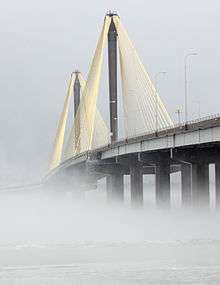
Among the primary Interstates, I-70 runs west to east through Warren, St. Charles, and St. Louis counties and the city of St. Louis, leaving Missouri over the newly completed Stan Musial Veterans Memorial Bridge into St. Clair and Madison counties in Illinois. I-55 runs south to north through Jefferson and St. Louis counties and the city of St. Louis, there briefly merging with I-44, then crossing the Poplar Street Bridge with I-64. In East St. Louis, Illinois, I-64 branches off and I-70 joins I-55. The 55/70 duplex continues into Troy, Illinois in Madison County, with I-55 continuing north toward Chicago. I-44 enters Greater St. Louis at Sullivan in Crawford County, eastward through Franklin and St. Louis counties, merging briefly with I-55 in St. Louis, and terminating at I-70. I-64's western terminus is in Wentzville, Missouri at I-70 in St. Charles County, crossing the Daniel Boone Bridge into St. Louis County, entering St. Louis city, and overlapping with I-55 across the Poplar Street Bridge. I-64 then crosses through St. Clair and Clinton counties before exiting the region.
The "beltway" serving Greater St. Louis is the combination of I-270 and I-255, the former a mostly western bypass of St. Louis City. I-270 crosses into Illinois on the northern edge of St. Louis County on the Chain of Rocks Bridge, and continues through Madison County until ending at the I-70/I-55 interchange near Troy, Illinois. In southern St. Louis County, I-270 ends at the I-55 interchange near Mehlville, where it becomes I-255, which continues east across the Mississippi River on the Jefferson Barracks Bridge into Monroe County, where it turns north, crossing through St. Clair County until ending at I-270 in Madison County. Another secondary route is I-170, which is entirely within St. Louis County, running southerly from Hazelwood to Richmond Heights.
U.S. Highways
Among the U.S. Highways in the region, US 40 parallels or shares an alignment with I-70 in the west, then later with I-64 in St. Charles County; the duplex continues until merging with I-70 at the Poplar Street Bridge. US 40 continues with I-70 through Madison County. US 50 enters Greater St. Louis near Gerald, eastward through Franklin County; at Union, it meets I-44, both continuing to Sunset Hills in St. Louis County. US 50, eastward, merges with US 61 and US 67 (Lindbergh Boulevard.) The US 50/US 61/US 67 triplex continues to the I-255/I-270/I-55 interchange, where they follow I-255 across the Mississippi River. US 50 continues east through Monroe County into St. Clair County, running concurrently with I-64 into O'Fallon, where US 50 splits, continuing through Clinton County. (US 50 ends in Ocean City, Maryland.)
US 61 enters the region from the south, parallelling I-55 in Jefferson County, continuing to Festus where it duplexes with US 67. US 61/US 67 continues into St. Louis County until reaching the I-255/I-270/I-55 interchange, where 61/67 follow Lindbergh Boulevard. US 61 continues north into Frontenac, where it joins westbound I-64. US 61 continues west through St. Louis County and into St. Charles County, then leaves I-64 in Wentzville and continues north into Lincoln County and beyond. (I-64's western terminus is at this junction with I-70 and US 40/61.) US 67 enters the region northbound in Farmington, where it continues into Festus, duplexing with US 61 and parallelling I-55. US 67 splits from US 61 in Frontenac (where 61 turns west), with 67 continuing north on Lindbergh Boulevard, tunneling under Lambert-St. Louis International Airport. At Missouri Route 367, US 67 turns north, crosses the Missouri River on the Clark Bridge into Illinois, through Madison and Jersey counties, then leaving the region.
Bridges
- Bellefontaine Bridge
- Blanchette Memorial Bridge
- Chain of Rocks Bridge (old US 66)
- Clark Bridge
- Daniel Boone Bridge
- Discovery Bridge
- Eads Bridge
- Jefferson Barracks Bridge
- Lewis Bridge
- MacArthur Bridge
- Martin Luther King Bridge
- Merchants Bridge
- McKinley Bridge
- New Chain of Rocks Bridge
- Old St. Charles Bridge (demolished)
- Poplar Street Bridge
- Stan Musial Veterans Memorial Bridge
- Veterans Memorial Bridge
- Wabash Bridge
- Washington Bridge
Airports
Greater St. Louis is served by more than a dozen airports, although the majority of its enplanements are at Lambert-St. Louis International Airport, in northwest St. Louis County. In 2010, Lambert-St. Louis had more than 6 million enplanements, making it the 31st-busiest airport in the US.[1] The region's other major airport is MidAmerica St. Louis Airport, a cargo airport in Belleville, Illinois that is part of Scott Air Force Base. Reliever airports in Greater St. Louis include: St. Charles Airport and St. Charles County Smartt Airport; Spirit of St. Louis Airport in Chesterfield, Missouri; St. Louis Regional Airport in Alton, Illinois; and St. Louis Downtown Airport in Cahokia, Illinois. Other general airports in the region are Creve Coeur Airport, Farmington Regional Airport, Festus Memorial Airport, Greensfield Airport, St. Clair Regional Airport, St. Louis Metro-East Airport, Sullivan Regional Airport, and Washington Regional Airport.
Rail Service
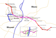
Light rail service in Greater St. Louis serves St. Louis County and the city of St. Louis through MetroLink, a light rail system with two lines (the Red Line and the Blue Line) operated by the Bi-State Development Agency. The Red Line originates at Lambert-St. Louis International Airport in northwest St. Louis County, continues southeast with seven stations before entering St. Louis city, where it joins the Blue Line. The Blue Line begins in Shrewsbury, continues north to Clayton, where it turns east and eventually joins the Red Line. Eastbound from here, there are eight stations before the combined service crossed the Mississippi River on the Eads Bridge into Illinois. The combined light rail continue to Fairview Heights, where the Blue Line ends. The Red Line continues east, ending in Shiloh.
Planned for St. Louis County is the Delmar Loop Trolley, a 2.2-mile planned heritage trolley line that would connect the Delmar Loop district in University City to the Missouri History Museum in St. Louis city.
Bus service
Public transport bus service in Greater St. Louis is offered by several local agencies, including Madison County Transit, MetroBus (operated by the Bi-State Development Agency), and St. Charles Area Transit. Greyhound Lines, Megabus, and Amtrak Thruway Motorcoach operate national bus service in the region.
References
| Topics |  | |
|---|---|---|
| Central city | ||
| Largest cities (over 50,000 in 2010) | ||
| Medium-sized cities (over 20,000 in 2010) | ||
| Largest towns and villages (over 10,000 in 2010) |
| |
| Missouri Counties | ||
| Illinois Counties | ||
| Subregions | ||
