Tarpey, California
Coordinates: 36°47′16″N 119°42′03″W / 36.78778°N 119.70083°W
| Tarpey | |
|---|---|
| Unincorporated community | |
 Tarpey  Tarpey Location in California | |
| Coordinates: 36°47′16″N 119°42′03″W / 36.78778°N 119.70083°W | |
| Country | United States |
| State | California |
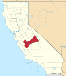
| County | Fresno County |
| Elevation[1] | 344 ft (105 m) |
Tarpey is an unincorporated community in Fresno County, California.[1] It is located on the Southern Pacific Railroad 2.25 miles (3.6 km) south of Clovis,[2] at an elevation of 344 feet (105 m).[1]
A post office operated at Tarpey from 1892 to 1914 and from 1958 to 1961.[2] The name honors Arthur B. Tarpey.[2]
References
This article is issued from Wikipedia - version of the 7/5/2016. The text is available under the Creative Commons Attribution/Share Alike but additional terms may apply for the media files.