Fair Head
| Fair Head (Benmore) | |
|---|---|
| an Bhinn Mhór | |
 Fair Head seen from Ballycastle | |
| Highest point | |
| Elevation | 196 m (643 ft) |
| Coordinates | 55°13′16″N 6°09′14″W / 55.221°N 6.154°WCoordinates: 55°13′16″N 6°09′14″W / 55.221°N 6.154°W |
| Geography | |
 Location in Northern Ireland | |
| Location | County Antrim, Northern Ireland |
| OSI/OSNI grid | D180438 |
| Topo map | OSNI Discoverer 5 |
| Geology | |
| Mountain type | Dolerite sill |
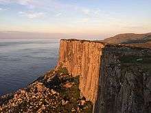
Fair Head or Benmore (from Irish: an Bhinn Mhór)[1] is a rocky headland at the north-eastern corner of County Antrim, Northern Ireland. It lies 3 miles (5 km) east of Ballycastle town, and is the closest part of the mainland to Rathlin Island. Geography books have long measured the length of Ireland "from Fair Head to Mizen Head".[2] It is a very highly regarded rock-climbing location, and is believed to be the biggest expanse of climbable rock in the British Isles.[3]
Setting
The headland of Fair Head rises 196m above the sea. Wild goats can be seen roaming among the rocks beneath the clifftops, where a walkway called The Grey Man's Path winds around the rugged coastline. From the road, a manmade Iron Age island or crannóg can be seen in the middle of a lake, Lough na Cranagh. The lakes are stocked with trout and can be fished during the summer months. All of the land at Fair Head is private farm land, and not owned by National Trust. Access is by the good will of local farm owners.
Many famous Irish artists have painted Fair Head including Maurice Canning Wilks who painted a watercolour from a nearby beach.
Climbing
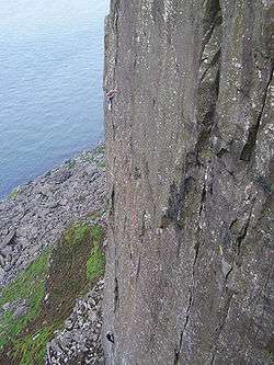

Fair Head is widely regarded as Ireland's finest climbing crag, but for a variety of reasons including its relatively remote location and the physical strength and unfamiliar climbing techniques often required there, does not attract the volume of climbers that one might expect at a crag of such quality. Its cliffs stretch for a distance of over 5 km around the headland, rising to a maximum height of over 100m. They are not sea-cliffs, but have been described as a mountain crag by the sea, since they tower above an extensive boulder field and their isolation and size gives climbing there a big-wall mountaineering feel.
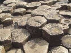
The cliffs are composed of dolerite, giving a mixture of steep cracked walls, corners, and, in many places, sets of columns reminiscent of organ-pipes. The dolerite sits on top of a bed of chalk which is visible in places.
The cliffs abound in well-protected steep crack climbing, between one and four pitches long. Many of the cracks involve hand-jamming, so some climbers tape their hands to protect the skin from what they term "Fair Head rash". Other climbs involve off-width or full-width chimneying, which is not often encountered in other Irish crags. As with nearly all Irish crags, only traditional protection ("clean climbing") is used.
The current guidebook, published in 2002, lists about 400 routes from under grade VS 4c up to E6 6b, but more recent climbing includes routes up to E8 6c.
History
The first climbs at Fair Head were done in the mid-1960s by some Belfast-based climbers and members of the Dublin-based Spillikin Club. Most of these climbs followed loose and dirty chimneys and are rarely repeated nowadays, but the seed had been planted, and before the end of the sixties development of the crag had started in earnest. However, it was not long before the increasing political violence in the North started making its presence felt; the Fair Head area was generally unaffected, but development of the crag slowed to a trickle during the early 1970s. However the attractions of Fair Head eventually proved irresistible and development picked up again in the late seventies, led by the husband-and-wife team of Calvin Torrans and Clare Sheridan and a number of other Dublin climbers. This small band devoted themselves to developing Fair Head, founded the Dal Riada Climbing Club (named after the ancient kingdom which included this area), and acquired a climbing hut nearby to accommodate themselves and other visiting climbers. There is still unclimbed rock at Fair Head; opportunities, mainly in the higher grades, are waiting for those who have the talent and dedication.
Layout
The cliffs are divided into several main sectors. From east to west, these are:
- The Small Crag. This 20m-high sector containing about seventy climbs stretches for 1 km above a heavily forested hillside; the difficulty of access means that abseiling in is usually necessary. Together with the problems often caused by midges, this make the sector unpopular, in spite of the quality of climbing to be had there.
- The Main Crag (including The Prow at its western end) is by far the most important sector. It curves around the headland for 3 km, and contains the longest and best-quality climbs, up to 100m in height. Access is gained mainly by two easy descent gullies near either end of the sector, the Grey Man's Path at the east, and the Ballycastle Gully at the west. The Ballycastle Gully tends to be the more popular descent route for casual visitors, as there is a concentration of easier climbs in the vicinity. Between the two gullies, the starts of climbs can be reached by picking one's way through the boulder-field or by doing a usually-vertical abseil of up to 100m.
- Farrangandoo. This popular small sector consists of columns with intervening cracks every 2m or so, and contains about 30 single-pitch climbs.
- Marconi's Cove is about 500m distant from the rest of the crag, and was not discovered until 1988, but contains about 25 good-quality single-pitch climbs.
- Complete Scream is a climbing cliff with a route nearly 60 metres long and at the British grade of E8 6b,[4] which roughly translates to the mid-5.12 range. Complete Scream was first climbed in 2005 by Ricky Bell. The route was onsighted in 2015 by Pete Whittaker, who protected the lower half with sky hooks. It has been described by Ben Heason as “one of the best routes of its type in Britain.” U.K. .[5] In June 2016 Alex Honold free soloed the route. The ascend was captured on video.[6] Base camps are usually established near the tops of the descent routes; the walk-ins this far are pleasant and quite short, through the open grazing fields above the crag. However, access to some of the climbs themselves can be quite rough and time-consuming.
Visiting
The Dal Riada Climbing Club formerly had the use of a series of buildings which they operated as climbing huts which they used to accommodate themselves and other visiting climbers, but this ended in 2007 when the last one was repossessed by its owners, the National Trust . The most popular options now are either camping at a nearby campsite operated by a local farmer, or staying at a hostel in Ballycastle town, where there is a selection of bars and restaurants.[7]
See also
- List of climbing areas in Ireland
References
- Calvin Torrans and Clare Sheridan (editors), Fair Head Rock Climbing Guide (Mountaineering Ireland, 2002) ISBN 0-902940-18-X
- ↑ PlaceNames NI: Fair Head or Benmore
- ↑ Robert Johnson, The Competitive geography (1877), p. 170
- ↑ Rob Greenwood (June 2015). "DESTINATION ARTICLE: Fair Head - Northern Ireland". UK Climbing. Retrieved 11 August 2016.
- ↑ "Climbing.com".
- ↑ "Alex Honnold Solos Hard Ireland Route The Complete Scream".
- ↑ "Alex Honold soloed the Complete Scream".
- ↑ "Visiting". fairheadclimbers.com. Retrieved 15 November 2010.
External links
- The Northern Ireland Guide: Pictures and Information on Fair head and the Crannóg
- Fair Head Climbing
Mountains and hills of Ulster | ||
|---|---|---|
| Antrim Hills |  | |
| Antrim Plateau | ||
| Belfast Hills | ||
| Croaghgorms | ||
| Derryveagh | ||
| Inishowen | ||
| Mournes | ||
| Sperrins | ||
| Southwest Donegal | ||
| Others | ||