Lisburn
| Lisburn | |
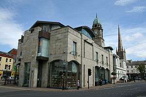 Irish Linen Museum and Christ Church Cathedral |
|
 Lisburn |
|
| Population | 120,465 surrounding areas |
|---|---|
| – Belfast | 8 miles |
| District | Lisburn and Castlereagh |
| County | County Antrim County Down |
| Country | Northern Ireland |
| Sovereign state | United Kingdom |
| Post town | LISBURN |
| Postcode district | BT27 BT28 |
| Dialling code | 028 |
| Police | Northern Ireland |
| Fire | Northern Ireland |
| Ambulance | Northern Ireland |
| EU Parliament | Northern Ireland |
| UK Parliament | Lagan Valley |
| NI Assembly | Lagan Valley |
| Website | http://www.lisburn.gov.uk |
|
|
Coordinates: 54°30′43″N 6°01′52″W / 54.512°N 6.031°W
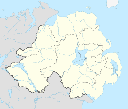
Lisburn (/ˈlɪz.bərn/ or /ˈlɪs.bərn/) is a city in Northern Ireland. It is 8 mi (13 km) southwest of Belfast, on the River Lagan, which forms the boundary between County Antrim and County Down. Lisburn forms part of the Belfast Metropolitan Area. It had a population of 71,465[1] people in the 2011 Census.[2]
Formerly a borough, Lisburn was granted city status in 2002 as part of Queen Elizabeth II's Golden jubilee celebrations. It is the third-largest city in Northern Ireland. Lisburn is one of the constituent cities that make up the Dublin-Belfast corridor region which has a population of just under 3 million.
Name
The town was originally known as Lisnagarvy (also spelt Lisnagarvey, Lisnegarvey, Lisnegarvy, Lisnegarvagh or Lisnagarvagh) after the townland in which it formed. This is derived from Irish Lios na gCearrbhach, meaning "ringfort of the gamesters/gamblers".[3]
The origin of the town's current name is uncertain. The modern spelling Lisburn first appears in a January 1662 entry in church records. After February 1662, the name Lisnagarvy is no longer found in the records.[4] It is commonly believed that the town was renamed after being burnt during the Irish Rebellion of 1641.[5] In his book Lisburn Cathedral and Its Past Rectors (1926), Reverend WP Carmody argues "This seems to be most improbable; after twenty years the burning would be a memory, and the loyal people of the town would not be disposed to give it a name that would be forever reminiscent of its destruction by rebels".[4] There is evidence that the name existed even at the time of the rebellion. In the depositions concerning the rebellion, an English soldier stated on 9 June 1653 that the rebels entered the town of Lisnagarvy at "a place called Louzy Barne".[4][6] Carmody believes that, in the town's early days, there were two co-existing ringforts: Lisnagarvy to the north and Lisburn to the south. He suggests that both names come from Irish and concludes: "Lisburn, being shorter and more easily pronounced by the English settlers, became the familiar name and Lisnagarvey gradually dropped out".[4]
The original name is still used in the titles of some local schools and sports teams.
History
Lisburn's original site was a fort located north of modern-day Wallace Park.[7] In 1609 James I granted Sir Fulke Conway, a Welshman of Norman descent,[8][9] the lands of Killultagh in southwest County Antrim. During the 1620s the streets of Lisburn were laid out just as they are today: Market Square, Bridge Street, Castle Street and Bow Street. Conway brought over many English and Welsh settlers during the Ulster Plantation; he also had a manor house built on what is now Castle Gardens, and in 1623, a church on the site of the current cathedral. In 1628, Sir Edward Conway, brother to the now deceased Sir Fulke, obtained a charter from King Charles I granting the right to hold a weekly market. This is still held in the town every Tuesday.[10] The Manor House was destroyed in the accidental fire of 1707 and was never rebuilt; the city's Latin motto, Ex igne resurgam ("Out of the fire I shall arise"), is a reference to this incident.

Lisburn is also known as the birthplace of Ireland's linen industry, which was established in 1698 by Louis Crommelin and other Huguenots. An exhibition about the Irish linen industry is now housed in the Irish Linen Centre, which can be found in the old Market House in Market Square.[11]
In 1920, disturbances related to the ongoing Irish War of Independence saw almost all of Lisburn's Catholic businesses burned out and many of the town's Catholic population forced to flee.[12] The town was one of the first to recruit special constables, who went on to become part of Northern Ireland's Ulster Special Constabulary.
The Cold War
Between 1954 and 1992 Lisburn contained the operational headquarters of No 31 Belfast Group Royal Observer Corps[13] who operated from a protected nuclear bunker on Knox Road within Thiepval Barracks. Converted from a 1940s Anti-aircraft Operations Room (AAOR), the bunker would support over one hundred ROC volunteers and a ten-man United Kingdom Warning and Monitoring Organisation warning team responsible for the four-minute warning in the event of a nuclear strike on the UK. The ROC would also have detected radioactive fallout from the nuclear bursts and warned the public of approaching fallout.
The two organisations were disbanded in 1992 at the end of the Cold War. In 2007 a commemorative plaque was mounted on the wall of the nuclear bunker which still stands, in recognition of the service of ROC volunteers in Northern Ireland.
The Troubles
Areas
North Lisburn
The north and south divide in Lisburn can be seen either side of the railway line that goes through the centre of the city. North Lisburn is home to many of the residential neighbourhoods, and contains the notable landmarks of the Theipval Barracks, and the Laurelhill Sportszone.
Administration
Lisburn is the administrative centre of Lisburn and Castlereagh City Council area,[14] which also includes Mazetown, Hillsborough, Moira, Dromara, Glenavy, Dunmurry and Drumbo.
.JPG)
In elections for the Westminster Parliament the city falls mainly into the Lagan Valley constituency but partly into West Belfast.
The headquarters of the British Army in Northern Ireland at Thiepval Barracks and the headquarters of the Northern Ireland Fire and Rescue Service are located in the city.
The councillors elected in the 2014 election for the city are:
| Name | Party | |
|---|---|---|
| Margaret Tolerton | DUP | |
| Scott Carson | DUP | |
| Jenny Palmer | DUP | |
| Alan Givan | DUP | |
| Paul Porter | DUP | |
| Andrew Ewing | DUP | |
| Rhoda Walker | DUP | |
| Brian Bloomfield | UUP | |
| Tim Mitchell | UUP | |
| Stephen Martin | Alliance | |
| Amanda Grehan | Alliance | |
| Johnny McCarthy | NI21 | |
Demography and education
| Historical population | ||
|---|---|---|
| Year | Pop. | ±% |
| 1821 | 4,684 | — |
| 1831 | 5,745 | +22.7% |
| 1841 | 6,284 | +9.4% |
| 1851 | 6,533 | +4.0% |
| 1861 | 7,462 | +14.2% |
| 1871 | 7,876 | +5.5% |
| 1881 | 10,755 | +36.6% |
| 1891 | 12,250 | +13.9% |
| 1901 | 11,461 | −6.4% |
| 1911 | 12,388 | +8.1% |
| 1926 | 12,406 | +0.1% |
| 1937 | 13,042 | +5.1% |
| 1951 | 14,781 | +13.3% |
| 1961 | 17,700 | +19.7% |
| 1966 | 21,522 | +21.6% |
| 1971 | 31,836 | +47.9% |
| 1981 | 82,091 | +157.9% |
| 1991 | 99,458 | +21.2% |
| 2001 | 108,694 | +9.3% |
| 2011 | 120,165 | +10.6% |
| Figures after 1971 are the census figures for Lisburn City Council, which covered a larger area than the former county borough.[15] | ||
Education
|
|
Churches
Lisburn is notable for its large number of churches, with 132 churches listed in the Lisburn City Council area.[16] One of two cathedrals in the Church of Ireland Diocese of Connor is in Lisburn, Christ Church Cathedral.
Transport
Rail
Lisburn railway station was opened on 12 August 1839.[17] The railway remains a popular means of transport between Lisburn and Belfast, with the express trains taking 10–15 minutes to reach Belfast's Great Victoria Street. The train also links the city directly with Newry, Portadown, Lurgan, Moira and Bangor. The station also has services to Dublin Connolly in the city of Dublin, with three trains per day stopping at the station. All railway services from the station are provided by Northern Ireland Railways, a subsidiary of Translink. The city is also served by Hilden railway station.

Bus
- Ulsterbus provides various bus services that connect the city with Belfast city centre, which lies eight miles northeast. These services generally operate either along Belfast's Lisburn Road or through the Falls area in west Belfast. In addition to long-distance services to Craigavon, Newry and Banbridge, there is also a network of buses that serve the rural areas around the city, such as Glenavy and Dromara; as well as an hourly bus service 6am-6pm Monday-Saturday to Belfast International Airport.
- The city has a vast network of local buses, serving the local housing developments and amenities. These are operated by Ulsterbus.[18]
- A new Bus Centre, provided by the regional public transport provider Translink, opened on 30 June 2008 at the corner of Smithfield Street and the Hillsborough Road. It replaced the shelters that formerly stood in Smithfield Square.[19]

Road
The city has a favourable position on the Belfast-Dublin corridor, being connected with the former by the M1 motorway from which it can be accessed through junctions 3, 6, 7 and 8. The A1 road to Newry and Dublin deviates from the M1 at the Sprucefield interchange, which is positioned one mile southeast of the city centre. An inner orbital route was formed throughout the 1980s which has permitted the city centre to operate a one-way system as well as the pedestrianisation of the Bow Street shopping precinct.[20] In addition to this, a feeder road leading from Milltown on the outskirts of Belfast to Ballymacash in north Lisburn, was opened in 2006. This route connects with the A512 and permits traffic from Lisburn to easily access the M1 at junction 3 (Dunmurry) thus relieving pressure on the southern approaches to the city.[21]
Inland Waterways
The Lagan Canal passes through Lisburn. This connected the port of Belfast to Lough Neagh, reaching Lisburn in 1763 (although the full route to Lough Neagh was not complete until 1793). Prior to World War II the canal was an important transportation route for goods, averaging over 307,000 tons of coal per year in the 1920s. Following competition from road transport, the canal was formally closed to navigation in 1958, and grew derelict. A short stretch and lock in front of Lisburn Council offices was restored to use in 2001.[22]
Shopping

Lisburn has become one of the main towns/cities in Northern Ireland for shopping.
Bow Street Mall, on Bow Street, houses over 70 stores, many eateries (including a food court) and a multi-storey car park with over 1000 spaces. The nearby pedestrianised city centre has numerous local independent shops such as McCalls of Lisburn, Smyth Patterson & Greens Foodfare, as well as many national and high street fashion stores. Lisburn Square, located off Bow Street, is an almost outdoor shopping centre. It houses many high street stores as well as bars, restaurants and cafes.
Sprucefield Shopping Centre and Sprucefield Retail Park are two large retail parks located about 2 minutes from the city centre. The first of its kind in Northern Ireland, it has become very popular with residents from all over Northern Ireland, and from as far away as Dublin. This is mainly due to its favourable position on the Belfast-Dublin corridor. It houses many warehouse type stores including B&Q, Toys'R'Us and Marks and Spencer.
Communications
The local area code, like the rest of Northern Ireland is 028. However all local 8-digit subscriber numbers are found in the form 92xx-xxxx. Before the Big Number Change in 2000, the STD code for Lisburn and its surrounding area was 01846, having previously been 0846.
Climate
As with the rest of the British Isles, Lisburn experiences a maritime climate with cool summers and mild winters. The nearest official Met Office weather station for which online records are available is at Hillsborough,[23] about 3 miles south south west of the city centre.
Averaged over the period 1971–2000 the warmest day of the year at Hillsborough will reach 24.3 °C (75.7 °F),[24] although 9 out of 10 years should record a temperature of 25.1 °C (77.2 °F) or above.[25]
Averaged over the same period, the coldest night of the year typically falls to −6.0 °C (21.2 °F)[26] and on 37 nights air frost was observed.[27]
Typically annual rainfall falls just short of 900 mm, with at least 1 mm falling on 154 days of the year.[28]
| Climate data for Hillsborough 116 m asl, 1971–2000, Extremes 1960–2005 (Weather Station 3.0 Miles SSW of Lisburn) | |||||||||||||
|---|---|---|---|---|---|---|---|---|---|---|---|---|---|
| Month | Jan | Feb | Mar | Apr | May | Jun | Jul | Aug | Sep | Oct | Nov | Dec | Year |
| Record high °C (°F) | 14.7 (58.5) |
15.8 (60.4) |
19.4 (66.9) |
22.8 (73) |
23.8 (74.8) |
28.1 (82.6) |
29.5 (85.1) |
28.4 (83.1) |
24.5 (76.1) |
21.1 (70) |
15.8 (60.4) |
14.5 (58.1) |
29.5 (85.1) |
| Average high °C (°F) | 6.9 (44.4) |
7.1 (44.8) |
8.9 (48) |
10.9 (51.6) |
14.0 (57.2) |
16.4 (61.5) |
18.3 (64.9) |
18.0 (64.4) |
15.5 (59.9) |
12.4 (54.3) |
9.2 (48.6) |
7.6 (45.7) |
12.1 (53.78) |
| Average low °C (°F) | 1.4 (34.5) |
1.6 (34.9) |
2.6 (36.7) |
3.5 (38.3) |
5.8 (42.4) |
8.6 (47.5) |
10.8 (51.4) |
10.6 (51.1) |
8.9 (48) |
6.5 (43.7) |
3.4 (38.1) |
2.2 (36) |
5.49 (41.88) |
| Record low °C (°F) | −12.2 (10) |
−7.8 (18) |
−10.0 (14) |
−4.9 (23.2) |
−3.3 (26.1) |
0.0 (32) |
2.5 (36.5) |
1.8 (35.2) |
−1.2 (29.8) |
−4.5 (23.9) |
−8.3 (17.1) |
−11.5 (11.3) |
−12.2 (10) |
| Average precipitation mm (inches) | 88.87 (3.4988) |
61.65 (2.4272) |
68.23 (2.6862) |
58.03 (2.2846) |
59.44 (2.3402) |
62.45 (2.4587) |
57.9 (2.28) |
77.89 (3.0665) |
79.98 (3.1488) |
91.85 (3.6161) |
84.72 (3.3354) |
91.03 (3.5839) |
882.04 (34.7264) |
| Source: [29] | |||||||||||||
Health care
The main hospital in the city is the Lagan Valley Hospital, which provides Accident and Emergency services to the area. The hospital lost its acute services in 2006. Residents now must travel to Belfast for acute surgery. The Lagan Valley lost its 24-hour A&E from 1 August 2011 due to a shortage of Junior Doctors. It will now instead be open 9am-8pm and will be closed on weekends. This has caused much controversy as residents of the city will now have to travel to Belfast or Craigavon.[30] Primary care in the area is provided by the Lisburn Health Centre, which opened in 1977.[31] The city lies within the South Eastern Health and Social Care Board area, formerly known as Down and Lisburn Trust.
Sport
In November 2012 the Award of 2013 European City of Sport was officially handed over to Lisburn at a presentation ceremony at the European Parliament in Brussels.
Football
- Lisburn Distillery is an association football club playing in the NIFL Championship and based at Ballyskeagh, on the outskirts of the city.
- Ballymacash Rangers F.C. play in the Mid-Ulster Football League.
- Lisburn Rangers F.C. play in the Northern Amateur Football League.
- Downshire Young Men F.C. play in the Northern Amateur Football League.
- Warren Young Men
- Ballymacash Young Men F.C.
- Lambeg Rangers F.C.
- FC United Lisburn
- South Antrim F.C.
- 1st Lisburn F.C.
- The city remains a key centre for youth football, hosting most games in the 'Lisburn Junior Invitational League', an amateur youth league which incorporates many teams from across the east of Ulster.
Other sports
- Lisburn Basketball Club
- Lisburn Cricket Club
- Lisburn Racquets Club
- Lisburn Taekwando Club
- St. Patrick's GAA
- Down Royal racecourse is located near the city
- SMCC Lisburn (Saturday Morning Cycling Club)
People
- Sir Richard Wallace created baronet in 1871 and was Member of Parliament for Lisburn from 1873 to 1885.
- David Trimble[32] lives within the city.
- Senior Ulster Defence Association leader John McMichael (1948–1987) was a native of Lisburn.
- Linguist, academic and author David Crystal OBE was born in Lisburn in 1941.
- Richard Dormer, Actor.
- Damien Johnson, Northern Irish international footballer was born here.
- Singer-songwriter Duke Special was born in Lisburn in 1971.
- Mary Peters lives in Lisburn.
- Barry Fitzgerald was born in Lisburn in 1972.
- Jonny Ross, Northern Irish bowler from Lisburn.
- Henry Munro (United Irishman)
- Sam Cree playwright.
- Anna Cheyne 1926–2002 Artist and sculptor long time resident of Lisburn.
- Donna Traynor. Journalist born in Lisburn.
- Sir John Milne Barbour, 1st Baronet JP, DL (1868–1951) a Northern Irish politician and baronet.
- John Doherty Barbour JP DL (1824–1901) Irish industrialist and politician.
- Lillian Margaret Metge (1871–1954) Militant suffragette, who bombed Lisburn Cathedral in 1914, lived here[33]
- John Grubb Richardson (1813–1891) Irish linen merchant, industrialist and philanthropist who founded the model village of Bessbrook
- William H. Conn (1895–1973) was an Irish cartoonist, illustrator, watercolourist and poster artist.
- Samuel McCloy (1831–1904) was an Irish painter
- John Jeffers (1822–1890) member of the Wisconsin State Assembly
- Kristian Nairn, portrayed Hodor in Game Of Thrones
See also
References
- ↑ The City of Lisburn 2009 - 20010 (PDF). Lisburn City Council.
- ↑ "Census 2011: Population and Household Estimates by Local Government District for Northern Ireland" (PDF). Northern Ireland Statistics and Research Agency. September 2012. Retrieved 16 September 2016.
- ↑ Placenames NI
- 1 2 3 4 Carmody, W. P. "Lisburn Cathedral – Lisburn.com".
- ↑ Placenames Database of Ireland (see archival records)
- ↑ http://www.kco.ie, Kco Ltd. -. "1641 Depositions". Trinity College Dublin.
- ↑ http://www.lisburnmuseum.com/collections/origins-name-lisburn-lios-na-gcearrbhach-lisnagarvey-mean/
- ↑ "Land of Linen and the Lambeg Drum – Lisburn.com". James & Darryl Collins.
- ↑ "Glenavy Past and Present – Lisburn.com". James & Darryl Collins.
- ↑ Hanna, John (2002). Old Lisburn. Catrine, Ayrshire: Stenlake Publishing. p. 3. ISBN 978-1-84033-227-8.
- ↑ "Lisburn City Council: Irish Linen Centre and Lisburn Museum". City of Lisburn.
- ↑ "Reprisals against Catholics in Lisburn and environs, July–August 1920". History Ireland. 5 March 2013.
- ↑ "Subbrit:RSG:ROC: Group HQ's". Subterranea Britannica.
- ↑ Office of Public Sector Information
- ↑ http://www.nisranew.nisra.gov.uk/census and http://www.histpop.org for post 1821 figures, 1813 estimate from Mason’s Statistical Survey For a discussion on the accuracy of pre-famine census returns see J. J. Lee "On the accuracy of the pre-famine Irish censuses Irish Population, Economy and Society edited by J. M. Goldstrom and LA Clarkson (1981) p54, in and also New Developments in Irish Population History, 1700–1850 by Joel Mokyr and Cormac Ó Gráda in The Economic History Review, New Series, Vol. 37, No. 4 (Nov 1984), pp. 473–488.
- ↑ "List of churches on Lisburn.com".
- ↑ "Lisburn station" (PDF). Railscot – Irish Railways. Retrieved 28 August 2007.
- ↑ Translink Service 325: "Lisburn City Service"
- ↑ Translink Press Release 16-Jun-2008: "Passengers to benefit from Brand New Lisburn Buscentre
- ↑ Planning Service: BMAP 2015. Transportation in Lisburn
- ↑ "North Lisburn Feeder Road – Northern Ireland Roads". Northern Ireland Books.
- ↑ "Lagan Canal Trust". Lagan Canal Trust.
- ↑ "Station Locations". MetOffice.
- ↑ ">1971–2000 average warmest day". Retrieved 23 September 2011.
- ↑ ">25c days". Retrieved 23 September 2011.
- ↑ ">average coldest night". Retrieved 22 September 2011.
- ↑ ">air frost incidence". Retrieved 23 September 2011.
- ↑ ">Wet days". Retrieved 23 September 2011.
- ↑ "Climatology maps".
- ↑ Smyth, Lisa (27 July 2011). "Fury as Lagan Valley Hospital A&E shuts at night". Belfast Telegraph.
- ↑ "Health and Wealth in the Borough of Lisburn. By E.J.Best". Lisburn Historical Society (Vol. 2). Archived from the original on 25 October 2006. Retrieved 1 August 2008.
- ↑ UK Parliament Web Site
- ↑ "Mrs Metge and the Bombing of Lisburn Cathedral | Lisburn Museum". www.lisburnmuseum.com. Retrieved 2016-09-16.
External links
| Wikimedia Commons has media related to Lisburn. |
| Wikivoyage has a travel guide for Lisburn. |
- Lisburn at DMOZ
- Lisburn.com directory of shops & services with extensive history of the city.
| Large |  | |
|---|---|---|
| Medium | ||
| Small | ||
Italics denote settlements that are classed as towns but also have city status | ||
