Glens of Antrim

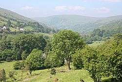
The Glens of Antrim,[1] known locally as simply The Glens, is a region of County Antrim, Northern Ireland. It comprises nine glens (valleys), that radiate from the Antrim Plateau to the coast. The Glens are an area of outstanding natural beauty and are a major tourist attraction in north Antrim. The main towns and villages in the Glens are Ballycastle, Cushendun, Cushendall, Waterfoot, Carnlough and Glenarm. The Glens are mentioned in the song "Ireland's Call".
The Lordship of the Glens, from the mid-13th century, first belonged to the Scoto-Irish Norman Bissett family. In the mid-16th century it came into the ownership of the MacDonnells of Antrim.
The nine glens from northernmost to southernmost are:
| Irish name | Meaning | Ref | |
|---|---|---|---|
| Glentaisie | Gleann Taise | Taise's valley/damp valley | [1][2] |
| Glenshesk | Gleann Seisc | barren valley | [1] |
| Glendun | Gleann Doinne | valley of the [river] Dun | [1][2] |
| Glencorp | Gleann Corp | valley of the body | [1] |
| Glenaan | Gleann Athain | valley of the burial chamber | [2][3] |
| Glenballyeamon | Gleann Bhaile Uí Dhíomáin Gleann Bhaile Éamainn |
valley of Ó Dhíomáin's town valley of Éamonn's town |
[1][2] |
| Glenariff | Gleann Aireamh | valley of the ploughman/arable valley | [1][3] |
| Glencloy | Gleann Claidheamh | valley of the sword | [1] |
| Glenarm | Gleann Arma | valley of the army | [1][3] |
Glenravel is sometimes considered a tenth glen. It lies to the southwest of Glenballyeamon and Glenariff, being separated from the latter by the Glenariff forest park. The main settlements of Glenravel are Cargan, Martinstown and Skerry (Newtowncrommelin).
Archaeology

In the Glens there is evidence of Neolithic communities. At Glencloy, Neolithic people had megalithic tombs in the uplands, while they lived in settlements near the coast at the end of the valley. The beaches were sources of flint, as evidenced by stone tool (lithic) production sites in the glens. At Madman's Window (near Glenarm) Neolithic chipping floors and stone axe rough outs were found along with Neolithic pottery, scrapers, flakes, and leaf-shaped arrowheads. At Bay Farm in Carnlough, a Neolithic site near marshland, archaeologists found occupation debris, charcoal, postholes, flint cores, axes and Neolithic pottery.[4]
See also
References
- 1 2 3 4 5 6 7 8 9 Logainm.ie (Placenames Database of Ireland)
- 1 2 3 4 Moyle District Council Area, Northern Ireland Place-Name Project, Queen's University Belfast
- 1 2 3 Place Names NI
- ↑ O'Sullivan, Aidan; Breen, Colin (2007). Maritime Ireland. An Archaeology of Coastal Communities. Stroud: Tempus. p. 63. ISBN 978-0-7524-2509-2.
External links
| Wikimedia Commons has media related to Glens of Antrim. |
- Glens of Antrim Website
- Glens of Antrim Historical Society
- Children's short story set in the Antrim Glens
- Landscapes Unlocked - Aerial footage from the BBC Sky High series explaining the physical, social and economic geography of Northern Ireland.
Coordinates: 55°09′36″N 6°06′00″W / 55.16000°N 6.10000°W