Roadstown, New Jersey
| Roadstown, New Jersey | |
|---|---|
| Unincorporated community | |
 Roadstown, New Jersey  Roadstown, New Jersey  Roadstown, New Jersey | |
| Coordinates: 39°26′27″N 75°19′06″W / 39.44083°N 75.31833°WCoordinates: 39°26′27″N 75°19′06″W / 39.44083°N 75.31833°W | |
| Country |
|
| State |
|
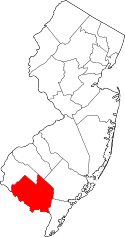
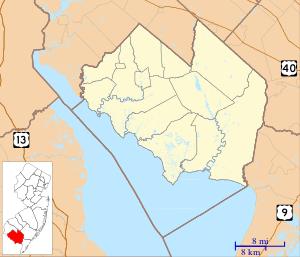
| County | Cumberland |
| Township | Stow Creek |
| Elevation | 35 m (115 ft) |
| Time zone | Eastern (EST) (UTC-5) |
| • Summer (DST) | EDT (UTC-4) |
| GNIS feature ID | 879728[1] |
Roadstown is an unincorporated community located within Stow Creek Township, in Cumberland County, New Jersey, United States.[1][2]
Roadstown is located at the intersection of County Route 620 and 626, approximately 3 mi (4.8 km) southwest of Shiloh.
History
Prior to the American Revolution, Roadstown was considered an important settlement in the region. Roadstown was then known as "Sayre's Cross-Roads" or "Sayre's Corners", named for Ananias Sayre, "a leading citizen" and county sheriff.[1][3]
Maskell Ware settled in Roadstown in 1789, where he worked as a farmer and manufacturer of hand-made chairs.[4] Ware chairs are today considered collectors items.[5]
The Cohansey Baptist Church relocated to Roadstown in 1802. Established in 1683, it is today the third oldest Baptist church in New Jersey.[6][7]
A post office was established in 1803.[8]
In 1834, Roadstown had a tavern, two stores, 20 dwellings, and "was peopled principally by the cultivators of the soil".[9] By 1882, the population had grown to 200.[10]
Notable people
- Harris Flanagin, 7th Governor of Arkansas.[11]
- Charles Elmer Hires, inventor of root beer and namesake of Hires Root Beer. Lived in Roadstown as a child, and may have been born there.[12]
References
- 1 2 3 U.S. Geological Survey Geographic Names Information System: Roadstown
- ↑ Locality Search, State of New Jersey. Accessed December 30, 2014.
- ↑ Elmer, Lucius Quintus Cincinnatus (1869). History of the Early Settlement and Progress of Cumberland County, New Jersey: And of the Currency of this and Adjoining Colonies. George F. Nixon. p. 16.
- ↑ Dependahl Waters, Deborah (1979). "Wares and Chairs: A Reappraisal of the Documents". American Furniture and Its Makers. University of Chicago Press. 13: 161–173.
- ↑ Resnik, Virginia M. (July 2, 1987). "The Hands that Hold an Old Craft". philly.com.
- ↑ "Cohansey Baptist Church at Roadstown". Cumberland County. Retrieved December 2014. Check date values in:
|access-date=(help) - ↑ Mollick, Sharon. "Mapping the Dead" (PDF). Cumberland County Department of Planning & Development. Retrieved December 2014. Check date values in:
|access-date=(help) - ↑ "Hopewell Township" (PDF). Hopewell Township. 1998.
- ↑ Gordon, Thomas Francis (1834). The History of New Jersey: From Its Discovery by Europeans, to the Adoption of the Federal Constitution. D. Fenton. p. 227.
- ↑ Edwards, Richard Edwards (1882). Industries of New Jersey: Essex County Including City of Newark. Historical Publishing Company. p. 120.
- ↑ "Arkansas Governor Harris Flanagin". National Governors Association. Retrieved December 2014. Check date values in:
|access-date=(help) - ↑ Bennett, Eileen (June 28, 1998). "Local Historians Argue Over the Root of the Story of How Hires First Brewed Beer that Made Millions". Cumberland County.