RH postcode area

Postcode district boundaries: Bing / Google

KML is from Wikidata
Redhill postcode area
RH
Postcode area RH
Postcode area name Redhill
Post towns 17
Postcode districts 21
Postcode sectors 89
Postcodes (live) 15,856
Postcodes (total) 22,668
Statistics as at February 2012[1]

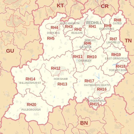
The RH postcode area, also known as the Redhill postcode area,[2] is a group of twenty postcode districts in East Surrey and North Sussex, which are subdivisions of eight post towns.

The main sorting office is in Crawley (Gatwick Mail Centre), and the area served includes parts of the Surrey districts of Guildford, Mole Valley, Reigate and Banstead and Tandridge, as well as most of the West Sussex districts of Crawley, Chichester, Horsham and Mid Sussex, and small parts of the East Sussex districts of Lewes and Wealden.

Coverage

The approximate coverage of the postcode districts:

Postcode district Post town Coverage Local authority area
RH1 REDHILL Redhill, Merstham, Earlswood, South Earlswood, Whitebushes, Salfords, Nutfield, Nutfield Marsh, South Nutfield, Bletchingley, Outwood Reigate and Banstead, Tandridge
RH2 REIGATE Reigate, Woodhatch, South Park, Skimmington, Leigh, Dawes Green, Bunce Common, Shellwood Cross, Nalderswood, Sidlow, Irons Bottom Reigate and Banstead, Mole Valley
RH3 BETCHWORTH Betchworth, Brockham, Buckland, Strood Green, Gadbrook Mole Valley
RH4 BETCHWORTH[3] Betchworth (far west) Mole Valley
DORKING Dorking, Pixham, Westcott
RH5 DORKING Abinger, Capel, Westhumble, Mickleham, Ockley, Holmbury St Mary Mole Valley, Guildford
RH6 GATWICK Gatwick Airport Crawley
HORLEY Horley, Burstow Reigate and Banstead, Crawley, Mole Valley, Tandridge
RH7 LINGFIELD Lingfield, Dormansland, Crowhurst Tandridge
RH8 OXTED Oxted, Limpsfield, Limpsfield Chart, Hurst Green, Merle Common, Tandridge, Crowhurst Lane End Tandridge
RH9 GODSTONE Godstone, South Godstone Tandridge
RH10 CRAWLEY Copthorne, Crawley Down, Domewood, Furnace Green, Northgate, Maidenbower, Pound Hill, Rowfant, Southgate, Three Bridges, Tilgate Crawley, Mid Sussex
RH11 CRAWLEY Bewbush, Broadfield, Gossops Green, Ifield, Langley Green, Lowfield Heath, Pease Pottage, Southgate West, West Green Crawley, Mid Sussex, Horsham
RH12 HORSHAM Horsham, Broadbridge Heath, Rusper, Rudgwick, Warnham Horsham
RH13 HORSHAM Barns Green, Cowfold, Mannings Heath, Partridge Green, Slinfold, Southwater, West Grinstead Horsham
RH14 BILLINGSHURST Billingshurst, Ifold, Kirdford, Loxwood, Plaistow, Wisborough Green Chichester, Horsham
RH15 BURGESS HILL Burgess Hill, Ditchling Common Mid Sussex, Lewes
RH16 HAYWARDS HEATH Haywards Heath, Lindfield Mid Sussex
RH17 HAYWARDS HEATH Ansty, Ardingly, Balcombe, Bolney, Chelwood Gate, Cuckfield, Danehill, Handcross, Hickstead, Horsted Keynes, Wivelsfield, Wivelsfield Green Mid Sussex, Lewes, Wealden
RH18 FOREST ROW Forest Row Wealden
RH19 EAST GRINSTEAD East Grinstead, Ashurst Wood, Dormans Park, Felbridge, Felcourt, Sharpthorne, West Hoathly Mid Sussex, Tandridge
RH20 PULBOROUGH Pulborough, Ashington, Storrington, West Chiltington, West Chiltington Common, Bury, Watersfield, Sutton, Fittleworth Chichester, Horsham
RH77 REDHILL Jobcentre Plus non-geographic

Map

KML is from Wikidata
RH postcode area map, showing postcode districts, post towns and neighbouring postcode areas. BN postcode area BR postcode area CR postcode area GU postcode area KT postcode area PO postcode area PO postcode area SM postcode area TN postcode area
RH postcode area map, showing postcode districts in red and post towns in grey text, with links to nearby BN, CR, GU, KT and TN postcode areas.

See also

References

  1. "ONS Postcode Directory Version Notes" (ZIP). National Statistics Postcode Products. Office for National Statistics. February 2012. Table 2. Retrieved 21 April 2012. Coordinates from mean of unit postcode points, "Code-Point Open". OS OpenData. Ordnance Survey. February 2012. Retrieved 21 April 2012.
  2. Royal Mail, Address Management Guide, (2004)
  3. "New sectors and localities to 21 September 2012" (PDF). Royal Mail Address Management Unit. 21 September 2012. Retrieved 24 September 2012.

External links

This article is issued from Wikipedia - version of the 8/24/2016. The text is available under the Creative Commons Attribution/Share Alike but additional terms may apply for the media files.