SM postcode area
Postcode district boundaries: Bing / Google
| Sutton postcode area | |
|---|---|
 SM | |
| Postcode area | SM |
| Postcode area name | Sutton |
| Post towns | 5 |
| Postcode districts | 7 |
| Postcode sectors | 29 |
| Postcodes (live) | 4,424 |
| Postcodes (total) | 6,357 |
| Statistics as at February 2012[1] | |
The SM postcode area, also known as the Sutton postcode area,[2][3] is a group of seven postcode districts in England which are subdivisions of five post towns. These postcode districts cover part of south-west London, as well as a small part of north Surrey.
The main sorting office is in Sutton, with outgoing mail being sorted at Croydon Mail Centre, and the area served includes most of the London Borough of Sutton, while most of SM4 covers the southwestern part of the London Borough of Merton and most of SM7 and a small part of SM2 cover the northern part of the borough of Reigate and Banstead in Surrey. SM2 also covers the village of East Ewell in the borough of Epsom and Ewell.
Although the official explanation for the M in the postcode is unknown, reference can be made to either Morden, one of the post towns situated within the area, or the London Borough of Merton, though Merton proper and much of the borough bar Morden and Mitcham is within the London SW postcode area.
Coverage
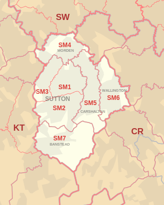
The approximate coverage of the postcode districts:[2]
| Postcode district | Post town | Coverage | Local authority area |
|---|---|---|---|
| SM1 | SUTTON | Sutton, Rosehill, Parts of The Wrythe and Carshalton, Benhilton and Erskine Village, the eastern part of Sutton Common | Sutton |
| SM2 | SUTTON | Belmont, South Sutton, South Cheam, East Ewell | Epsom and Ewell, Reigate and Banstead, Sutton |
| SM3 | SUTTON | The western part of Sutton Common, North Cheam, Stonecot Hill | Sutton |
| SM4 | MORDEN | Morden, Morden Park, Lower Morden, St. Helier (West), Rosehill | Merton, Sutton |
| SM5 | CARSHALTON | Carshalton, Carshalton Beeches, Carshalton on the Hill, The Wrythe, Rosehill, St. Helier (South), Middleton Circle, Little Woodcote | Sutton |
| SM6 | WALLINGTON | Wallington, Beddington, Hackbridge, Roundshaw | Sutton |
| SM7 | BANSTEAD | Banstead, Woodmansterne, Nork, Little Woodcote | Reigate and Banstead, Sutton |
Map

See also
References
- ↑ "ONS Postcode Directory Version Notes" (ZIP). National Statistics Postcode Products. Office for National Statistics. February 2012. Table 2. Retrieved 21 April 2012. Coordinates from mean of unit postcode points, "Code-Point Open". OS OpenData. Ordnance Survey. February 2012. Retrieved 21 April 2012.
- 1 2 Address Management Guide (5th ed.). Royal Mail Group plc. March 2007. Retrieved 28 October 2012.
- ↑ Office for National Statistics (1999). The Official Yearbook of the United Kingdom (PDF) (2000 ed.). London: The Stationery Office. "UK Postal Areas", map opposite p. 5. ISBN 0-11-621098-2. Retrieved 28 October 2012.