ML postcode area

Postcode district boundaries: Bing / Google

KML is from Wikidata
Motherwell postcode area
ML
Postcode area ML
Postcode area name Motherwell
Post towns 12
Postcode districts 12
Postcode sectors 55
Postcodes (live) 9,544
Postcodes (total) 11,250
Statistics as at February 2012[1]

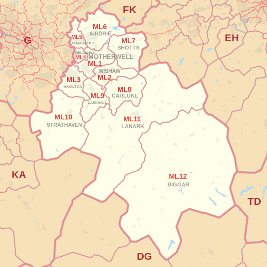
The ML postcode area, also known as the Motherwell postcode area,[2] is a group of postcode districts around Airdrie, Bellshill, Biggar, Carluke, Coatbridge, Hamilton, Lanark, Larkhall, Motherwell, Shotts, Strathaven, Newmains and Wishaw in Scotland.

Coverage

The approximate coverage of the postcode districts:

Postcode district Post town Coverage Local authority area
ML1 MOTHERWELL Motherwell, Carfin, Cleland, Hareshaw, Holytown, New Stevenston, Newarthill, Newhouse North Lanarkshire
ML2 WISHAW Wishaw, Bonkle, Bogside, Garrion Bridge, Morningside, Overtown, Waterloo, Newmains North Lanarkshire, South Lanarkshire
ML3 HAMILTON Hamilton, Ferniegair, Limekilnburn, Quarter South Lanarkshire, North Lanarkshire
ML4 BELLSHILL Bellshill, Orbiston, Mossend North Lanarkshire
ML5 COATBRIDGE Coatbridge, Annathill, Glenboig North Lanarkshire
ML6 AIRDRIE Airdrie, Calderbank, Caldercruix, Chapelhall, Forrestfield, Gartness, Glenmavis, Greengairs, Plains, Riggend, Stand, Wattston North Lanarkshire
ML7 SHOTTS Shotts, Allanton, Eastfield, Harthill, Hartwood, Salsburgh, Greenrigg North Lanarkshire, West Lothian
ML8 CARLUKE Carluke, Kilncazdow, Law South Lanarkshire
ML9 LARKHALL Larkhall, Netherburn, Stonehouse, Ashgill South Lanarkshire
ML10 STRATHAVEN Strathaven, Caldermill, Chapelton, Drumclog, Glassford, Sandford, Gilmourton, West Dykes Farm South Lanarkshire
ML11 LANARK Lanark, Auchenheath, Blackwood, Coalburn, Crossford, Hazelbank, Kirkfieldbank, Kirkmuirhill, Lesmahagow South Lanarkshire
ML12 BIGGAR Biggar, Broughton, Symington, Wanlockhead South Lanarkshire, Scottish Borders, Dumfries and Galloway

Map

KML is from Wikidata
ML postcode area map, showing postcode districts, post towns and neighbouring postcode areas. DG postcode area DG postcode area EH postcode area FK postcode area G postcode area KA postcode area PA postcode area PA postcode area TD postcode area
ML postcode area map, showing postcode districts in red and post towns in grey text, with links to nearby DG, EH, FK, G, KA and TD postcode areas.

See also

References

  1. "ONS Postcode Directory Version Notes" (ZIP). National Statistics Postcode Products. Office for National Statistics. February 2012. Table 2. Retrieved 21 April 2012. Coordinates from mean of unit postcode points, "Code-Point Open". OS OpenData. Ordnance Survey. February 2012. Retrieved 21 April 2012.
  2. Royal Mail, Address Management Guide, (2004)

External links

This article is issued from Wikipedia - version of the 8/24/2016. The text is available under the Creative Commons Attribution/Share Alike but additional terms may apply for the media files.