LU postcode area

Postcode district boundaries: Bing / Google

KML is from Wikidata
Luton postcode area
LU
Postcode area LU
Postcode area name Luton
Post towns 3
Postcode districts 8
Postcode sectors 36
Postcodes (live) 6,265
Postcodes (total) 9,841
Statistics as at February 2012[1]

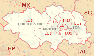
The LU postcode area, also known as the Luton postcode area,[2] is a group of seven postcode districts in England, which are subdivisions of three post towns. These postcode districts cover south Bedfordshire, as well as small parts of Hertfordshire and Buckinghamshire.

Coverage

The Luton post town forms a group of four postcode districts in the east, occupying approximately a third of the total area. The Dunstable post town forms a central strip of two postcode districts, extending from north to south. Leighton Buzzard forms the largest post town in the west, corresponding to a single postcode district.

The approximate coverage of the postcode districts:[3]

Postcode district Post town Coverage Local authority area
LU1 LUTON Luton (South), Aley Green, Caddington, Lower Woodside, Pepperstock, Skimpot, Slip End, Woodside Luton, Central Bedfordshire
LU2 LUTON Luton (East), Chiltern Green, Cockernhoe, East Hyde, Lawrence End, Lilley, New Mill End, Peters Green, Tea Green, The Hyde, Wandon End, Wandon Green, Winch Hill Luton, Central Bedfordshire, North Hertfordshire
LU3 LUTON Luton (North), Lower Sundon, Streatley, Sundon Luton, Central Bedfordshire
LU4 LUTON Luton (West), Chalton, Leagrave Luton, Central Bedfordshire
LU5 DUNSTABLE Dunstable (East including Woodside Estate), Bidwell, Chalgrave, Fancott, Harlington, Houghton Regis (including Townsend Industrial Estate), Thorn, Toddington Central Bedfordshire,
LU6 DUNSTABLE Dunstable (West), Eaton Bray, Edlesborough, Holywell, Kensworth, Northall, Sewell, Studham, Totternhoe, Whipsnade Central Bedfordshire, Aylesbury Vale
LU7 LEIGHTON BUZZARD Leighton Buzzard, Bragenham, Briggington, Burcott, Cheddington, Chelmscote, Clipstone, Crafton, Cublington, Eggington, Great Billington, Grove, Heath and Reach, Hockliffe, Horton, Hollingdon, Ivinghoe, Ivinghoe Aston, Ledburn, Leedon, Little Billington, Mentmore, Pitstone, Slapton, Soulbury, Stanbridge, Stewkley, Stockgrove, Tebworth, Tilsworth, Wing, Wingfield Central Bedfordshire, Aylesbury Vale

Previously, Perry Green was used as the locality in the LU2 postal addresses of some properties in Peters Green. Old Linslade was used in the LU7 addresses of Old Linslade, but these now include the words Heath and Reach.[4]

Map

KML is from Wikidata
LU postcode area map, showing postcode districts, post towns and neighbouring postcode areas. AL postcode area HP postcode area MK postcode area SG postcode area
LU postcode area map, showing postcode districts in red and post towns in grey text, with links to nearby AL, HP, MK and SG postcode areas.

See also

References

  1. "ONS Postcode Directory Version Notes" (ZIP). National Statistics Postcode Products. Office for National Statistics. February 2012. Table 2. Retrieved 21 April 2012. Coordinates from mean of unit postcode points, "Code-Point Open". OS OpenData. Ordnance Survey. February 2012. Retrieved 21 April 2012.
  2. Royal Mail, Address Management Guide, (2004)
  3. Placenames as listed in Royal Mail, Postal Address Book: Anglia 2, Edition H, 2003.
  4. Royal Mail, 'Postcodes', The Thomson Directory: Luton, Dunstable, Leighton Buzzard Area, 1992.

External links

This article is issued from Wikipedia - version of the 10/20/2016. The text is available under the Creative Commons Attribution/Share Alike but additional terms may apply for the media files.