Quebec City
| Quebec | |||
|---|---|---|---|
| City | |||
| Québec | |||
 | |||
| |||
| Nickname(s): "La Vieille Capitale"[1] | |||
|
Motto: Don de Dieu feray valoir ("I shall put God's gift to good use"; the Don de Dieu was Champlain's ship) | |||
_Quebec_location_diagram.png) Location (red) within Quebec TE (white) | |||
 Quebec Location of Quebec City in Quebec | |||
| Coordinates: 46°49′N 71°13′W / 46.817°N 71.217°WCoordinates: 46°49′N 71°13′W / 46.817°N 71.217°W[2] | |||
| Country |
| ||
| Province |
| ||
| Region | Capitale-Nationale | ||
| Metropolitan community | Communauté métropolitaine de Québec | ||
| Agglomeration | Agglomeration of Quebec City | ||
| Founded | 3 July 1608, by Samuel de Champlain | ||
| Constituted | 1 January 2002 | ||
| Boroughs | |||
| Government[3] | |||
| • Type | Quebec City Council | ||
| • Mayor | Régis Labeaume | ||
| • MPs |
List of MPs
| ||
| • MNAs |
List
| ||
| Area[3][4] | |||
| • City | 484.10 km2 (186.91 sq mi) | ||
| • Land | 454.10 km2 (175.33 sq mi) | ||
| • Metro[5] | 3,349.12 km2 (1,293.10 sq mi) | ||
| Elevation[6] | 98 m (322 ft) | ||
| Population (2015) | |||
| • City | 540,994[7] (10th) | ||
| • Density | 1,137.7/km2 (2,947/sq mi) | ||
| • Metro | 806,400 [8] (7th) | ||
| • Metro density | 228.6/km2 (592/sq mi) | ||
| • Pop 2006-2011 |
| ||
| Time zone | EST (UTC−5) | ||
| • Summer (DST) | EDT (UTC−4) | ||
| Postal code(s) | G1A to G2N | ||
| Area code(s) | 418 and 581 | ||
| Website |
www | ||

Quebec City (French: Ville de Québec) (pronounced ![]() i/kwᵻˈbɛk//kəˈbɛk/;[9] French: Québec [kebɛk]), officially Québec in both Canadian English and French,[10][11] is the capital of the province of Quebec in Canada. In 2015 the city had a population of 540,994,[12] and the metropolitan area had a population of 806,400,[13] making it Canada's seventh-largest metropolitan area and Quebec's second-largest city after Montreal, which is about 260 kilometres (160 mi) to the southwest, respectively. Quebec is the second-largest French-speaking city in Canada after Montreal.
i/kwᵻˈbɛk//kəˈbɛk/;[9] French: Québec [kebɛk]), officially Québec in both Canadian English and French,[10][11] is the capital of the province of Quebec in Canada. In 2015 the city had a population of 540,994,[12] and the metropolitan area had a population of 806,400,[13] making it Canada's seventh-largest metropolitan area and Quebec's second-largest city after Montreal, which is about 260 kilometres (160 mi) to the southwest, respectively. Quebec is the second-largest French-speaking city in Canada after Montreal.
According to the Government of Canada, the Government of Quebec, the Commission de toponymie du Québec, and the Geographical Names Board of Canada, the names of Canadian cities and towns have only one official form. Thus, Québec is officially spelled with an accented é in both Canadian English and French,[14][15][16] although the accent is often not used in common English usage. In English, the city and the province are formally distinguished by the fact that the province does not have an accented é while the city does, while informally the form "Quebec City" is frequently (although unofficially) used to distinguish the city from the province. In French, the names of the province and the city are distinguished grammatically in that the province takes the definite article (le Québec, du Québec, au Québec, respectively 'the Quebec', 'from the Quebec', 'in the Quebec') and the city does not (Québec, de Québec, à Québec, respectively 'Quebec City', 'from Quebec City', 'in Quebec City').
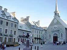
The narrowing of the Saint Lawrence River proximate to the city's promontory, Cap-Diamant (Cape Diamond), and Lévis, on the opposite bank, provided the name given to the city, Kébec, an Algonquin word meaning "where the river narrows". Founded in 1608 by Samuel de Champlain, Quebec City is one of the oldest cities in North America. The ramparts surrounding Old Quebec (Vieux-Québec) are the only fortified city walls remaining in the Americas north of Mexico, and were declared a World Heritage Site by UNESCO in 1985 as the 'Historic District of Old Québec'.[17][18]
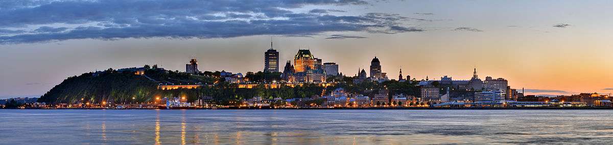
The city's famous landmarks include the Château Frontenac, a hotel which dominates the skyline, and La Citadelle, an intact fortress that forms the centrepiece of the ramparts surrounding the old city. The National Assembly of Quebec (provincial legislature), the Musée national des beaux-arts du Québec (National Museum of Fine Arts of Quebec), and the Musée de la civilisation (Museum of Civilization) are found within or near Vieux-Québec.
History
Early history
Quebec City is one of the oldest European settlements in North America. While many of the major cities in Latin America date from the sixteenth century, among cities in Canada and the U.S., few were created earlier than Quebec City (St. John's, Harbour Grace, Port Royal, St. Augustine, Santa Fe, Jamestown, and Tadoussac). Also, Quebec's Old Town (Vieux-Québec) is the only North American fortified city north of Mexico whose walls still exist.[19]

French explorer Jacques Cartier built a fort at the site in 1535, where he stayed for the winter before going back to France in spring 1536. He came back in 1541 with the goal of building a permanent settlement. This first settlement was abandoned less than one year after its foundation, in the summer 1542, due in large part to the hostility of the natives combined with the harsh living conditions during winter.
Quebec was founded by Samuel de Champlain, a French explorer and diplomat on 3 July 1608,[20] and at the site of a long abandoned St. Lawrence Iroquoian settlement called Stadacona. Champlain, also called "The Father of New France", served as its administrator for the rest of his life.
The name "Canada" refers to this settlement. Although called the cradle of the Francophone population in North America, the Acadian settlement at Port-Royal was established three years earlier. The place seemed favourable to the establishment of a permanent colony.
In 1629 there was the surrender of Quebec, without battle, to English privateers led by David Kirke during the Thirty Years' War.[21] However, Samuel de Champlain argued that the English seizing of the lands was illegal as the war had already ended; he worked to have the lands returned to France. As part of the ongoing negotiations of their exit from the Anglo-French War, in 1632 the English king Charles agreed to return the lands in exchange for Louis XIII paying his wife's dowry.[21] These terms were signed into law with the Treaty of Saint-Germain-en-Laye. The lands in Quebec and Acadia were returned to the French Company of One Hundred Associates.[21]
In 1665, there were 550 people in 70 houses living in the city. One-quarter of the people were members of religious orders: secular priests, Jesuits, Ursulines nuns and the order running the local hospital, Hotel-Dieu.[22]
Quebec City was the headquarters of many raids against New England during the four French and Indian Wars. In the last war, the French and Indian War (Seven Years' War), Quebec City was captured by the British in 1759 and held until the end of the war in 1763. It was the site of three battles during Seven Years' War - the Battle of Beauport, a French victory (31 July 1759); the Battle of the Plains of Abraham, in which British troops under General James Wolfe defeated the French General Louis-Joseph de Montcalm on 13 September 1759 and shortly thereafter took the city; and the final Battle of Sainte-Foy, a French victory (28 April 1760). France ceded New France, including the city, to Britain in 1763.[23]
At the end of French rule in 1763, forests, villages, fields and pastures surrounded the town of 8,000 inhabitants. The town distinguished itself by its monumental architecture, fortifications, affluent homes of masonry and shacks in the suburbs of Saint-Jean and Saint-Roch. Despite its urbanity and its status as capital, Quebec City remained a small colonial city with close ties to its rural surroundings. Nearby inhabitants traded their farm surpluses and firewood for imported goods from France at the two city markets.
British rule
During the American Revolution revolutionary troops from the southern colonies assaulted the British garrison in an attempt to 'liberate' Quebec City, in a conflict now known as the Battle of Quebec. The defeat of the revolutionaries from the south put an end to the hopes that the peoples of Quebec would rise and join the American Revolution so that Canada would join the Continental Congress and become part of the original United States of America along with the other British colonies of continental North America. In effect, the outcome of the battle would be the effective split of British North America into two distinct political entities. The city itself was not attacked during the War of 1812, when the United States again attempted to annex Canadian lands. Fearing another American attack on Quebec City in the future, construction of the Citadelle of Quebec began in 1820. The Americans never did attack Canada after the War of 1812, but the Citadelle continued to house a large British garrison until 1871. The Citadelle is still in use by the military and is also a tourist attraction.
In 1840, the role of capital was shared between Kingston, Montreal, Toronto, Ottawa and Quebec City (from 1852 to 1856 and from 1859 to 1866).
Long before the Royal Military College of Canada was established in 1876, there were proposals for military colleges in Canada. Staffed by British Regulars, adult male students underwent a 3 month long military course in Quebec City in 1864 at the School of Military Instruction in Quebec City. Established by Militia General Order in 1864, the school enabled Officers of Militia or Candidates for Commission or promotion in the Militia to learn Military duties, drill and discipline, to command a Company at Battalion Drill, to Drill a Company at Company Drill, the internal economy of a Company and the duties of a Company's Officer.[24] The school was retained at Confederation, in 1867. In 1868, The School of Artillery was formed in Montreal.[25]
In 1867, Ottawa (which was chosen to be the permanent capital of the Province of Canada) was chosen by Queen Victoria to be the capital of the Dominion of Canada. The Quebec Conference on Canadian Confederation was held here.
20th and 21st centuries

Quebec City was struck by the 1925 Charlevoix–Kamouraska earthquake.
During World War II, two conferences were held in Quebec City. The First Quebec Conference was held in 1943 with Franklin Delano Roosevelt (the United States' president at the time), Winston Churchill (the United Kingdom's prime minister), William Lyon Mackenzie King (Canada's prime minister) and T.V. Soong (China's minister of foreign affairs). The Second Quebec Conference was held in 1944, and was attended by Churchill and Roosevelt. They took place in the buildings of the Citadelle and at the nearby Château Frontenac. A large part of the D-Day landing plans were made during those meetings.
Capital
Throughout its over 400 years of existence, Quebec City has served as a capital. From 1608 to 1627 and 1632 to 1763, it was capital of French Canada and all of New France; from 1763 to 1791, it was the capital of the Province of Quebec; from 1791 to 1841, it was the capital of Lower Canada; from 1852 to 1856 and from 1859 to 1866, it was capital of the Province of Canada; and since 1867, it has been capital of the Province of Quebec. The administrative region in which Quebec City is situated is officially referred to as Capitale-Nationale,[26][27] and the term "national capital" is used to refer to Quebec City itself at provincial level.[28]
Geography
Quebec City is located in the Saint Lawrence River valley, on the north bank of the Saint Lawrence River near its meeting with the St. Charles River. The surrounding area is low-lying and flat. The river valley has rich, arable soil, which makes this region the most fertile in the province. The Laurentian Mountains lie to the north of the city.
A portion of the city, as well as most of the Old Quebec area, is built on a plateau sometimes called the promontory of Quebec. Because of this topographic feature, the central and oldest area of the city is sometimes divided into upper and lower town.[29] On the eastern end of the hill, upper Town lies on the top of Cap-Diamant (Cape Diamond) promontory. The Plains of Abraham are located near the edge of the promontory, on which high stone walls have been integrated during colonial days. On the other hand, lower town is located on the eastern foot of this plateau. It has been a working class area for most of its history unlike uptown, which for the most part, quickly became a place of choice for the local middle-class and bourgeoisie.[30]
Climate
The climate of Quebec City is classified as humid continental (Köppen climate classification Dfb).[31]
Quebec City experiences four distinct seasons. Summers are warm and occasionally hot, with periods of hotter temperatures which compounded with the high humidity, create a high heat index that belie the average high of 22–25 °C (72–77 °F) and lows of 11–13 °C (52–55 °F). Winters are often cold, windy and snowy with average high temperatures −5 to −8 °C (23 to 18 °F) and lows −13 to −18 °C (9 to 0 °F). Spring and fall, although short, bring chilly to warm temperatures. Late heat waves as well as "Indian summers" are a common occurrence.
On average, Quebec City receives 1,190 millimetres (46.85 in) of precipitation, of which 899 millimetres (35.39 in) is rain and 303 millimetres (11.93 in) is the melt from 316 centimetres (124.4 in) of snowfall per annum.[note 1] The city experiences around 1,916 hours of bright sunshine annually or 41.5% of possible sunshine, with summer being the sunniest, but also slightly the wettest season. During winter, snow generally stays on the ground from the end of November till mid-April.
The highest temperature ever recorded in Quebec City was 36.1 °C (97 °F) on 17 July 1953.[32] The coldest temperature ever recorded was −36.7 °C (−34 °F) on 10 January 1890 and 14 January 2015.[33][34]
| Climate data for Quebec City (Jean Lesage International Airport), 1981−2010 normals, extremes 1875−present[lower-alpha 1] | |||||||||||||
|---|---|---|---|---|---|---|---|---|---|---|---|---|---|
| Month | Jan | Feb | Mar | Apr | May | Jun | Jul | Aug | Sep | Oct | Nov | Dec | Year |
| Record high humidex | 10.6 | 11.7 | 17.8 | 32.9 | 40.3 | 44.1 | 49.2 | 49.3 | 40.1 | 30.9 | 24.9 | 14.6 | 49.3 |
| Record high °C (°F) | 11.1 (52) |
11.7 (53.1) |
18.3 (64.9) |
29.9 (85.8) |
33.0 (91.4) |
34.4 (93.9) |
36.1 (97) |
35.6 (96.1) |
33.9 (93) |
28.3 (82.9) |
22.9 (73.2) |
15.0 (59) |
36.1 (97) |
| Average high °C (°F) | −7.9 (17.8) |
−5.6 (21.9) |
0.2 (32.4) |
8.3 (46.9) |
17.0 (62.6) |
22.3 (72.1) |
25.0 (77) |
23.6 (74.5) |
17.9 (64.2) |
11.1 (52) |
2.9 (37.2) |
−4.2 (24.4) |
9.2 (48.6) |
| Daily mean °C (°F) | −12.8 (9) |
−10.6 (12.9) |
−4.6 (23.7) |
3.7 (38.7) |
11.2 (52.2) |
16.4 (61.5) |
19.3 (66.7) |
18.1 (64.6) |
12.7 (54.9) |
6.6 (43.9) |
−0.7 (30.7) |
−8.6 (16.5) |
4.2 (39.6) |
| Average low °C (°F) | −17.7 (0.1) |
−15.6 (3.9) |
−9.4 (15.1) |
−1.0 (30.2) |
5.4 (41.7) |
10.5 (50.9) |
13.5 (56.3) |
12.5 (54.5) |
7.5 (45.5) |
2.0 (35.6) |
−4.2 (24.4) |
−12.8 (9) |
−0.8 (30.6) |
| Record low °C (°F) | −36.7 (−34.1) |
−36.1 (−33) |
−30.0 (−22) |
−18.9 (−2) |
−7.8 (18) |
−0.6 (30.9) |
3.9 (39) |
2.2 (36) |
−4.8 (23.4) |
−10.0 (14) |
−26.1 (−15) |
−35.6 (−32.1) |
−36.7 (−34.1) |
| Record low wind chill | −51.1 | −52.4 | −41.0 | −29.0 | −13.6 | 0.0 | 0.0 | 0.0 | −7.8 | −17.3 | −30.8 | −48.4 | −52.4 |
| Average precipitation mm (inches) | 86.6 (3.409) |
74.5 (2.933) |
76.1 (2.996) |
83.5 (3.287) |
115.9 (4.563) |
111.4 (4.386) |
121.4 (4.78) |
104.2 (4.102) |
115.5 (4.547) |
98.3 (3.87) |
102.5 (4.035) |
99.9 (3.933) |
1,189.7 (46.839) |
| Average rainfall mm (inches) | 22.7 (0.894) |
15.2 (0.598) |
30.2 (1.189) |
67.5 (2.657) |
115.9 (4.563) |
111.4 (4.386) |
121.4 (4.78) |
104.2 (4.102) |
115.5 (4.547) |
94.6 (3.724) |
69.1 (2.72) |
31.7 (1.248) |
899.3 (35.406) |
| Average snowfall cm (inches) | 71.9 (28.31) |
63.6 (25.04) |
46.4 (18.27) |
13.2 (5.2) |
0.0 (0) |
0.0 (0) |
0.0 (0) |
0.0 (0) |
0.0 (0) |
3.2 (1.26) |
32.7 (12.87) |
72.4 (28.5) |
303.4 (119.45) |
| Average precipitation days (≥ 0.2 mm) | 17.1 | 14.3 | 13.4 | 12.1 | 15.4 | 13.4 | 13.5 | 13.4 | 13.4 | 14.4 | 16.0 | 18.5 | 174.9 |
| Average rainy days (≥ 0.2 mm) | 3.0 | 2.4 | 4.7 | 10.4 | 15.3 | 13.4 | 13.5 | 13.4 | 13.4 | 14.1 | 10.1 | 4.5 | 118.2 |
| Average snowy days (≥ 0.2 cm) | 16.3 | 13.2 | 10.5 | 4.3 | 0.13 | 0.0 | 0.0 | 0.0 | 0.0 | 1.0 | 8.1 | 16.6 | 70.1 |
| Average relative humidity (%) | 67.8 | 64.6 | 60.7 | 55.9 | 51.6 | 56.0 | 59.1 | 59.1 | 61.8 | 63.1 | 70.4 | 73.2 | 61.9 |
| Mean monthly sunshine hours | 98.9 | 121.2 | 152.0 | 170.6 | 211.1 | 234.7 | 252.3 | 232.0 | 163.0 | 122.0 | 76.6 | 81.9 | 1,916.3 |
| Percent possible sunshine | 35.5 | 41.8 | 41.3 | 41.9 | 45.3 | 49.6 | 52.7 | 52.7 | 43.1 | 36.0 | 27.1 | 30.7 | 41.5 |
| Source: Environment Canada,[35][36][37] (Extremes 1875−1959)[38] | |||||||||||||
Parks and Gardens
Quebec city is home to over a hundred parks and gardens, which offer certain attractions like bird watching, hiking or canoeing for visitors.
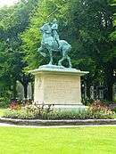
One of the most notable is The Battlefields Park, which is home to 50 historical artillery pieces and the Plains of Abraham. The park offers views of the St. Lawrence River and has multiple historical structures and statues like the Joan of Arc on Horseback and the Martello Towers.[39] Historically this was the site of an American revolutionary battle, the Battle of Quebec (1775) where the British were able to hold onto its last stronghold in the Northern extent of its North American territory.
Another notable park is the Parc du Bois-de-Coulonge, which is known for its gardens and bird watching, is the second largest urban park in Quebec City. The Parc du Bois-de-Coulonge[40] also has historical influence being the site of gardens that were created by British and French royalty. Quebec City's largest park is the Parc Chauveau, which offers a range of outdoor activities from hiking, canoeing and skiing. Other notable areas are Beauport bay, Domaine de Maizerets, Marais du Nord and Parc Cartier-Roberval.[39]
Boroughs and districts
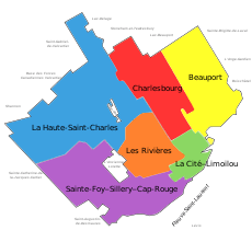
On 1 January 2002, the 12 former towns of Sainte-Foy, Beauport, Charlesbourg, Sillery, Loretteville, Val-Bélair, Cap-Rouge, Saint-Émile, Vanier, L'Ancienne-Lorette, Saint-Augustin-de-Desmaures and Lac-Saint-Charles were annexed by Quebec City. This was one of several municipal mergers which took place across Quebec on that date. Following a demerger referendum, L'Ancienne-Lorette and Saint-Augustin-de-Desmaures were reconstituted as separate municipalities on 1 January 2006, but the other former municipalities remain part of Quebec City. On 1 November 2009, the Quebec City re-organized its boroughs, reducing the number from 8 to 6.[41]

As of 2011 Quebec City has 35 districts in six boroughs. All districts are numbered, and most are named. In most cases the name of the district is similar to a historical town or village it replaced, but not always. Districts each elect their own council, which are part of public consultations with the city government. The numbering system was based on the 2002-2009 borough boundaries, so post-2009 the numbers do not correspond completely with the boroughs.
Compared to many other cities in North America, there is less variation between average household incomes between the districts. However, some disparities exist. Montcalm, Sillery, Cap-Rouge, and the southern part of Sainte-Foy are considered to be the wealthiest, along with all areas found west of Old Quebec along the banks of the Saint Lawrence River.
The cities traditional working class areas are found in the lower town below Old Quebec (Saint-Sauveur and Saint Roch) and directly across the Saint Charles River (Vanier and Limoilou). However, parts of Limoilou and particularly Saint Roch have seen gentrification in the last 20 years, attracting young professionals and the construction of new offices and condos.
The central part of the city consists of industrial areas while northern sections (Loretteville, Val Belair) and eastern sections (Beapourt, Charlesbourg) are mostly a mix of middle class residential suburbs.
| Borough | Districts |
| 1/6 La Cité-Limoilou | La Cité: 1-1 Vieux-Québec—Cap-Blanc—colline Parlementaire · 1-2 Saint-Roch · 1-3 Saint-Jean-Baptiste · 1-4 Montcalm · 1-5 Saint-Sauveur · 1-6 Saint-Sacrement · Limoilou: 6-1 Vieux-Limoilou · 6-2 Lairet · 6-3 Maizerets |
| 2 Les Rivières | 2-1 Neufchâtel-Est–Lebourgneuf · 2-2 Duberger-Les Saules · 2-3 Vanier |
| 3/8 Sainte-Foy–Sillery–Cap-Rouge | 3-2 Cité universitaire · 3-3 Saint-Louis · 3-4 Plateau · 3-5 Pointe-de-Ste-Foy 8-2 · L'Aéroport · 8-3 Cap-Rouge |
| 4 Charlesbourg | 4-1 Notre-Dame-des-Laurentides · 4-2 Quartier 4-2 · 4-3 Quartier 4-3 · 4-4 Jésuites, Quebec City · 4-5 Quartier 4-5 · 4-6 Quartier 4-6 |
| 5 Beauport | 5-1 Quartier 5-1 · 5-2 Quartier 5-2 · 5-3 Chutes-Montmorency · 5-4 Quartier 5-4 · 5-5 Vieux-Moulin |
| 7/8 La Haute-Saint-Charles | 7-1 Lac-Saint-Charles · 7-2 Saint-Émile · 7-3 Loretteville · 7-4 Des Châtels · 8-1 Val-Bélair |
Demographics
| Québec City | ||
|---|---|---|
| Year | Pop. | ±% |
| 1871 | 76,593 | — |
| 1881 | 80,249 | +4.8% |
| 1891 | 80,546 | +0.4% |
| 1901 | 88,615 | +10.0% |
| 1911 | 102,214 | +15.3% |
| 1921 | 122,698 | +20.0% |
| 1931 | 168,249 | +37.1% |
| 1941 | 199,588 | +18.6% |
| 1951 | 245,742 | +23.1% |
| 1956 | 279,521 | +13.7% |
| 1961 | 321,917 | +15.2% |
| 1966 | 372,373 | +15.7% |
| 1971 | 408,440 | +9.7% |
| 1976 | 429,757 | +5.2% |
| 1981 | 434,980 | +1.2% |
| 1986 | 440,598 | +1.3% |
| 1991 | 461,894 | +4.8% |
| 1996 | 473,569 | +2.5% |
| 2001 | 476,330 | +0.6% |
| 2006 | 491,142 | +3.1% |
| 2011 | 516,622 | +5.2% |
| [42] | ||
According to Statistics Canada, there were 540,994 [12] people residing in Quebec City proper, and 806,400 [13] people in the metropolitan area in 2015. Of the former total, 48.2% were male and 51.8% were female. Children under five accounted for approximately 4.7% of the resident population of Quebec City. This compares with 5.2% in the province of Quebec, and 5.6% for Canada overall.
The vast majority of city residents are native French speakers. The English-speaking community peaked in relative terms during the 1860s, when 40% of Quebec City's residents were Anglophone.[43][44] Today, Anglophones make up only 1.5% of the population of both the city and its metropolitan area.[45] However, the annual Quebec Winter Carnival attracts both Francophone and Anglophone tourists alike, so the Anglophone population increases considerably during the duration of the event.
According to the Statistics Canada website, 94.6% of Quebec City's population speaks French as their mother tongue. In addition, more than a third of city residents can speak both French and English.
| Mother tongue | Population | Percentage |
|---|---|---|
| French | 456,225 | 94.6% |
| English | 7,030 | 1.5% |
| English and French | 1,460 | 0.3% |
| Other languages | 17,825 | 3.7% |
| Unilingual French speakers | 315,135 | 65.3% |
| Unilingual English speakers | 835 | 0.2% |
| Bilingual French and English speakers | 165,340 | 34.3% |
In 2001, 13.0% of the resident population in Quebec City was of retirement age (65 and over for males and females) compared with 13.2% in Canada. The average age is 39.5 years of age compared to 37.6 years of age for Canada as a whole.
In the five years between 2006 and 2011, the population of Quebec City grew by 6.5%, compared with an increase of 4.9% for the province of Quebec. The population density of Quebec City averaged 228.6 inhabitants per square kilometre (592/sq mi), compared with an average of 5.3/km2 (14/sq mi) for the province as a whole.
At the time of the 2001 census, the population of the Quebec City authority was 682,757, but was 710,700 when encompassing the Greater Quebec City Area, compared with a resident population in the province of Quebec of 7,237,479 people.
In 2006, visible minorities made up 3% of the city's population,[46] which is the smallest proportion of any major Canadian city. There has, however, been a growing number of new arrivals from North and West Africa, as well as Latin America, who have settled in the city. Recent arrivals tend to be more concentrated in Limoilou, Vanier and the northern part of Sainte-Foy, where the availability of lower cost apartments is higher than the rest of the city
According to the 2001 census, over 90% of the population was Roman Catholic. The city also contains small Protestant, Muslim and Jewish communities.
Economy

Most jobs in Quebec City are concentrated in public administration, defence, services, commerce, transport and tourism. As the provincial capital, the city benefits from being a regional administrative and services centre: apropos, the provincial government is the largest employer in the city, employing 27,900 people as of 2007.[47] CHUQ (the local hospital network) is the city's largest institutional employer, with more than 10,000 employees in 2007. In 2008, the unemployment rate in Quebec City was 4.5%,[48] well below provincial and national averages (7.3% and 6.6%, respectively).[49]
Around 10% of jobs are in manufacturing.[50] Principal products include pulp and paper, processed food, metal/wood items, chemicals, electronics and electrical equipment, and printed materials. The city hosts the headquarters of a variety of prominent companies, including: fashion retailer La Maison Simons, engineering firms BPR and Roche Ltd, Consulting Group; investment fund Cominar; Industrial Alliance, La Capitale, Promutuel, SSQ Financial Group, and Union Canadienne in the insurance sector; Beenox, Gearbox Software, Frima Studio, Sarbakan and Ubisoft in the computer games industry; AeternaZentaris and DiagnoCure in pharmaceuticals; Amalgame, Cossette and Vision 7 in marketing and advertising; Institut National d'Optique (INO), EXFO, OptoSecurity in technology not forgetting the Desjardins Group, the area's largest employer in the financial sector.
The security and defence industries are quite prominent, and have given birth to an industrial pole: Technopôle Defence and Security.
Architecture
Much of the city's most notable architecture is located east of the fortification walls in Vieux-Québec (Old Quebec) and Place Royale. This area has a distinct European feel with its stone buildings and winding streets lined with shops and restaurants. Porte St-Louis and Porte St-Jean are the main gates through the walls from the modern section of downtown; the Kent Gate was a gift to the province from Queen Victoria and the foundation stone was laid by the Queen's daughter, Princess Louise, Marchioness of Lorne, on 11 June 1879.[51] West of the walls are the Parliament Hill district and the Plains of Abraham.
The Upper Town is linked by the Escalier « casse-cou » (literally "neck-breaking" steps) and the Old Quebec Funicular to the Lower Town, which includes such sites as the ancient Notre-Dame-des-Victoires church, the historic Petit Champlain district, the port, and the Musée de la Civilisation (Museum of Civilization). The Lower Town is filled with original architecture and street designs, dating back to the city's beginnings. Murals and statues are also featured. The Lower Town is also noted for its wide variety of boutiques, many featuring hand-crafted goods.

Quebec City's downtown is on the lower part of the town. Its epicentre is adjacent to the old town, spanning from the Saint-Roch district, throughout the Saint Sauveur, Saint-Sacrement and Limoilou quarters. Some interpretations consider Quebec's downtown to be the central southern portion of the town ranging from the old city and Saint Roch, all the way west to the Quebec city Bridge.
Quebec City's skyline is dominated by the massive Château Frontenac Hotel, perched on top of Cap-Diamant. It was designed by architect Bruce Price, as one of a series of "château" style hotels built for the Canadian Pacific Railway company. The railway company sought to encourage luxury tourism and bring wealthy travelers to its trains.
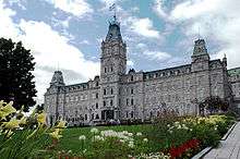
Alongside the Château Frontenac is the Terrasse Dufferin (Dufferin Terrace), a walkway along the edge of the cliff, offering beautiful views of the Saint Lawrence River. The Terrasse Dufferin leads toward the nearby Plains of Abraham, site of the battle in which the British took Quebec from France, and the Citadelle of Quebec, a Canadian Forces installation and the federal vice-regal secondary residence. The Parliament Building, the meeting place of the Parliament of Quebec, is also near the Citadelle.
Near the Château Frontenac is Notre-Dame de Québec Cathedral, mother church of the Roman Catholic Archdiocese of Quebec. It is the first church in the New World to be raised to a basilica and is the primatial church of Canada.
There are 37 National Historic Sites of Canada in Quebec City and its enclaves.[52]
Culture
Quebec City is known for its Winter Carnival, its summer music festival and for its Saint-Jean-Baptiste Day celebrations.
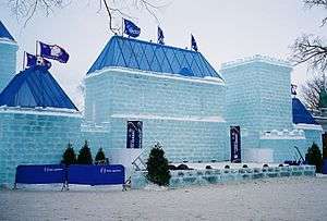
Tourist attractions located near Quebec City include Montmorency Falls, the Basilica of Sainte-Anne-de-Beaupré, the Mont-Sainte-Anne ski resort, and the Ice Hotel.
The Jardin zoologique du Québec, now closed, initially reopened in 2002 after extensive repairs before ultimately shuttering in 2006. It featured 750 specimens of 300 different species of animals. The zoo specialized in winged fauna and garden themes, but also featured several species of mammals. While it emphasized the indigenous fauna of Quebec, one of its main attractions was the Indo-Australian greenhouse, featuring fauna and flora from regions surrounding the Indian Ocean.

Parc Aquarium du Québec, which reopened in 2002 on a site overlooking the Saint Lawrence River, features more than 10,000 specimens of mammals, reptiles, fish and other aquatic fauna of North America and the Arctic. Polar bears and various species of seals of the Arctic sector and the "Large Ocean", a large basin offering visitors a view from underneath, make up part of the aquarium's main attractions.
There are a number of historic sites, art galleries and museums in Québec City, including Citadelle of Quebec, Musée national des beaux-arts du Québec, Ursulines of Quebec, and Musée de la civilisation.
Sports
As well as having a number of local sports teams, Quebec City has hosted a number of sporting events. The Special Olympics Canada National Winter Games was held in the city from 26 February to 1 March 2008.[53] Quebec City co-hosted with Halifax, Nova Scotia, the 2008 IIHF World Championship. Regular sporting events held in the city, include the Coupe Banque Nationale, a Women's Tennis Association tournament; Crashed Ice, an extreme downhill skating race; Quebec City International Pee-Wee Tournament, a minor hockey tournament; and the Tour de Québec International cycling stage race.[54]
In December 2011, Quebec City hosted the ISU Grand Prix of Figure Skating Final at the Pavillon de la Jeunesse at ExpoCité.
The city has a professional baseball team called the Capitales de Québec which plays in the Canadian American Association of Professional Baseball. The team was established in 1999, and originally played in the Northern League. The team has six league titles, won in 2006, 2009, 2010, 2011, 2012 and 2013. The team's stadium is the Stade Municipal.
Other teams include the local football team, the Rouge & Or of the Université Laval; the junior hockey team, Quebec Remparts of the Quebec Major Junior Hockey League; the Canadian football teams, Quebec City Monarks and Quebec City Rebelles of La Ligue de Football de Québec; the women's hockey team Quebec Phoenix of the Canadian Women's Hockey League; and soccer club Quebec Arsenal of the W-League.
The city had a hockey team, the Quebec Nordiques, which played in the World Hockey Association (WHA) from 1972 to 1979 and then in the National Hockey League (NHL) from 1979 to 1995, maintaining a strong rivalry with the Montreal Canadiens. Due to a disadvantageous exchange rate with respect to the US Dollar, the team moved to Denver, Colorado in 1995, becoming the Colorado Avalanche. The Quebec Remparts are a major junior team in the QMJHL and play in the Colisée Pepsi.
A professional basketball team, the Quebec Kebs played in National Basketball League of Canada in 2011 but folded prior to the start of the 2012 season.
The Videotron Centre has been built with the hope of getting an NHL franchise (relocation or expansion) in Quebec City.[55] The project was funded regardless of whether an NHL team arrives in Quebec City.[56] It is also hoped that the arena can help Quebec City win a future Winter Olympics games bid.[57] It will replace Colisée Pepsi as the main arena in Quebec City.

Government
The current mayor of Quebec City is Régis Labeaume. He was first elected in a special election on 2 December 2007, following the death in office of Andrée Boucher, and was subsequently re-elected in the municipal elections of 2009 and 2013. Jacques Joli-Coeur of the Renouveau municipal de Québec party served as interim mayor between Boucher's death and the by-election.
Quebec City is the seat of the judicial district of Québec, one of the province's 36 judicial districts.[58]
Education
The Université Laval (Laval University) is located in the western end of the city, in the borough of Sainte-Foy. However, the school of architecture of Université Laval is located at the "Vieux-Séminaire" building in Old Quebec. The main campus of the Université du Québec system is also located in Quebec City, including its specialized schools École nationale d'administration publique, Institut national de la recherche scientifique, and Télé-université (TELUQ), the distance learning component of the 'Université du Québec' network.
Numerous CEGEPs are located in Quebec city, including Collège François-Xavier-Garneau, Cégep O'Sullivan, Cégep Limoilou, Cégep de Sainte-Foy and Champlain College St. Lawrence, as well as private institutions such as Campus Notre-Dame-de-Foy, Collège Mérici, Collège Bart, Collège CDI and Collège Multihexa.
Quebec City has the oldest educational institution for women in North America, the Ursulines of Quebec monastery, located at 12 Rue Donnacona.
Infrastructure
Transportation

Roads
Two bridges (the Quebec Bridge and Pierre Laporte Bridge) and a ferry service connect the city with Lévis and its suburbs along the south shore of the Saint Lawrence River. The Orleans Island Bridge links Quebec City with pastoral Orleans Island.
Quebec City is an important hub in the province's autoroute system. Autoroute 40 connects the region with Montreal and Ottawa to the west and Sainte-Anne-de-Beaupré and the Charlevoix region to the east. Autoroute 20 parallels the south shore of the St. Lawrence River, linking Quebec City with Montreal and Toronto to the west and Rivière-du-Loup, Rimouski, and the Maritime Provinces to the east. Autoroute 73 provides a north-south link through the metropolitan area, linking it with Saint-Georges, the Beauce region, and Maine to the south and Saguenay and the Lac-Saint-Jean region to the north.
_-_Sud.JPG)
Within the metropolitan region, Autoroutes 40, 73, and several spur routes link the city centre with its suburbs.
Autoroute 573 (Autoroute Henri-IV) connects the city with CFB Valcartier. Autoroute 740 (Autoroute Robert-Bourassa) serves as a north-south inner belt. Autoroute 440 comprises two separate autoroutes to the west and east of the urban core. Originally meant to be connected by a tunnel under the city centre, the two sections are separated by a 6-kilometre (3.7 mi) gap. There are no current plans to connect them. The western section (Autoroute Charest) connects Autoroutes 40 and 73 with Boulevard Charest (a main east-west avenue) while the eastern section (Autoroute Dufferin-Montmorency) links the city centre with Beauport and Montmorency Falls.
Public transport
The Réseau de transport de la Capitale is responsible for public transport in the region. The RTC operates a fleet of buses and has recently implemented articulated buses. The RTC is studying the return of a tram and light rail system to help ease overcrowding on its busiest lines as well as attract new users to public transit. The two billion dollar revitalization project needs approval from higher levels of government since the city does not have the financial resources to fund such an ambitious project on its own.

Rail transport is operated by VIA Rail at the Gare du Palais ('Palace Station'). The station is the eastern terminus of the railway's main Quebec City-Windsor Corridor. An inter-city bus station, with connections to the provincial long-distance bus network, is adjacent to the train station, and hosts, among others, the services of Greyhound Canada and Orleans Express.
Air and sea
Quebec City is served by Jean Lesage International Airport (YQB), located at the city's western edge, 11 miles from the city center. According to U.S. standards, the airport is safe, well-managed and efficient with well-trained staff.[59]
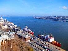
The city also has a major port on the St-Lawrence in the first, fifth and sixth boroughs.[60]
Public safety
Quebec City is protected by Service de police de la Ville de Québec and Service de protection contre les incendies de Québec. Quebec City has one of the lowest crime rates in Canada. The city reported no murders in 2007, a streak that stretched back to 31 October 2006.[61] Only two murders occurred in Quebec City in 2015. Gang recruitment has been recognized to be a federal crime in Bill C-394.[59]
Notable people
Partner cities
Quebec City is mainly twinned with Calgary and Bordeaux. It has other formal agreements with other cities although they are not active anymore as of 2012. These include Saint Petersburg, Guanajuato City, Hué and Liège and Namur in francophone Belgium.[62]
See also
References
- ↑ Marceau, Stéphane G.; Rémillard, François (2002). Ville de Québec (in French) (4th ed.). Montreal: Guides de voyage Ulysse. p. 14. ISBN 2-89464-510-4.
- ↑ Reference number 51718 of the Commission de toponymie du Québec (French)
- 1 2 Geographic code 23027 in the official Répertoire des municipalités (French)
- ↑ "(Code 2423027) Census Profile". 2011 census. Statistics Canada. 2012.
- ↑ "(Code 421) Census Profile". 2011 census. Statistics Canada. 2012.
- ↑ Québec City - The Canadian Encyclopedia
- ↑ http://www.mamrot.gouv.qc.ca/repertoire-des-municipalites/fiche/municipalite/23027/
- ↑ http://www.statcan.gc.ca/tables-tableaux/sum-som/l01/cst01/demo05a-eng.htm
- ↑ "Quebec". Oxford English Dictionary (3rd ed.). Oxford University Press. September 2005. (Subscription or UK public library membership required.)
- ↑ "Québec, City of Québec, Quebec City". Public Works and Government Services Canada. Retrieved 30 May 2015.
- ↑ "Place Names - Québec". Natural Resources Canada. Government of Canada. 2016.
- 1 2 Statistics Quebec
- 1 2 Population of census metropolitan areas
- ↑ "Québec, City of Québec, Quebec City". Public Works and Government Services Canada. 2016. Retrieved 29 October 2016.
- ↑ "Names (geographical)". Public Service Commission of Canada. Retrieved 29 October 2016.
- ↑ Government of Canada. "Geographical Names". The Canadian Style. Retrieved 29 October 2016.
- ↑ "Historic District of Old Québec". World Heritage; UNESCO. Retrieved 12 January 2009.
- ↑ "Old Quebec City, Seven Wonders of Canada". cbc.ca. Retrieved 12 February 2008.
- ↑ CBC.CA - Seven Wonders of Canada - Your Nominations - Old Quebec City, Quebec
- ↑ "View of Quebec, Capital of Canada". World Digital Library. Retrieved 11 February 2013.
- 1 2 3 "KIRKE, SIR DAVID, adventurer, trader, colonizer, leader of the expedition that captured Quebec in 1629, and later governor of Newfoundland", Dictionary of Canadian Biography Online
- ↑ Morison, Samuel Eliot (1972). The Oxford History of the American People. New York City: Mentor. p. 150. ISBN 0-451-62600-1.
- ↑ See Royal Proclamation I
- ↑ Anson Keill's Second class certificate from the School of Military Instruction, Kingston
- ↑ Richard Preston 'Canada's RMC: A History of the Royal Military College of Canada' published by the RMC Club by U of Toronto Press.
- ↑ Décret concernant la révision des limites des régions administratives du Québec, R.Q. c. D-11, r.2, made pursuant to the Territorial Division Act, R.S.Q. c. D-11
- ↑ "Québec Portal > Portrait of Québec > Administrative Regions > Regions". Retrieved 13 May 2009.
- ↑ "An Act respecting the National capital commission, R.S.Q. c. C-33.1". CanLII. 4 May 2009. Retrieved 13 May 2009.
- ↑ Geological Survey of Canada (1999). The 1988 Saguenay Earthquake - a Site Visit Report. p. 63.
- ↑ Stelter, Gilbert (1982). Shaping the Urban Landscape: Aspects of the Canadian City-Building Process. McGill Queen University Press.
- ↑ Peel, M. C. and Finlayson, B. L. and McMahon, T. A. (2007). "Updated world map of the Köppen–Geiger climate classification" (PDF). Hydrol. Earth Syst. Sci. 11: 1633–1644. doi:10.5194/hess-11-1633-2007. ISSN 1027-5606.
- ↑ "Daily Data Report for July 1953". Canadian Climate Data. Environment Canada. Retrieved 8 July 2016.
- ↑ "Daily Data Report for January 1890". Canadian Climate Data. Environment Canada. Retrieved 8 July 2016.
- ↑ "Daily Data Report for January 2015". Canadian Climate Data. Environment Canada. Retrieved 8 July 2016.
- ↑ "Quebec/Jean Lesage INT'L A, Quebec". Canadian Climate Normals 1981−2010. Environment Canada. Retrieved 8 May 2014.
- ↑ "QUEBEC/JEAN LESAGE INTL A". Environment Canada. Retrieved July 29, 2015.
- ↑ "QUEBEC/JEAN LESAGE INTL". Canadian Climate Data. Environment Canada. Retrieved 28 March 2016.
- ↑ "Quebec". Canadian Climate Data. Environment Canada. Retrieved 28 March 2016.
- 1 2 "Ville de Québec - Parks and Gardens". www.ville.quebec.qc.ca. Retrieved 2016-11-14.
- ↑ Québec, Office du tourisme de. "Parc du Bois-de-Coulonge". Official Web Site - Québec City Tourism. Retrieved 2016-11-14.
- ↑ Nouveau découpage des arrondissements (archive of broken link)
- ↑ "Évolution démographique des 10 principales villes du Québec (sur la base de 2116) selon leur limites territoriales actuelles1, Recensements du Canada de 1871 à 2011". Stat.gouv.qc.ca. Retrieved 2 January 2012.
- ↑ Morrin Centre. "Anglos in Québec". Literary and Historical Society of Quebec. Retrieved 15 March 2007.
- ↑ Blair, Louisa. The Anglos: The Hidden Face of Quebec City. Volume 1: 1608-1850; Volume 2: Since 1850. Québec: Commission de la capitale nationale du Québec & Éditions Sylvain Harvey, 2005.
- ↑ "Voice of English-speaking Québec: A Portrait of the English-speaking Community in Quebec". Voice of English-speaking Québec. 2007. Archived from the original on 29 September 2007. Retrieved 15 March 2007.
- ↑ http://www12.statcan.ca/census-recensement/2006/dp-pd/prof/92-591/details/page.cfm?Lang=E&Geo1=CSD&Code1=2423027&Geo2=PR&Code2=24&Data=Count&SearchText=quebec&SearchType=Begins&SearchPR=01&B1=All&Custom=
- ↑ "Canada's largest employers by city, 2007: Quebec City." London: University of Western Ontario. Retrieved 12 January 2009.
- ↑ "Labour: Labour force characteristics, population 15 years and older, by census metropolitan area."Statistics Canada. Retrieved 12 January 2009.
- ↑ "Latest release from the Labour Force Survey." Statistics Canada. Retrieved 12 January 2009.
- ↑ "Québec City: Economy, transportation, and labour force." The Canadian Encyclopedia. Historical Foundation of Canada, 2008. Retrieved 12 January 2009.
- ↑ Hubbard, R.H. (1977). Rideau Hall. McGill-Queen's University Press. p. 49. ISBN 978-0-7735-0310-6.
- ↑ The 37 sites in Quebec City are listed in the Directory of Federal Heritage Designations as being located in Québec and the following boroughs/enclaves: Beauport, Cap-Rouge, Notre-Dame-des-Anges, Sainte-Foy and Wendake.
- ↑ "History of Major Special Olympics Canada (SOC) Events" (PDF). Special Olympics Canada. 29 January 2007. Archived from the original (PDF) on 6 July 2011. Retrieved 14 July 2011.
- ↑ "Here comes the 4th Tour de Quebec!". tourdequebec.com. Retrieved 14 July 2011.
- ↑ Karine Gagnon, Qmi Agency (1 March 2011). "Quebecor joins arena plan, eyes NHL team | Hockey | Sports". Toronto Sun. Retrieved 2 January 2012.
- ↑ "The Quebec gravy train chugs off without Ottawa on board for once | Full Comment | National Post". Fullcomment.nationalpost.com. 2 March 2011. Archived from the original on 19 November 2011. Retrieved 2 January 2012.
- ↑ "Quebec City plans $400 million arena to attract NHL team, Winter Olympics — ESPN". Sports.espn.go.com. 16 October 2009. Retrieved 2 January 2012.
- ↑ Territorial Division Act. Revised Statutes of Quebec D-11.
- 1 2 "Canada 2016 Crime & Safety Report: Quebec City". www.osac.gov. Retrieved 2016-11-09.
- ↑ "Port of Quebec". Retrieved 24 June 2009.
- ↑ White, Marianne (28 December 2007). "Quebec City closing in on a year without murder". Nationalpost.com. Retrieved 14 July 2011.
- ↑ "Québec fait le ménage dans ses jumelages". Le Soleil (in French). 7 September 2012.
- "Faut-il traduire les toponymes?" [Should place names be translated?] (in French). Commission de toponymie du Québec. Retrieved 19 May 2012.
Notes
- ↑ Based on station coordinates provided by Environment Canada, climate data was recorded in the area of Old Quebec from August 1875 to February 1959, and at Jean Lesage International Airport from March 1943 to present.
Notes
- ↑ Although snow is measured in cm the melted snow (water equivalent) is measured in mm and added to the rainfall to obtain the total precipitation. An approximation of the water equivalent can be made by dividing the snow depth by ten. Thus 1 cm (0.4 in) of snow will be 1 mm (0.04 in) of water. See snow gauge, Rainfall, Snowfall, and Precipitation and MANOBS 7th Edition Amendment 17
External links
Multimedia
- CBC Television Archives on Preserving Quebec City (1976)
- CBC Digital Archives - Quebec City: 400 Years of History
 |
Shannon Ste-Catherine-de-la-Jacques-Cartier |
St-Gabriel-de-Valcartier, Lac-Delage, Stoneham-et-Tewkesbury, Lac-Beauport | Ste-Brigitte-de-Laval | |
| St-Augustin-de-Desmaures | |
Boischatel | ||
| ||||
| | ||||
| Saint Lawrence River / Lévis | Saint Lawrence River / Sainte-Pétronille |
| |
La Jacques-Cartier RCM | | ||
| Portneuf RCM | |
La Côte-de-Beaupré RCM | ||
| ||||
| | ||||
| Saint Lawrence River Lévis TE |
Saint Lawrence River L'Île-d'Orléans RCM |
| Boroughs |  | |
|---|---|---|
| Districts | ||
| Agglomeration | ||
| Enclaves | ||
| ||