Newfoundland and Labrador
| Newfoundland and Labrador | |||
|---|---|---|---|
| |||
|
Motto: "Quaerite prime regnum Dei" (Latin) "Seek ye first the kingdom of God" (Matthew 6:33) | |||
| Confederation | March 31, 1949 (12th) | ||
| Capital | St. John's | ||
| Largest city |
St. John's | ||
| Largest metro | St. John's metropolitan area | ||
| Government | |||
| • Type | Constitutional monarchy | ||
| • Lieutenant Governor | Frank Fagan | ||
| • Premier | |||
| Legislature | Newfoundland and Labrador House of Assembly | ||
| Federal representation | (in Canadian Parliament) | ||
| House seats | 7 of 338 (2.1%) | ||
| Senate seats | 6 of 105 (5.7%) | ||
| Area | |||
| • Total | 405,212 km2 (156,453 sq mi) | ||
| • Land | 373,872 km2 (144,353 sq mi) | ||
| • Water | 31,340 km2 (12,100 sq mi) 7.7% | ||
| Area rank | Ranked 10th | ||
| 4.1% of Canada | |||
| Population (2011) | |||
| • Total | 514,536 [2] | ||
| • Estimate (2016 Q1) | 528,336 [3] | ||
| • Rank | Ranked 9th | ||
| • Density | 1.4/km2 (4/sq mi) | ||
| Demonym(s) |
Newfoundlander | ||
| Official languages | English (de facto) | ||
| GDP | |||
| • Rank | 8th | ||
| • Total (2011) | C$33.624 billion[5] | ||
| • Per capita | C$65,556 (5th) | ||
| Time zone |
UTC−3.5 for Newfoundland UTC−4 for Labrador (Black Tickle and North) | ||
| Postal abbr. | NL (formerly NF) | ||
| Postal code prefix | A | ||
| ISO 3166 code | CA-NL | ||
| Flower |
| ||
| Tree |
| ||
| Bird |
| ||
| Website |
www | ||
| Rankings include all provinces and territories | |||

Newfoundland and Labrador (/njuːfənˈlænd ən ˈlæbrədɔːr/, French: Terre-Neuve-et-Labrador; Innu: Akamassiss), is the most easterly province of Canada. Situated in the country's Atlantic region, it comprises the island of Newfoundland and mainland Labrador to the northwest, with a combined area of 405,212 square kilometres (156,500 sq mi). In 2013, the province's population was estimated at 526,702.[6] About 92% of the province's population lives on the island of Newfoundland (and its neighbouring smaller islands), of whom more than half live on the Avalon Peninsula. The province is Canada's most linguistically homogeneous, with 97.6% of residents reporting English (Newfoundland English) as their mother tongue in the 2006 census.[7] Historically, Newfoundland was also home to unique varieties of French and Irish, as well as the extinct Beothuk language. In Labrador, local dialects of Innu-aimun and Inuktitut are also spoken.
Newfoundland and Labrador's capital and largest city, St. John's, is Canada's 20th-largest census metropolitan area, and is home to almost 40 percent of the province's population. St. John's is the seat of government, home to the House of Assembly of Newfoundland and Labrador and to the highest court in the jurisdiction, the Newfoundland and Labrador Court of Appeal.
A former colony then dominion of the United Kingdom, Newfoundland and Labrador became the tenth province to enter the Canadian Confederation on March 31, 1949, as "Newfoundland". On December 6, 2001, an amendment was made to the Constitution of Canada to change the province's official name to Newfoundland and Labrador.[8] In day-to-day conversation, however, Canadians generally still refer to the province itself as Newfoundland and that part of it on the Canadian mainland as Labrador.
Etymology
The name "Newfoundland" is a translation of the Portuguese Terra Nova, that is also reflected in the French name for the Province's island part (Terre-Neuve). The influence of early Portuguese exploration is also reflected in the name of Labrador, which derives from the surname of the Portuguese navigator João Fernandes Lavrador.[9]
Geography
Newfoundland and Labrador is the most easterly province in Canada, and is located at the north-eastern corner of North America.[10] The Strait of Belle Isle separates the province into two geographical divisions: Labrador, which is a large area of mainland Canada, and Newfoundland, an island in the Atlantic Ocean.[11] The province also includes over 7,000 tiny islands.[12] Newfoundland is roughly triangular. Each side is about 400 km (250 mi) long, and its area is 108,860 km2 (42,030 sq mi).[12] Newfoundland and its neighboring small islands (excluding French possessions) have a total area of 111,390 km2 (43,010 sq mi).[13] Newfoundland extends between latitudes 46°36′N and 51°38′N.[14][15]
Labrador is an irregular shape: the western part of its border with Quebec is the drainage divide of the Labrador Peninsula. Lands drained by rivers that flow into the Atlantic Ocean are part of Labrador, the rest belongs to Quebec. Most of Labrador's southern boundary with Quebec follows the 52nd parallel of latitude. Labrador's extreme northern tip, at 60°22′N, shares a short border with Nunavut. Labrador's area (including associated small islands) is 294,330 km2 (113,640 sq mi).[13] Together, Newfoundland and Labrador make up 4.06% of Canada's area.[16]
Labrador is the easternmost part of the Canadian Shield, a vast area of ancient metamorphic rock comprising much of northeastern North America. Colliding tectonic plates have shaped much of the geology of Newfoundland. Gros Morne National Park has a reputation as an outstanding example of tectonics at work,[17] and as such has been designated a World Heritage Site. The Long Range Mountains on Newfoundland's west coast are the northeasternmost extension of the Appalachian Mountains.[11]

The north-south extent of the province (46°36′N to 60°22′N), prevalent westerly winds, cold ocean currents and local factors such as mountains and coastline combine to create the various climates of the province.[18] Northern Labrador is classified as a polar tundra climate, southern Labrador has a subarctic climate, while most of Newfoundland has a humid continental climate (Dfb under the Köppen climate classification system): cool summer subtype.
Climate

Newfoundland and Labrador has a wide range of climates and weather,[19] due to its geography. The island of Newfoundland spans 5 degrees of latitude, comparable to the Great Lakes.[19] The province has been divided into six climate types, but broadly Newfoundland has a cool summer subtype of a humid continental climate, which is greatly influenced by the sea since no part of the island is more than 100 km (62 mi) from the ocean. Northern Labrador is classified as a polar tundra climate, southern Labrador has a subarctic climate.[20]
Monthly average temperatures, rainfall and snowfall for four places are shown in the attached graphs. St. John's represents the east coast, Gander the interior of the island, Corner Brook the west coast of the island and Wabush the interior of Labrador. Climate data for 56 places in the province is available from Environment Canada.[21] The data for the graphs is the average over thirty years. Error bars on the temperature graph indicate the range of daytime highs and night time lows. Snowfall is the total amount that fell during the month, not the amount accumulated on the ground. This distinction is particularly important for St. John's, where a heavy snowfall can be followed by rain, so that no snow remains on the ground.
Surface water temperatures on the Atlantic side reach a summer average of 12 °C (54 °F) inshore and 9 °C (48 °F) offshore to winter lows of −1 °C (30 °F) inshore and 2 °C (36 °F) offshore.[22] Sea temperatures on the west coast are warmer than Atlantic side by 1 to 3 °C (1 to 5 °F). The sea keeps winter temperatures slightly higher and summer temperatures a little lower on the coast than inland.[22] The maritime climate produces more variable weather, ample precipitation in a variety of forms, greater humidity, lower visibility, more clouds, less sunshine, and higher winds than a continental climate.[22]
| Location | July (°C) | July (°F) | January (°C) | January (°F) |
|---|---|---|---|---|
| St. John's | 20/11 | 68/52 | −1/−9 | 30/16 |
| Grand Falls-Windsor | 23/11 | 73/52 | –2/–12 | 27/9 |
| Gander | 21/11 | 71/51 | −3/−12 | 26/11 |
| Corner Brook | 22/13 | 71/55 | −3/−10 | 28/15 |
| Stephenville | 20/12 | 68/54 | −2/−9 | 27/15 |
| Fogo Island | 19/10 | 66/50 | –3/–9 | 26/16 |
| Labrador City | 19/8 | 66/47 | –16/–27 | 2/–18 |
| Happy Valley – Goose Bay | 21/10 | 69/50 | −12/−22 | 9/−8 |
| Nain | 15/5 | 59/41 | −14/−23 | 7/−10 |
 Newfoundland and Labrador average monthly temperatures |
 Newfoundland and Labrador average monthly rainfall |
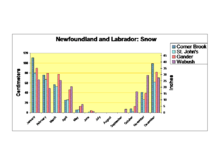 Newfoundland and Labrador average monthly snowfall |
History
Pre-colonisation

Human habitation in Newfoundland and Labrador can be traced back about 9,000 years.[24] The Maritime Archaic peoples were groups of Archaic cultures of sea-mammal hunters in the subarctic.[25] They prospered along the Atlantic Coast of North America from about 7000 BC to 1500 BC.[26] Their settlements included longhouses and boat-topped temporary or seasonal houses.[25] They engaged in long-distance trade, using as currency white chert, a rock quarried from northern Labrador to Maine.[27] The southern branch of these people was established on the north peninsula of Newfoundland by 5,000 years ago.[28] The Maritime Archaic period is best known from a mortuary site in Newfoundland at Port au Choix.[25]
The Maritime Archaic peoples were gradually displaced by people of the Dorset Culture (Late Paleo-Eskimo) who also occupied Port au Choix. The number of their sites discovered on Newfoundland indicates they may have been the most numerous group of Aboriginal people to live there. They thrived from about 2000 BC to AD 800. Many of their sites were located on exposed headlands and outer islands. They were more oriented to the sea than earlier peoples, and had developed sleds and boats similar to kayaks. They burned seal blubber in soapstone lamps.[28]
Many of these sites, such as Port au Choix, recently excavated by Memorial archaeologist, Priscilla Renouf, are quite large and show evidence of a long-term commitment to place. Renouf has excavated huge amounts of harp seal bones at Port au Choix, indicating that this place was a prime location for the hunting of these animals.[28]
The people of the Dorset Culture (800 BC – AD 1500) were highly adapted to living in a very cold climate, and much of their food came from hunting sea mammals through holes in the ice.[29] The massive decline in sea ice during the Medieval Warm Period would have had a devastating impact upon their way of life.[29]
The appearance of the Beothuk culture is believed to be the most recent cultural manifestation of peoples who first migrated from Labrador to Newfoundland around 1 AD.[30] The Inuit, found mostly in Labrador, are the descendants of what anthropologists call the Thule people, who emerged from western Alaska around AD 1000 and spread eastwards across the High Arctic, reaching Labrador around 1300–1500.[31] Researchers believe that the Dorset culture lacked the dogs, larger weapons and other technologies that gave the expanding Inuit people an advantage.[32] Over time, groups started to focus on resources available to them locally.
The inhabitants eventually organized themselves into small bands of a few families, grouped into larger tribes and chieftainships. The Innu are the inhabitants of an area they refer to as Nitassinan, i.e. most of what is now referred to as northeastern Quebec and Labrador. Their subsistence activities were historically centred on hunting and trapping caribou, deer and small game.[33] Coastal clans also practised agriculture, fished and managed maple sugar bush.[33] The Innu engaged in tribal warfare along the coast of Labrador with the Inuit groups that had significant populations.[34]
The Mi'kmaq of southern Newfoundland spent most of their time on the shores harvesting seafood; during the winter they would move inland to the woods to hunt.[35] Over time, the Mi'kmaq and Innu divided their lands into traditional "districts". Each district was independently governed and had a district chief and a council. The council members were band chiefs, elders and other worthy community leaders.[36] In addition to the district councils, the Mi'kmaq tribes also had (have) a Grand Council or Santé Mawiómi, which according to oral tradition was formed before 1600.[37]
Descendants of the Beothuks
By the time that European contact with Newfoundland began in the early 16th century, the Beothuk were the only indigenous group living permanently on the island.[30] Unlike other groups in the Northeastern area of the Americas, the Beothuk never established sustained trading relations with European settlers. Instead, their trading interactions were sporadic, and they largely attempted to avoid contact in order to preserve their culture.[38] The establishment of English fishing operations on the outer coastline of the island, and their later expansion into bays and inlets, cut off access for the Beothuk to their traditional sources of food. In the 18th century, as the Beothuk were driven further inland by these encroachments, violence between Beothuk and settlers escalated, with each retaliating against the other in their competition for resources. By the early 19th century, violence, starvation, and exposure to tuberculosis had decimated the Beothuk population, and they were extinct as a cultural group by 1829.[30]
Geneticists have suggested that some Icelanders may carry Beothuk DNA, which has been passed down matrilineally over the centuries. This suggests that when the Vikings abandoned their colonization of Newfoundland around 1000 AD, they might have brought back Beothuk women to Europe.[39]
European contact

The oldest confirmed accounts of European contact date from a thousand years ago as described in the Viking (Norse) Icelandic Sagas. Around the year 1001, the sagas refer to Leif Ericson landing in three places to the west,[40] the first two being Helluland (possibly Baffin Island) and Markland (possibly Labrador).[41][42][43] Leif's third landing was at a place he called Vinland (possibly Newfoundland).[44] Archaeological evidence of a Norse settlement was found in L'Anse aux Meadows, Newfoundland, which was declared a World Heritage site by UNESCO in 1978.[45][46] There are several other unconfirmed accounts of European discovery and exploration, one tale by men from the Channel Islands being blown off course in the late 15th century into a strange land full of fish, and another from Portuguese maps that depict the Terra do Bacalhau, or land of codfish, west of the Azores. The earliest, though, is the Voyage of Saint Brendan, the fantastical account of an Irish monk who made a sea voyage in the early 6th century. While the story itself became a part of myth and legend, some historians believe it is based on fact.
In 1496 John Cabot obtained a charter from English King Henry VII to "sail to all parts, countries and seas of the East, the West and of the North, under our banner and ensign and to set up our banner on any new-found-land" and on June 24, 1497, landed in Cape Bonavista. Historians disagree on whether Cabot landed in Nova Scotia in 1497 or in Newfoundland, or possibly Maine, if he landed at all, but Bonavista is recognised by the governments of Canada and the United Kingdom as being Cabot's "official" landing place. In 1499 and 1500, Portuguese mariners João Fernandes Lavrador and Pêro de Barcelos explored and mapped the coast, the former's name appearing as "Labrador" on topographical maps of the period.[47] Based on the Treaty of Tordesillas, the Portuguese Crown claimed it had territorial rights in the area visited by John Cabot in 1497 and 1498.[48] Subsequently, in 1501 and 1502 the Corte-Real brothers, Miguel and Gaspar, explored Newfoundland and Labrador, claiming them as part of the Portuguese Empire.[49][50] In 1506, king Manuel I of Portugal created taxes for the cod fisheries in Newfoundland waters.[51] João Álvares Fagundes and Pêro de Barcelos established seasonal fishing outposts in Newfoundland and Nova Scotia around 1521, and older Portuguese settlements may have existed.[52] Sir Humphrey Gilbert, provided with letters patent from Queen Elizabeth I, landed in St John's in August 1583, and formally took possession of the island.[53][54]
Colony of Newfoundland
Sometime before 1563 Basque fishermen, who had been fishing cod shoals off Newfoundland's coasts since the beginning of the sixteenth century, founded Plaisance (today Placentia), a seasonal haven which French fishermen later also used. In the Newfoundland will, now in an archive in Spain, of the Basque seaman Domingo de Luca dated 1563 de Luca asks “that my body be buried in this port of Plazençia in the place where those who die here are usually buried.” This will is the oldest known civil document written in Canada.[55][56]
Twenty years later in 1583 Newfoundland became England's first possession in North America and one of the earliest permanent English colonies in the New World[57] when Sir Humphrey Gilbert claimed it for Queen Elizabeth. Though English fishing boats had visited Newfoundland continuously since Cabot's second voyage in 1498 and seasonal fishing camps had existed for a century prior, the Basque, French, and Portuguese had done likewise. In 1585, however, this changed: Bernard Drake led a devastating raid on the Spanish and Portuguese fisheries from which they never recovered. This provided an opportunity to secure the island and led to the appointment of Proprietary Governors to establish colonial settlements on the island from 1610 to 1728. John Guy became governor of the first settlement at Cuper's Cove. Other settlements included Bristol's Hope, Renews, New Cambriol, South Falkland and Avalon (which became a province in 1623). The first governor given jurisdiction over all of Newfoundland was Sir David Kirke in 1638.

Explorers early realized that the waters around Newfoundland had the best fishing in the North Atlantic.[58] By 1620, 300 fishing boats worked the Grand Banks, employing some 10,000 sailors; many continuing to come from the Basque Country, Normandy, or Brittany. They dried and salted cod on the coast and sold it to Spain and Portugal. Heavy investment by Sir George Calvert, 1st Baron Baltimore, in the 1620s in wharves, warehouses, and fishing stations failed to pay off. French raids hurt the business, and the weather was terrible, so he redirected his attention to his other colony in Maryland.[59] After Calvert left, small-scale entrepreneurs such as Sir David Kirke made good use of the facilities.[60] Kirke became the first governor of Newfoundland in 1638. A triangular trade with New England, the West Indies, and Europe gave Newfoundland an important economic role. By the 1670s there were 1700 permanent residents and another 4500 in the summer months.[61]
In 1655 France appointed a governor in Plaisance, the formerly Basque fishing settlement, thus starting a formal French colonization period in Newfoundland[62] as well as a period of periodic war and unrest between England and France in the region. The Mi'kmaq, as allies of the French, were amenable to limited French settlement in their midst and fought alongside them against the English. English attacks on Placentia provoked retaliation by New France explorer Pierre Le Moyne d'Iberville who during King William's War in the 1690s destroyed nearly every English settlement on the island. The entire population of the English colony was either killed, captured for ransom, or sentenced to expulsion to England, with the exception of the those who withstood the attack at Carbonear Island and those in the then remote Bonavista. After France lost political control of the area after the Siege of Port Royal in 1710, the Mí'kmaq engaged in warfare with the British throughout Dummer's War (1722–1725), King George's War (1744–1748), Father Le Loutre's War (1749–1755) and the French and Indian War (1754–1763). The French colonization period lasted until the Treaty of Utrecht of 1713, which ended the War of the Spanish Succession: France ceded to the British its claims to Newfoundland (including its claims to the shores of Hudson Bay) and to the French possessions in Acadia. Afterward, under the supervision of the last French governor, the French population of Plaisance moved to Île Royale (now Cape Breton Island), part of Acadia which remained then under French control.

In the Treaty of Utrecht (1713), France had acknowledged British ownership of the island. However, in the Seven Years' War (1756–1763), control of Newfoundland once again became a major source of conflict between Britain, France and Spain who all pressed for a share in the valuable fishery there. Britain's victories around the globe led William Pitt to insist that nobody other than Britain should have access to Newfoundland. The Battle of Signal Hill took place in Newfoundland in 1762 when a French force landed and tried to occupy the island, only to be repulsed by the British.
From 1763 to 1767 James Cook made a detailed survey of the coasts of Newfoundland and southern Labrador while commander of the HMS Grenville. (The following year, 1768, Cook began his first circumnavigation of the world.) In 1796 a Franco-Spanish expedition again succeeded in raiding the coasts of Newfoundland and Labrador, destroying many of the settlements.
By the Treaty of Utrecht (1713), French fishermen gained the right to land and cure fish on the "French Shore" on the western coast. (They had a permanent base on nearby St. Pierre and Miquelon islands; the French gave up their French Shore rights in 1904.) In 1783 the British signed the Treaty of Paris with the United States that gave American fishermen similar rights along the coast. These rights were reaffirmed by treaties in 1818, 1854 and 1871 and confirmed by arbitration in 1910.
In 1854 the British government established Newfoundland's responsible government.[63] In 1855, Philip Francis Little, a native of Prince Edward Island, won a parliamentary majority over Hugh Hoyles and the Conservatives. Little formed the first Newfoundland administration (1855-1858). Newfoundland rejected confederation with Canada in the 1869 general election. Prime Minister of Canada Sir John Thompson came very close to negotiating Newfoundland's entry into Confederation in 1892.
Dominion of Newfoundland
Newfoundland remained a colony until acquiring Dominion status in 1907.[65] A dominion constituted a self-governing state of the British Empire or British Commonwealth and the Dominion of Newfoundland was relatively autonomous from British rule.[65]
Newfoundland's own regiment, the 1st Newfoundland Regiment, fought in the First World War. On July 1, 1916, the German Army wiped out nearly the entire regiment at Beaumont Hamel on the first day on the Somme.[66] The regiment went on to serve with distinction in several subsequent battles, earning the prefix "Royal". Despite people's pride in the accomplishments of the regiment, the Dominion's war debt due to the regiment and the cost of maintaining a trans-island railway led to increased and ultimately unsustainable government debt in the post-war era.
Since the early 1800s, Newfoundland and Quebec (or Lower Canada) had been in a border dispute over the Labrador region. In 1927, however, the British government ruled that the area known as modern day Labrador was to be considered part of the Dominion of Newfoundland.[65]
Commission of Government and confederation with Canada
Due to Newfoundland's high debt load, arising from World War I and construction of the Newfoundland Railway, and decreasing revenue, due to the collapse of fish prices, the Newfoundland legislature voted itself out of existence in 1933,[67] in exchange for loan guarantees by the Crown and a promise it would be re-established.[68]:8–10[69] On February 16, 1934, the Commission of Government was sworn in, ending 79 years of responsible government.[67] The Commission consisted of seven persons appointed by the British government. For 15 years no elections took place, and no legislature was convened.[70]
When prosperity returned with World War II, agitation began to end the Commission, and reinstate responsible government.[71] But, the British government created the National Convention in 1946, reflecting efforts in self-determination among European nationalities that followed WWII. The Convention, made of up representatives from throughout the country, was formally tasked to advise on the future of Newfoundland. Chaired by Judge Cyril J. Fox, it consisted of 45 elected members from across the province.

Several motions were made by Joey Smallwood (a member of the convention who later served as the first premier of Newfoundland[72]) to examine joining Canada by sending a delegation to Ottawa.[72] The first motion was defeated, although the Convention later decided to send delegations to both London and Ottawa to explore alternatives.[73][74] In January 1948, the National Convention voted against putting Confederation onto the referendum 29 to 16; but, this vote was over-ruled by the British, which controlled the National Convention and the subsequent referendum.[68] Those who supported Confederation were extremely disappointed with the recommendations of the National Convention and organized a petition which more than 50,000 Newfoundlanders signed demanding that Confederation with Canada be placed before the people in the upcoming referendum. As most historians agree, the British government keenly wanted Confederation on the ballot and they made sure that it was.[75]
Three main factions actively campaigned during the leadup to the referendums. Smallwood led the Confederate Association (CA), advocating union with the Canadian Confederation. They campaigned through a newspaper known as The Confederate. The Responsible Government League (RGL), led by Peter Cashin, advocated an independent Newfoundland with a return to responsible government. Their newspaper was The Independent. A third, smaller Economic Union Party (EUP), led by Chesley Crosbie, advocated closer economic ties with the United States. Though a 1947 poll found 80% of Newfoundland residents wanting to become Americans,[76] the EUP failed to gain much attention, and merged with the RGL after the first referendum.[77]
The first referendum took place on June 3, 1948; 44.5% of people voted for responsible government, 41.1% voted for confederation with Canada, while 14.3% voted for Commission of Government. Since none of the choices had gained over 50%, a second referendum with only the two more popular choices was held on July 22, 1948. The official outcome of that referendum was 52.3% for confederation with Canada and 47.7% for responsible (independent) government.[78]
After the referendum, a seven-man delegation was picked by the British governor to negotiate Canada's offer on behalf of Newfoundland. After six of the seven-man delegation signed, the British Government passed the British North America Act, 1949 through Parliament. Newfoundland officially joined Canada at midnight, March 31, 1949.[78]
As documents in British and Canadian archives came available in the 1980s, it became clear that both Canada and the United Kingdom wanted Newfoundland to join Canada. Some have charged that it was a conspiracy to manoeuvre Newfoundland into Confederation, in exchange for forgiveness of Britain's war debt and for other considerations,[68]:68 but most historians who have examined the government documents have concluded that while Britain engineered the inclusion of Confederation in the referendum, Newfoundlanders made the final decision themselves although it was a close vote.[79]
Subsequent to the referendum, there had been hearsay that the referendum was narrowly won by the responsible government side, but the result was fixed by the British governor.[68]:225–26 Shortly after the referendum, several boxes of ballots from St. John's were burned by order of Herman William Quinton, one of only two commissioners that supported confederation.[68]:224 Some have argued that independent oversight of the vote tallying was lacking but the process was supervised by respected Corner Brook Magistrate Nehemiah Short who has also overseen elections to the National Convention.[68]:224–25
Provincial flag
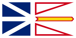
Newfoundland and Labrador's present provincial flag, designed by Newfoundland artist Christopher Pratt, was officially adopted by the legislature on May 28, 1980, and first flown on "Discovery Day" that year. Labrador has its own unofficial flag, created in 1973 by Mike Martin, former Member of the Legislative Assembly for Labrador South.
The blue is meant to represent the sea, the white represents snow and ice, the red represents the efforts and struggles of the people, and the gold represents the confidence of Newfoundlanders and Labradorians. The blue triangles are a tribute to the Union Flag, and represent the British heritage of the province. The two red triangles represent Labrador (the mainland portion of the province) and the island. The golden arrow is a union jack, placed on the flag as a reminder that Newfoundland was once owned by Britain. In Pratt's words, the union jack points towards a "brighter future".[80]

The "Pink, White and Green" is a flag of 19th-century origins that enjoyed popularity in portions of the island in the late 19th century. It was flown on some vessels into the 20th century. It was never adopted by the Newfoundland government.[64]
A 1976 article reported that the tricolour flag was created in 1843 by then Roman Catholic Bishop of Newfoundland, Michael Anthony Fleming.[81] The colours were intended to represent the symbolic union of Newfoundland's historically dominant ethnic/religious groups: English, Scots and Irish.[81] Though popular, there is no historical evidence to support this legend.
Recent scholarship suggests that the flag was first used in the 1870s or later by the Roman Catholic "Star of the Sea" fishermen's association. It resembled the unofficial flag of Ireland. The tri-colour flag remained relatively unknown outside of St. John's and the Avalon peninsula until the growth of the tourist industry since the late 20th century. It has been used as an emblem on items in gift shops in St. John's and other towns. Some tourists assume it is the Irish flag.
The "Pink, White and Green" has been adopted by some residents as a symbol of ties with Irish heritage and as a political statement. Many of the province's Protestants, who make up nearly 60% of the province's total population [82] may not identify with this heritage.
At the same time, many of the province's Catholics, approximately 37% of the total population (with at least 22% of the population claiming Irish ancestry),[83][84] think that the current provincial flag does not satisfactorily represent them.[85] But, a government-sponsored poll in 2005 revealed that 75% of Newfoundlanders rejected adoption of the Tricolour flag as the province's official flag.[86]
Pre-confederation and current provincial anthem
The pre-confederation and current provincial anthem is the "Ode to Newfoundland", written by British colonial governor Sir Charles Cavendish Boyle in 1902 during his administration of Newfoundland (1901 to 1904). It was adopted as the official Newfoundland anthem on May 20, 1904. In 1980, the province re-adopted the song as an official provincial anthem, making this the only province in Canada to officially adopt an anthem. "The Ode to Newfoundland" is still sung at public events in Newfoundland and Labrador.
Demographics
Newfoundland and Labrador has a population of 514,536,[2] more than half of whom live on the Avalon Peninsula of Newfoundland, site of the capital and historical early settlement.[87] Since 2006, the population of the province has started to increase for the first time since the early 1990s. In the 2006 census the population of the province decreased by 1.5% compared to 2001, and stood at 505,469.[88] But, by the 2011 census, the population had risen by 1.8%.[2]
|
Population of Newfoundland and Labrador since 1951
Source: Statistics Canada[89] |
Largest municipalities by population
|
Languages of the population
| ||||||||||||||||||||||||||||||||||||||||||||||||||||||||||||||||||||||||||||||||||||||||||||||||||||||||||||||||||||||||||||||||||||||||||||||||

The largest single religious denomination by number of adherents according to the 2011 National Household Survey was the Roman Catholic Church, at 35.8% of the province's population (181,590 members). The major Protestant denominations made up 57.3% of the population, with the largest groups being the Anglican Church of Canada at 25.1% of the total population (127,255 members), the United Church of Canada at 15.5% (78,380 members), and the Pentecostal churches at 6.5% (33,195 members), with other Protestant denominations in much smaller numbers. Non-Christians constituted only 6.8% of the population, with the majority of those respondents indicating "no religious affiliation" (6.2% of the total population).[90]
According to the 2001 Canadian census, the largest ethnic group in Newfoundland and Labrador is English (39.4%), followed by Irish (19.7%), Scots (6.0%), French (5.5%), and First Nations (3.2%).[91] While half of all respondents also identified their ethnicity as "Canadian," 38% report their ethnicity as "Newfoundlander" in a 2003 Statistics Canada Ethnic Diversity Survey.[92]
Economy
All currency is in Canadian dollars.
For many years, Newfoundland and Labrador had experienced a depressed economy. Following the collapse of the cod fishery during the early 1990s, the province suffered record unemployment rates and the population decreased by roughly 60,000.[89][93] Due to a major energy and resources boom, the provincial economy has had a major turnaround since the turn of the 21st century.[94] Unemployment rates decreased, the population stabilized and had moderate growth. The province has gained record surpluses, which has rid it of its status as a "have not" province.[95][96]

Economic growth, gross domestic product (GDP), exports and employment resumed in 2010, after suffering the impacts of the late-2000s recession. In 2010, total capital investment in the province grew to $6.2 billion, an increase of 23.0% compared to 2009. 2010 GDP reached $28.1 billion, compared to $25.0 billion in 2009.[97]
Service industries accounted for the largest share of GDP, especially financial services, health care and public administration. Other significant industries are mining, oil production and manufacturing. The total workforce in 2010 was 263,800 people.[98][99] Per capita GDP in 2008 was $61,763, higher than the national average and third only to Alberta and Saskatchewan out of Canadian provinces.[100]
Mines in Labrador, the iron ore mine at Wabush/Labrador City, and the nickel mine in Voisey's Bay produced a total of $3.3 billion worth of ore in 2010.[97] A mine at Duck Pond (30 km (18 mi) south of the now-closed mine at Buchans), started producing copper, zinc, silver and gold in 2007, and prospecting for new ore bodies continues.[101] Mining accounted for 3.5% of the provincial GDP in 2006.[99] The province produces 55% of Canada's total iron ore.[102] Quarries producing dimension stone such as slate and granite, account for less than $10 million worth of material per year.[103] Oil production from offshore oil platforms on the Hibernia, White Rose and Terra Nova oil fields on the Grand Banks was of 110,000,000 barrels (17,000,000 m3), which contributed to more than 15% of the province's GDP in 2006. Total production from the Hibernia field from 1997 to 2006 was 733,000,000 barrels (116,500,000 m3) with an estimated value of $36 billion. This will increase with the inclusion of the latest project, Hebron. Remaining reserves are estimated at almost 2 billion barrels (320×106 m3) as of December 31, 2006. Exploration for new reserves is ongoing.[99]

On June 16, 2009, provincial premier Danny Williams announced a tentative agreement to expand the Hibernia Oil Field. The government negotiated a 10-per-cent equity stake in the Hibernia South expansion, which will add an estimated $10 billion to Newfoundland and Labrador's treasury.[104]
The fishing industry remains an important part of the provincial economy, employing roughly 20,000 and contributing over $440 million to the GDP. The combined harvest of fish such as cod, haddock, halibut, herring and mackerel was 150,000 tonnes (165,000 tons) valued at about $130 million in 2006. Shellfish, such as crab, shrimp and clams, accounted for 195,000 tonnes (215,000 tons) with a value of $316 million in the same year. The value of products from the seal hunt was $55 million.[99] Aquaculture is a new industry for the province, which in 2006 produced over 10,000 tonnes of Atlantic salmon, mussels and steelhead trout worth over $50 million.[99]
Newsprint is produced by one paper mill in Corner Brook with a capacity of 420,000 tonnes (462,000 tons) per year. The value of newsprint exports varies greatly from year to year, depending on the global market price. Lumber is produced by numerous mills in Newfoundland.
Apart from seafood processing, paper manufacture and oil refining,[105] manufacturing in the province consists of smaller industries producing food,[106] brewing and other beverage production.
Agriculture in Newfoundland is limited to areas south of St. John's, Cormack, Wooddale, areas near Musgravetown and in the Codroy Valley. Potatoes, rutabagas, turnips, carrots and cabbage are grown for local consumption. Poultry and eggs are also produced. Wild blueberries, partridgeberries (lingonberries) and bakeapples (cloudberries) are harvested commercially and used in jams and wine making.[107] Dairy production is another huge part of the Newfoundland Agriculture Industry.
Tourism is also a significant contributor to the province's economy. In 2006 nearly 500,000 non-resident tourists visited Newfoundland and Labrador, spending an estimated $366 million.[99] Tourism is most popular throughout the months of June–September, the warmest months of the year with the longest hours of daylight.
Government and politics

Newfoundland and Labrador is governed by a parliamentary government within the construct of constitutional monarchy; the monarchy in Newfoundland and Labrador is the foundation of the executive, legislative, and judicial branches.[108] The sovereign is Queen Elizabeth II, who also serves as head of state of 15 other Commonwealth countries, each of Canada's nine other provinces and the Canadian federal realm; she resides in the United Kingdom. The Queen's representative in Newfoundland and Labrador is the Lieutenant Governor of Newfoundland and Labrador, presently Frank Fagan.[109]
The direct participation of the royal and viceroyal figures in any of these areas of governance is limited; in practice, their use of the executive powers is directed by the Executive Council, a committee of ministers of the Crown responsible to the unicameral, elected House of Assembly and chosen and headed by the Premier of Newfoundland and Labrador Dwight Ball the head of government.[110] To ensure the stability of government, the lieutenant governor will usually appoint as premier the person who is usually the current leader of the political party that can obtain the confidence of a plurality in the House of Assembly. The leader of the party with the second-most seats usually becomes the Leader of Her Majesty's Loyal Opposition and is part of an adversarial parliamentary system intended to keep the government in check.[111]
Each of the 40 Members of the House of Assembly (MHA) is elected by simple plurality in an electoral district. General elections must be called by the lieutenant governor on the second Tuesday in October four years after the previous election, or may be called, on the advice of the premier, should the government lose a confidence vote in the legislature.[112] Traditionally, politics in the province have been dominated by both the Liberal Party and the Progressive Conservative Party. However, in the 2011 provincial election the New Democratic Party, which had only ever attained minor success, had a major breakthrough and placed second in the popular vote behind the Progressive Conservatives.[113]
Culture
Art
Prior to 1950, the formal visual arts were a minor aspect of Newfoundland cultural life compared to the performing arts such as music or theatre. Until about 1900, most art was the work of visiting artists, which included members of the Group of Seven, Rockwell Kent, and Eliot O'Hara. Artists such as Newfoundland-born Maurice Cullen and Robert Pilot traveled to Europe to study art with prominent ateliers.[114]
%2C_oil_on_canvas._122.5_cm_x_153.25._The_Rooms_Provincial_Art_Gallery_Collection%2C_Gift_of_the_National_Art_Gallery_of_Canada.jpg)
By the turn of the century, amateur art was made by people living and working in the province. These artists included J.W. Hayward and his son Thomas B. Hayward; Agnes Marian Ayre; and Harold B. Goodridge who worked on a number of mural commissions, notably one for the lobby of the Confederation Building in St. John's.[115] Local art societies became prominent in the 1940s, particularly The Art Students Club, which opened in 1940.[116]
After Newfoundland and Labrador joined Canada in 1949, government grants fostered a supportive environment for visual artists, primarily painters. The visual arts of the province developed significantly in the second half of the century, with the return of young Newfoundland artists who had studied abroad. Among the first were Rae Perlin, who studied at the Art Students League in New York, and Reginald Shepherd and Helen Parsons Shepherd, who both graduated from the Ontario College of Art.[115] The Shepherds would establish the province's first art school, the Newfoundland Academy of Art, in a home in downtown St. John's.[117]
Newfoundland-born painter Christopher Pratt returned to the province in 1961 with his wife Mary Pratt to work at the newly established Memorial University Art Gallery as its first curator, later transitioning to painting full-time in Salmonier. Wesleyville's David Blackwood graduated from the Ontario College of Art in the early 1960s and has achieved acclaim with his images of Newfoundland culture and history, though he no longer resides in the province. Newfoundland-born artist Gerald Squires returned in 1969.[115]
The creation of The Memorial University Extension Services and St. Michael's Printshop in the 1960s and 1970s attracted a number of visual artist to the province to teach and create art. Similarly, the school in Hibbs Hole (now Hibb's Cove), established by painter George Noseworthy, brought professional artists such as Anne Meredith Barry to the province.[118] A notable artist during this period is Marlene Creates.[115]
From 1980 to present, opportunities for artists continued to develop, as art galleries such as the Art Gallery of Newfoundland and Labrador (which later became The Rooms Provincial Art Gallery), the Resource Centre for the Arts, and Eastern Edge were established. Fine arts education programs were established at post-secondary institutions such as Sir Wilfred Grenfell College in Corner Brook, the Western Community College (now College of the North Atlantic) in Stephenville, and the Anna Templeton Centre in St. John's.[119]
Newfoundland and Labrador's arts community is recognized nationally and internationally. The creation of Fogo Island Arts in 2008 on Fogo Island created a residency-based contemporary art program for artists, filmmakers, writers, musicians, curators, designers, and thinkers.[120] In 2013 and 2015, the province was represented at the Venice Biennale as Official Collateral Projects.[121] In 2015, Philippa Jones became the first Newfoundland and Labrador artist to be included in the National Gallery of Canada contemporary art biennial.[122] Other notable contemporary artists who have received national and international attention include Will Gill, Kym Greeley, Ned Pratt and Peter Wilkins.
As of 2011, a study recorded approximately 1,200 artists, representing 0.47% of the province's labour force.[123]
Music
Newfoundland and Labrador has a folk musical heritage based on the Irish, English and Scottish traditions that were brought to its shores centuries ago. Though similar in its Celtic influence to neighbouring Nova Scotia and Prince Edward Island, Newfoundland and Labrador are more Irish than Scottish, and have more elements imported from English and French music than those provinces. Much of the region's music focuses on the strong seafaring tradition in the area, and includes sea shanties and other sailing songs. Some modern traditional musicians include Great Big Sea, The Ennis Sisters, Shanneyganock, Sharecroppers, The Dardanelles, Ron Hynes, and The Navigators.
There is a Symphony Orchestra in St John's, which began in 1962 as a 20-piece string orchestra known as the St. John's Orchestra.[124] Principals from this form a string quartet which performs regularly. There is also a School of Music at Memorial University which schedules a variety of concerts, and has a chamber orchestra, jazz band, etc.[125] Two members of the faculty, Nancy Dahn on violin and Timothy Steeves on piano, form the internationally renowned Duo Concertante.[126] They are also responsible for establishing an annual music festival in August, the Tuckamore Festival,[127] Both the School of Music and Opera on the Avalon[128] produce operatic works.
Literature
See also Newfoundland in fiction
Prose fiction
The first novelist really to attempt local publication was Anastasia English (c.1862- 1959), Only a Fisherman’s Daughter [1899], Faithless: A Newfoundland Romance [1901], The Queen of Fairy Dell and Other Tales [1912.[129] However, Margaret Duley (1894 – 1968) was arguably Newfoundland's first novelist of either sex, to gain an international audience. Amongst her works are The Eyes of the Gull (1936), Cold Pastoral (1939} and Highway to Valour (1941).[130] Harold Horwood (1923 – 2006) Tomorrow Will Be Sunday (1966), White Eskimo (1972) Percy Janes (1922 - 1999), House of Hate (1970). are important later Newfoundland novelists.[131]
Amongst subsequent novelists amongst the most important are Michael Crummey, Wayne Johnston, Lisa Moore, and Kenneth J. Harvey.

Michael Crummey (born 1965) Crummey's debut novel, River Thieves (2001) became a Canadian bestseller, and won the Thomas Head Raddall Award, the Winterset Award for Excellence in Newfoundland Writing, and the Atlantic Independent Booksellers' Choice Award. It was also shortlisted for the Giller Prize, the Commonwealth Writers' Prize, the Books in Canada First Novel Award, and was long-listed for the IMPAC Award.[132] His second novel, The Wreckage (2005), was longlisted for the 2007 IMPAC Award. His third novel Galore (2009) shortlisted for the 2011 IMPAC Award.[132]
Wayne Johnston's (born 1958) fiction deals primarily with the province of Newfoundland and Labrador, often in a historical setting.[133] His first novel, The Story of Bobby O'Malley won him early critical notice, and the W.H. Smith/Books in Canada First Novel Award in 1985. His second novel, The Time of Their Lives, won the Air Canada/Canadian Authors Association Award for Most Promising Young Canadian Writer in 1988.[134] His novel The Divine Ryans won the 1991 Thomas Head Raddall Award,[135] and was subsequently adapted to the screen. Johnston's breakthrough novel, 1998's The Colony of Unrequited Dreams - shortlisted for both the Giller Prize and the Governor General's Award for fiction - was acclaimed for its historical portrayal of legendary Newfoundland politician Joey Smallwood. It was featured on the cover of the New York Times Book Review when it was released in the United States, and was an international best seller. The Colony of Unrequited Dreams won or was nominated for sixteen national and international awards.[136] In 2002, Johnston published The Navigator of New York, which was shortlisted for both the Giller Prize and the Governor General's Award for fiction. Johnston was awarded the Writers' Trust Engel/Findley Award in recognition of his contribution to Canadian Literature in 2011. Several of Johnston's books have been published in the United States, the United Kingdom, the Netherlands, Germany and China.[137]
Kenneth J. Harvey (born 1962) is an award-winning, international, bestselling novelist, whose books are published throughout the world. Amongst these are The Town That Forgot How to Breathe (2003), which won the 2004 Thomas Head Raddall Award and Italy's Libro del Mare), Inside (2006), long listed for the Giller Prize), winner of the Rogers Writers' Trust Fiction Prize, and the Winterset Award, and Blackstrap Hawco (2008), which was long listed for the Giller Prize), and shortlisted for the Commonwealth Writers Prize.
Lisa Moore (born 1964).first two books, Degrees of Nakedness (1995) and Open (2002), are short story collections. Open was a commercial and critical breakthrough, earning a nomination for the Giller Prize. Her first novel, Alligator (2005), was also nominated for the Giller Prize. It won the 2006 Commonwealth Writers' Prize Best Book Award, Caribbean and Canada Region, and was long listed for the 2007 IMPAC Award.[138] Moore often incorporates her Newfoundland heritage in her work; Alligator, for example, is set in St. John's. February tells the story of Helen O'Mara, who lost her husband Cal when the oil rig, Ocean Ranger, sank off the coast of Newfoundland during a Valentine's Day storm in 1982. Moore was one of 13 novelists on the long list for the 2010 Man Booker Prize for her novel February,[139]
Poetry
The earliest works of poetry in British North America, mainly written by visitors and targeted at a European audience, described the new territories in optimistic terms. One of the first works was Robert Hayman's Quodlibets, composed in Newfoundland and published in 1628.

After World War II, Newfoundland poet E. J. Pratt (1882 – 1964) described the struggle to make a living from the sea in poems about maritime life and the history of Canada; In 1923 Pratt's first commercial poetry collection, Newfoundland Verse, was released.[140] It is frequently archaic in diction, and reflects a pietistic and late-Romantic lyrical sensibility. The collection has humorous and sympathetic portraits of Newfoundland characters, and creates an elegiac mood in poems concerning sea tragedies or Great War losses.[141] With illustrations by Group of Seven member Frederick Varley, Newfoundland Verse proved to be Pratt's "breakthrough collection." He would publish 18 more books of poetry in his lifetime.[142] "Recognition came with the narrative poems The Witches’ Brew (1925), Titans (1926), and The Roosevelt and the Antinoe (1930), and though he published a substantial body of lyric verse, it is as a narrative poet that Pratt is remembered." [143] Pratt's poetry "frequently reflects his Newfoundland background, though specific references to it appear in relatively few poems, mostly in Newfoundland Verse," says The Canadian Encyclopedia. "But the sea and maritime life are central to many of his poems, for example, "The Cachalot" (1926), describing duels between a whale and its foes, a giant squid and a whaling ship and crew.[144]
Amongst other, more recent poets are Tom Dawe, Al Pittman, Mary Dalton, Agnes Walsh, Patrick Warner[145] and John Steffler. Canadian poet Don McKay has resided in St John's in recent years.[146]
Playwrights
"1967 marked the opening of the St. John's Arts and Culture Centre and the first all-Canadian Dominion Drama Festival. Playwrights across Canada began writing, and this explosion was also felt in Newfoundland and Labrador. Subregional festivals saw Newfoundland plays compete - Wreakers by Cassie Brown, Tomorrow Will Be Sunday by Tom Cahill, and Holdin' Ground by Ted Russell. Cahill's play went on to receive top honours and a performance at Expo 67 in Montreal. Joining Brown and Cahill in the seventies were Michael Cook and Al Pittman, both prolific writers".[147]
Languages spoken in the Province
Newfoundland English is a name for several accents and dialects of English found in the province of Newfoundland and Labrador. Most of these differ substantially from the English commonly spoken elsewhere in neighbouring Canada and the North Atlantic. Many Newfoundland dialects are similar to the West Country dialects of the West Country in England, particularly the city of Bristol and counties Cornwall, Devon, Dorset, Hampshire and Somerset, while others resemble dialects of Ireland's southeast, particularly Waterford, Wexford, Kilkenny and Cork. Still others blend elements of both, and there is also a Scottish [148] influence on the dialects. While the Scots came in smaller numbers than the English and Irish, they had a large influence on Newfoundland society.[83][149][150]
Newfoundland was also the only place outside Europe to have its own distinct name in Irish: Talamh an Éisc, which means 'land of the fish'. The Irish language is now extinct in Newfoundland. Scots Gaelic was also once spoken in the southwest of Newfoundland, following the settlement there, from the middle of the 19th century, of small numbers of Gaelic-speaking Scots from Cape Breton, Nova Scotia. Some 150 years later, the language has not entirely disappeared, although it has no fluent speakers.[151]
A vestigial community of French speakers exists on Newfoundland's Port au Port Peninsula; a remnant of the "French Shore" along the island's west coast.[152]
Several aboriginal languages are spoken in the Province, representing the Algonquian (Beothuk, Mi'kmaq and Innu) and Eskimo-Aleut (Inuktitut) language families.[152]
See Dictionary of Newfoundland English, 2d ed
Sports
Newfoundland and Labrador has a somewhat different sports culture from the rest of Canada, owing in part to its long history separate from the rest of Canada and under British rule. Ice hockey, however, remains popular; the St. John's IceCaps play professionally at the Mile One Centre in St. John's, and the Newfoundland Senior Hockey League has teams around the island. Since the departure of the St. John's Fog Devils in 2008, Newfoundland and Labrador is the only province in Canada to not have a team in the Canadian Hockey League (should one ever join it would be placed in the QMJHL, which hosted the Fog Devils and has jurisdiction over Atlantic Canada).
Association football (soccer) and rugby union are both more popular in Newfoundland and Labrador than the rest of Canada in general. Soccer is hosted at King George V Park, a 6,000-seat stadium built as Newfoundland's national stadium during the time as an independent dominion. Swilers Rugby Park is home of the Swilers RFC rugby union club, as well as the The Rock, one of the four regional teams in the Canadian Rugby Championship. Other sports facilities in Newfoundland and Labrador include Pepsi Centre, an indoor arena in Corner Brook; Shamrock Field, Canada's national Gaelic Games venue in St. John's; and St. Patrick's Park, a baseball park in St. John's.
Gridiron football, be it either American or Canadian, is almost nonexistent; it is the only Canadian province other than Prince Edward Island to have never hosted a Canadian Football League or Canadian Interuniversity Sport game, and it was not until 2013 that the province saw its first amateur teams form.
Transportation

Within the province, the Newfoundland and Labrador Department of Transportation and Works operates or sponsors 15 automobile, passenger and freight ferry routes which connect various communities along the province's significant coastline.[153]
A regular passenger and car ferry service, lasting about 90 minutes, crosses the Strait of Belle Isle, connecting the province's island of Newfoundland with the region of Labrador on the mainland. The ferry MV Apollo travels from St. Barbe, Newfoundland on the Great Northern Peninsula to the port town of Blanc-Sablon, Quebec, located on the provincial border and beside the town of L'Anse-au-Clair, Labrador.[154] The MV Sir Robert Bond once provided seasonal ferry service between Lewisporte on the island and the towns of Cartwright and Happy Valley-Goose Bay in Labrador, but has not run since the completion of the Trans Labrador highway in 2010, allowing access from Blanc-Sablon, Quebec to major parts of Labrador.[155] Several smaller ferries connect numerous other coastal towns and offshore island communities around the island of Newfoundland and up the Labrador coast as far north as Nain.[156]
Inter-provincial ferry services are provided by Marine Atlantic, a federal Crown corporation which operates auto-passenger ferries from North Sydney, Nova Scotia to the towns of Port aux Basques and Argentia on the southern coast of Newfoundland island.[157]
The St. John's International Airport YYT and the Gander International Airport YQX are the only airports in the province that are part of the National Airports System.[158] The St. John's International Airport handles nearly 1,200,000 passengers a year making it the busiest airport in the province and the eleventh busiest airport in Canada.[159] The airport is currently undergoing a major expansion of the terminal building which is scheduled to be complete in 2021.[160] The Deer Lake Airport YDF handles over 300,000 passengers a year.[161]
Provincial symbols
| Provincial symbols | |
| Official flower | Pitcher plant |
| Official tree | Black spruce |
| Official bird | Atlantic puffin |
| Official horse | Newfoundland pony |
| Official animal | Caribou |
| Official game bird | Ptarmigan |
| Official mineral | Labradorite |
| Official dogs | Newfoundland Dog and Labrador Retriever |
| Provincial anthem | "Ode to Newfoundland" |
| Provincial holiday | June 24, Discovery Day |
| Patron saint | John the Baptist |
| Official tartan |  |
| Great seal |  |
| Coat of arms | 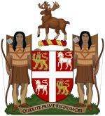 |
| Escutcheon |  |
| Provincial wordmark | |
See also
- Index of Newfoundland and Labrador-related articles
- Acadiensis, scholarly history journal covering Atlantic Canada
- List of mammals of Newfoundland Island
- Nunatsiavut
- List of communities in Newfoundland and Labrador
- Higher education in Newfoundland and Labrador
References
- ↑ http://www.innu-aimun.ca/dictionary/Words
- 1 2 3 "Population and dwelling counts, for Canada, provinces and territories, 2011 and 2006 censuses". Statistics Canada. January 30, 2013. Retrieved November 3, 2013.
- ↑ "Population by year of Canada of Canada and territories". Statistics Canada. September 26, 2014. Retrieved March 20, 2016.
- ↑ Although the term "Newfie" is sometimes used in casual speech, some Newfoundlanders consider it a pejorative.
- ↑ "Gross domestic product, expenditure-based, by province and territory (2011)". Statistics Canada. November 19, 2013. Retrieved September 26, 2013.
- ↑ "Estimates of population, Canada, provinces and territories". Statistics Canada. Retrieved September 28, 2013.
- ↑ Population by mother tongue and age groups, 2006 counts, for Canada, provinces and territories - 20% sample data. 2.statcan.ca (2009-03-24). Retrieved on 2013-07-12.
- ↑ "Newfoundland's name change now official". Canadian Broadcasting Corporation. December 6, 2001. Retrieved March 10, 2012.
- ↑ Hamilton, William B. (1978): The Macmillan book of Canadian place names, Macmillan of Canada, Toronto, p. 105.
- ↑ "Geography and Climate". Government of Newfoundland and Labrador. Retrieved January 10, 2011.
- 1 2 Bell, Trevor; Liverman, David. "Landscape (of Newfoundland and Labrador)". Memorial University of Newfoundland. Retrieved June 16, 2008.
- 1 2 "Atlas of Canada: Sea islands". Natural Resources Canada (Government of Canada). Retrieved June 16, 2008.
- 1 2 "About Newfoundland and Labrador: Land Area". Government of Newfoundland and Labrador. Retrieved June 16, 2008.
- ↑ Bélanger, Claude. "Newfoundland Geography". Marianopolis College. Retrieved June 16, 2008.
- ↑ "Location and Climate". Government of Newfoundland and Labrador. Archived from the original on April 15, 2008. Retrieved June 16, 2008.
- ↑ "Atlas of Canada: Land and Freshwater Areas". Natural Resources Canada (Government of Canada). Retrieved June 16, 2008.
- ↑ "Report on the State of Conservation of Gros Morne National Park". Parks Canada. Retrieved June 16, 2008.
- ↑ "Newfoundland and Labrador Heritage Web Site: Climate". Memorial University of Newfoundland. Retrieved June 16, 2008.
- 1 2 "Weather and Your Home: The Climate of Newfoundland". The Weather Network. Retrieved January 10, 2011.
- ↑ "Climate Characteristics". Memorial University of Newfoundland. Retrieved June 17, 2008.
- ↑ "Station Results - 1981-2010 Climate Normals and Averages". Environment Canada. Retrieved May 9, 2016.
- 1 2 3 "The Climate of Newfoundland". Environment Canada. Archived from the original on May 19, 2008. Retrieved June 17, 2008.
- ↑ "National Climate Data and Information Archive". Environment Canada. Retrieved September 2, 2010.
- ↑ Tuck, James A. "Museum Notes – The Maritime Archaic Tradition". "The Rooms" Provincial museum. Retrieved June 17, 2008.
- 1 2 3 Bogucki, Peter I (1999). The Origins of Human Society. Blackwell. p. 139. ISBN 1-55786-349-0. Retrieved May 2, 2011.
- ↑ "Museum Notes-The Maritime Archaic Tradition". By James A. Tuck-The Rooms Provincial Art Gallery. Retrieved October 5, 2009.
- ↑ Tuck, J. A. (1976). "Ancient peoples of Port au Choix". The excavation of an Archaic Indian Cemetery in Newfoundland. Newfoundland Social and Economic Studies 17. St. John's: Institute of Social and Economic Research. ISBN 0-919666-12-4.
- 1 2 3 Ralph T. Pastore, "Aboriginal Peoples: Palaeo-Eskimo Peoples", Newfoundland and Labrador Heritage: Newfoundland and Labrador Studies Site 2205, 1998, Memorial University of Newfoundland
- 1 2 Wonders, William C (2003). Canada's Changing North. McGill-Queen's University Press. pp. 88–89. ISBN 0-7735-2590-4.
- 1 2 3 Marshall, Ingeborg (1998). A History and Ethnography of the Beothuk. McGill-Queen's University Press. p. 13. ISBN 0-7735-1774-X.
- ↑ Pritzker, Barry (2000). A Native American encyclopedia: history, culture, and peoples. Oxford University Press. p. 535. ISBN 0-19-513877-5.
- ↑ =Smith, Eric Alden (1991). Inujjuamiut foraging strategies : evolutionary ecology of an arctic hunting economy. A. de Gruyter. p. 101. ISBN 0-202-01181-X.
- 1 2 Luebering, J E (2011). Native American History. Educational Britannica Educational. p. 37. ISBN 978-1-61530-265-9.
- ↑ Magocsi, Paul R (2002). Aboriginal peoples of Canada: a short introduction. University of Toronto Press. p. 102. ISBN 0-8020-3630-9.
- ↑ Hornborg, Anne-Christine (2007). Mi'kmaq landscapes: from animism to sacred ecology. Burlington, VT : Ashgate. p. 4. ISBN 978-0-7546-6371-3.
- ↑ William, Baillie Hamilton (1996). Place names of Atlantic Canada. University of Toronto Press. p. 3. ISBN 0-8020-0471-7.
- ↑ Wicken, William (2002). Mi'kmaq Treaties on Trial: History, Land and Donald Marshall Junior. University of Toronto Press. p. 53. ISBN 0-8020-0718-X.
- ↑ Holly, Jr., Donald H. (2000). "The Beothuk on the Eve of Their Extinction". Arctic Anthropology. 37 (1): 79–95.
- ↑ National Geographic 26 November, 2010
- ↑ Pálsson, Hermann (1965). The Vinland sagas: the Norse discovery of America. Penguin Classics. p. 28. ISBN 0-14-044154-9. Retrieved April 15, 2010.
- ↑ J. Sephton, (English, translation) (1880). "The Saga of Erik the Red". Icelandic Saga Database. Retrieved August 11, 2010.
- ↑ "Vikings: The North Atlantic Saga". National Museum of Natural History, Arctic Studies Center- (Smithsonian Institution). 2008. Retrieved August 11, 2010.
- ↑ Diamond, Jared M (2006). Collapse: How Societies Choose to Fail Or Succeed. Penguin Books. p. 207. ISBN 0-14-303655-6. Retrieved April 16, 2010.
- ↑ Haugen, Einar (Professor emeritus of Scandinavian Studies, Harvard University). "Was Vinland in Newfoundland?". (Originally published in "Proceedings of the Eighth Viking Congress, Arhus. August 24–31, 1977". Edited by Hans Bekker-Nielsen, Peter Foote, Olaf Olsen. Odense University Press. 1981. Archived from the original on May 15, 2001. Retrieved June 21, 2010.
- ↑ "L'Anse aux Meadows National Historic Site". UNESCO World Heritage Centre (United Nations). 2010. Retrieved April 15, 2010.
- ↑ "L'Anse aux Meadows National Historic Site of Canada". Parks Canada. 2007. Retrieved April 15, 2010.
- ↑ Bailey W. Diffie & George D. Winius (1977). Foundations of the Portuguese empire. University of Minnesota Press. p. 464. ISBN 0-8166-0782-6. Retrieved August 13, 2010.
- ↑ "John Cabot's voyage of 1498". Memorial University of Newfoundland (Newfoundland and Labrador Heritage). 2000. Retrieved April 12, 2010.
- ↑ Vigneras, L.-A. (1979) [1966]. "Corte-Real, Miguel". In Brown, George Williams. Dictionary of Canadian Biography. I (1000–1700) (online ed.). University of Toronto Press.
- ↑ Diffie, Bailey W; Winius, George D (1977). Foundations of the Portuguese empire. University of Minnesota Press. pp. 464–465. ISBN 0-8166-0782-6. Retrieved August 13, 2010.
- ↑ "PORTUGUESE BULLS, FIRST IN NORTH AMERICA". Dr. Manuel Luciano da Silva. 2000. Retrieved April 12, 2010.
- ↑ Freeman-Grenville (1975). Chronology of world history: a calendar of principal events from 3000 BC to.. Rowman & Littlefield. p. 387. ISBN 0-87471-765-5.
- ↑ Brian Cuthbertson, "John Cabot and His Historians: Five Hundred Years of Controversy." Journal of the Royal Nova Scotia Historical Society 1998 1: 16–35. ISSN 1486-5920.
- ↑ See Samuel Eliot Morison, The European Discovery of America: The Northern Voyages (1971)
- ↑ http://canadashistory.ca/Community/Community-Features/Articles/Basque-Will
- ↑ http://www.placentiahistory.ca/images/pdfs/Basque_will_translation_PDF.pdf
- ↑ Sugden, John (1990). Sir Francis Drake. Barrie & Jenkins. p. 118. ISBN 0-7126-2038-9.
- ↑ Grant C. Head, Eighteenth Century Newfoundland: A Geographer's Perspective (1976)
- ↑ Fraser, Allan M. (1979) [1966]. "Calvert, Sir George". In Brown, George Williams. Dictionary of Canadian Biography. I (1000–1700) (online ed.). University of Toronto Press.
- ↑ Compare: Moir, John S. (1979) [1966]. "Kirke, Sir David". In Brown, George Williams. Dictionary of Canadian Biography. I (1000–1700) (online ed.). University of Toronto Press.
- ↑ Gordon W. Handcock, "So Longe as There Comes Noe Women": Origins of English Settlement in Newfoundland (1989)
- ↑ "History of Placentia". Memorial University of Newfoundland. Retrieved February 26, 2010.
- ↑ Webb, Jeff. "Representative Government, 1832–1855". Retrieved October 17, 2008.
- 1 2 3 "THE PROVINCES Chap XIX: Newfoundland". Retrieved June 22, 2010.
- 1 2 3 "Newfoundland & Labrador and Canadian Federalism – History of Newfoundland & Labrador". Mapleleafweb. Retrieved February 5, 2011.
- ↑ Cadigan, Sean Thomas (2009). Newfoundland and Labrador: a history. University of Toronto Press. ISBN 978-0-8020-4465-5.
- 1 2 "Collapse of Responsible Government, 1929–1934". Heritage Newfoundland and Labrador. Retrieved February 5, 2011.
- 1 2 3 4 5 6 Malone, Greg (2012). Don't Tell the Newfoundlanders: The True Story of Newfoundland's Confederation with Canada. Toronto: Alfred A Knopf Canada. ISBN 978-0-307-40133-5.:145
- ↑ Peter Neary, Newfoundland in the North Atlantic World, 1929-1949 (Montreal and Kingston: McGill-Queen's University Press, 1988), especially chapter 2
- ↑ "The Commission of Government, 1934–1949". Heritage Newfoundland and Labrador. Retrieved February 6, 2011.
- ↑ Gene Long, Suspended State: Newfoundland Before Canada (1999)
- 1 2 "The Newfoundland National Convention". Heritage.nf.ca. Retrieved December 3, 2010.
- ↑ Joseph Roberts Smallwood, I chose Canada: The Memoirs of the Honourable Joseph R. "Joey" Smallwood (1973) p. 256
- ↑ Richard Gwyn, Smallwood: The Unlikely Revolutionary (1972)
- ↑ David MacKenzie, Inside the Atlantic Triangle: Canada and the Entrance of Newfoundland into Confederation, 1939-49 (Toronto: University of Toronto Press, 1986), 192
- ↑ Michael J. Trinklein (2 May 2010). "Altered states: The strange history of efforts to redraw the New England map". Boston Globe.
- ↑ "The 1948 Referendums", Library and Archives Canada
- 1 2 "Newfoundland Joins Canada) and Newfoundland and Confederation (1949)". .marianopolis.edu. Retrieved December 3, 2010.
- ↑ Jeff Webb, "Confederation, Conspiracy and Choice: A Discussion," Newfoundland Studies 14, 2 (1998): 170-87.
- ↑ "The Newfoundland Flag". Retrieved June 25, 2010.
- 1 2 The Monitor, July 1976, Roman Catholic Archdiocese of Newfoundland
- ↑ "Statistics Canada: Population by religion, by province and territory (2001 Census)". Retrieved June 22, 2010.
- 1 2 "2006 Statistics Canada National Census: Newfoundland and Labrador". Statistics Canada. July 28, 2009.
- ↑ "Religions in Canada: Newfoundland and Labrador". Retrieved June 22, 2010.
- ↑ Carolyn Lambert, "Emblem of our Country", Newfoundland and Labrador Studies, Volume 23, Number 1, 2008.
- ↑ Mark Quinn, "Push for old Newfoundland flag fails to cause ripple, poll finds", Globe and Mail, October 29, 2005, A16
- ↑ "Annual Demographic Estimates:Subprovincial Areas" (PDF). Statistics Canada. Retrieved January 10, 2011.
- ↑ "Population and dwelling counts (2006 Census)". Statistics Canada. Retrieved January 10, 2011.
- 1 2 "Population, urban and rural, by province and territory (Newfoundland and Labrador)". Statistics Canada. Retrieved August 22, 2011.
- ↑ "NHS Profile, Newfoundland and Labrador, 2011". Statistics Canada. Retrieved November 12, 2014.
- ↑ "Population by selected ethnic origins, by province and territory (2006 Census)". 0.statcan.ca. July 28, 2009. Archived from the original on June 21, 2008. Retrieved July 26, 2010.
- ↑ The Daily, Monday, September 29, 2003. Ethnic Diversity Survey
- ↑ "Newfoundland and Labrador Fisheries". Heritage Newfoundland and Labrador. Retrieved December 21, 2011.
- ↑ McCarthy, Shawn (December 17, 2011). "Labour shortage looms in Newfoundland and Labrador". The Globe and Mail. Retrieved December 21, 2011.
- ↑ "The Economic Review 2011" (PDF). Government of Newfoundland and Labrador. 2011. Retrieved December 21, 2011.
- ↑ "Have-not is no more: N.L. off equalization". Canadian Broadcasting Corporation. November 3, 2008. Retrieved February 5, 2011.
- 1 2 "Economic Review 2010" (PDF). Government of Newfoundland and Labrador. Retrieved February 5, 2011.
- ↑ Stats Canada – Labour force characteristics by province, September 2010
- 1 2 3 4 5 6 "Economic Research and Analysis 2007". Economics and Statistics Branch, Department of Finance, Government of Newfoundland and Labrador, Office of the Queens Printer. Archived from the original on June 24, 2007. Retrieved June 17, 2008.
- ↑ Statistics Canada (November 11, 2009). "Gross domestic product, expenditure-based, by province and territory". Retrieved May 9, 2011.
- ↑ "Buchans mine". Filing Services Canada Inc. Retrieved June 17, 2006.
- ↑ Bell, Trevor; Liverman, David. "Mineral Resources". Memorial University of Newfoundland. Retrieved June 17, 2008.
- ↑ "Geological survey: Dimension stone in Newfoundland and Labrador". Natural Resources, Government of Newfoundland and Labrador. Retrieved June 17, 2008.
- ↑ "CBC News – Nfld. & Labrador – $10B Hibernia South deal reached: Williams". Cbc.ca. June 16, 2009. Retrieved July 26, 2010.
- ↑ "Project Review". Newfoundland and Labrador Refining Corporation. Retrieved June 17, 2008.
- ↑ "Purity Factories (Newfoundland food)". Retrieved October 26, 2007.
- ↑ "Rodriques Winery". Retrieved October 26, 2007.
- ↑ Department of Canadian Heritage (February 2009). "Canadian Heritage Portfolio" (PDF) (2nd ed.). Queen's Printer for Canada: 3–4. ISBN 978-1-100-11529-0. Retrieved May 23, 2011.
- ↑ Office of the Lieutenant Governor of Newfoundland and Labrador. "Lieutenant Governor of Newfoundland and Labrador > Role and Duties". Queen's Printer for Newfoundland and Labrador. Retrieved September 13, 2012.
- ↑ "Dunderdale becomes 1st woman to lead N.L.". CBC. December 3, 2010. Retrieved January 19, 2011.
- ↑ Library of Parliament. "The Opposition in a Parliamentary System". Queen's Printer for Canada. Retrieved May 23, 2011.
- ↑ "An Act To Amend The House of Assembly Act and the Elections Act, 1991". Queen's Printer for Newfoundland and Labrador. December 13, 2004. Retrieved January 20, 2011.
- ↑ Moore, Oliver (October 12, 2011). "'Orange wave' credited with slimming Tory majority in Newfoundland". The Globe and Mail. Retrieved December 21, 2011.
- ↑ Mireille Eagan."Before Category," PAGES, vol. 1 no. 1, (The Rooms), 2013. p. 37
- 1 2 3 4 http://www.heritage.nf.ca/articles/arts/visual-arts.php
- ↑ "Without a Suitable Gallery, Club Tries to Encourage Nfld. Art," The Daily News, (June 23, 1950).
- ↑ http://www.heritage.nf.ca/articles/arts/reginald-shepherd.php
- ↑ Mireille Eagan."Before Category," PAGES, vol. 1 no. 1, (The Rooms), 2013. p. 43
- ↑ Mireille Eagan."Before Category," PAGES, vol. 1 no. 1, (The Rooms), 2013. p. 43-44
- ↑ http://fogoislandarts.ca/about/fogo-island-arts/
- ↑ http://canadianart.ca/news/newfoundland-officially-accepted-venice-biennale/
- ↑ http://www.ngcmagazine.ca/videos/shine-a-light-canadian-biennial-2014-philippa-jones
- ↑ http://www.hillstrategies.com/content/artists-and-cultural-workers-canada%E2%80%99s-provinces-and-territories
- ↑ Newfoundland Symphony Orchestra
- ↑ School of Music Memorial University
- ↑ Duo Concertante
- ↑ Tuckamore Festival .
- ↑ Opera on the Avalon
- ↑ http://www.hbic.library.utoronto.ca/fconfnfld_en.htm
- ↑ Patrick O'Flaherty, The Rock Observed: Studies in the Literature of Newfoundland. (University of Toronto Press, 1979).
- ↑ Patrick O'Flaherty, The Rock Observed.
- 1 2 Canadian Encyclopaedia
- ↑ Johnston, Wayne: The Canadian Encyclopedia
- ↑ Author Biography
- ↑ Book Description - The Divine Ryans
- ↑ Canadian Encyclopaedia
- ↑ Canadian Encyclopaedia, .
- ↑ Canadian Encyclopaedia
- ↑ (27 July 2010). "[http://www.cbc.ca/arts/books/story/2010/07/27/booker-long-list.html Lisa Moore nominated for Man Booker Prize", CBC News. Retrieved 29 July 2010.
- ↑ "E. J. Pratt:Biography," Canadian Poetry Online, University of Toronto Libraries. Web, Mar. 17, 2011.
- ↑ Susan Gingell, "E. J. Pratt Biography - (1882–1964)", Encyclopedia of Literature, 8534. JRank.org, Web, Mar. 26, 2011.
- ↑ Brian Trehearne ed., "E. J. Pratt 1882-1964," Canadian Poetry 1920 to 1960 (Toronto: McLelland & Stewart, 2010), 21. Google Books, Web, Mar. 20, 2011.
- ↑ Nicola Vulpe, "Pratt, E.J. 1882–1964," Reader’s Guide to Literature in English. BookRags.com, Web, Mar. 26, 2011.
- ↑ David G. Pitt, "Pratt, Edwin John," Canadian Encyclopedia (Edmonton: Hurtig, 1988), 1736.
- ↑ Patrick Warner
- ↑ Brick Books
- ↑ Heritage Newfoundland and Labrador: Playwrights
- ↑ http://www.heritage.nf.ca/society/scottish.html
- ↑ http://www.heritage.nf.ca/society/west_country.html
- ↑ Newfoundland Historical Society, A Short History of Newfoundland and Labrador, St. John's, NL, Boulder Publications, 2008.
- ↑ Heritage Newfoundland and Labrador
- 1 2 Heritage Newfoundland and Labrador
- ↑ "Summary of Services Available". Department of Transportation and Works. Retrieved February 20, 2013.
- ↑ "Blanc Sablon (Labrador Straits Area) – St. Barbe". Department of Transportation and works. Retrieved July 30, 2012.
- ↑ "Minister Announces Changes to Labrador Marine Service". Department of Transportation and works. Retrieved July 30, 2012.
- ↑ "Routes, Schedules and Rates". Department of Transportation and works. Retrieved July 30, 2012.
- ↑ "Marine Atlantic". Marine-atlantic.ca. Retrieved July 26, 2010.
- ↑ "National Airports Policy – Airports in the national airports category". Transportation Canada. Retrieved August 29, 2011.
- ↑ "Passengers enplaned and deplaned on selected services – Top 50 airports". Statistics Canada. Retrieved August 29, 2011.
- ↑ "Airport Authority Unveils its 10-year Vision for Airport Improvements". St. John's International Airport Authority. Retrieved July 30, 2012.
- ↑ "Airport Ends Year With Modest Growth" (PDF). Retrieved August 8, 2011.
Further reading
- Cadigan, Sean Thomas (2009). Newfoundland and Labrador: a history. University of Toronto Press. ISBN 978-0-8020-4465-5.
- Hiller, James; Neary, Peter (1994). Twentieth-century Newfoundland: explorations. Breakwater,. ISBN 1-55081-072-3.
- Clarke, Sandra (2010). Newfoundland English. Edinburgh University Press. ISBN 978-0-7486-2616-8.
- Wilson, Donald; Ryan, Stanley (1990). Legends of Newfoundland & Labrador. Jesperson. ISBN 0-921692-40-4.
- Atlas of Newfoundland and Labrador by Department of Geography Memorial University of Newfoundland, Breakwater Books Ltd; ISBN 1-55081-000-6; (1991)
- Bavington, Dean L.Y. Managed Annihilation: An Unnatural History of the Newfoundland Cod Collapse (University of British Columbia Press; 2010) 224 pages. Links the collapse of Newfoundland and Labrador cod fishing to state management of the resource.
- Cadigan, Sean T. Newfoundland and Labrador: A History U. of Toronto Press, 2009. Standard scholarly history
- Casey, G.J. Casey and Elizabeth Miller, eds., Tempered Days: A Century of Newfoundland Fiction St. John's: Killick Press, 1996.
- Earle, Karl Mcneil. "Cousins of a Kind: The Newfoundland and Labrador Relationship with the United States" American Review of Canadian Studies Vol: 28. Issue: 4. 1998. pp: 387–411.
- Fay, C. R. Life and Labour in Newfoundland University of Toronto Press, 1956
- Department of Finance, Economic Research and Analysis. "The Economic Review 2010" Dec. 2010
- Jackson, Lawrence. Newfoundland & Labrador Fitzhenry & Whiteside Ltd; ISBN 1-55041-261-2; (1999)
- Gene Long, Suspended State: Newfoundland Before Canada Breakwater Books Ltd; ISBN 1-55081-144-4; (April 1, 1999)
- R. A. MacKay; Newfoundland; Economic, Diplomatic, and Strategic Studies Oxford University Press, 1946
- Patrick O'Flaherty, The Rock Observed: Studies in the Literature of Newfoundland University of Toronto Press, 1979
- Joseph Smallwood ed. The Encyclopedia of Newfoundland and Labrador St. John's: Newfoundland Book Publishers, 1981–, 2 vol.
- This Marvelous Terrible Place: Images of Newfoundland and Labrador by Momatiuk et al., Firefly Books; ISBN 1-55209-225-9; (September 1998)
- True Newfoundlanders: Early Homes and Families of Newfoundland and Labrador by Margaret McBurney et al., Boston Mills Pr; ISBN 1-55046-199-0; (June 1997)
- Biogeography and Ecology of the Island of Newfoundland: Monographiae Biologicae by G. Robin South (Editor) Dr W Junk Pub Co; ISBN 90-6193-101-0; (April 1983)
External links
| Wikimedia Commons has media related to Newfoundland and Labrador. |
| Wikivoyage has a travel guide for Newfoundland and Labrador. |
- Government of Newfoundland and Labrador
- Centre for Newfoundland Studies
- Newfoundland and Labrador at DMOZ
- Songs of Newfoundland and Labrador
- Fisheries Heritage website
- Official Tourism Website
- Newfoundland and Labrador's Web 2.0 Nature Atlas by Memorial University and Dept. of Wildlife
- Newfoundland and Labrador's Provincial Register of Historic Places

| Government and politics |  | |
|---|---|---|
| Geography |
| |
| Culture | ||
| Economy and Transportation |
| |
| History |
| |
| ||
| Census divisions | |
|---|---|
| Cities | |
| Other communities |
|
| |
| Provinces | |
|---|---|
| Territories | |
| Historical | |
| Related | |
| |
| History |
| ||||||
|---|---|---|---|---|---|---|---|
| Provinces and territories |
| ||||||
| Government | |||||||
| Politics | |||||||
| Geography |
| ||||||
| Economy | |||||||
| Society | |||||||
| Demographics |
| ||||||
| Culture | |||||||
| Symbols | |||||||
| Article overviews | |||||||
| Research | |||||||
| |||||||
Coordinates: 53°N 060°W / 53°N 60°W