Puerto Galera
| Puerto Galera | |
|---|---|
| Municipality | |
|
Sabang Bay | |
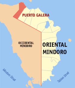 Map of Oriental Mindoro showing the location of Puerto Galera | |
.svg.png) Puerto Galera Location within the Philippines | |
| Coordinates: 13°30′N 120°57′E / 13.500°N 120.950°ECoordinates: 13°30′N 120°57′E / 13.500°N 120.950°E | |
| Country | Philippines |
| Region | Mimaropa (Region IV-B) |
| Province | Oriental Mindoro |
| District | 1st District of Oriental Mindoro |
| Founded | December 8, 1972 |
| Barangays | 13 |
| Government[1] | |
| • Mayor | Rockey D. Ilagan |
| Area[2] | |
| • Total | 247.85 km2 (95.70 sq mi) |
| Population (2010)[3] | |
| • Total | 32,521 |
| • Density | 130/km2 (340/sq mi) |
| Time zone | PST (UTC+8) |
| ZIP code | 5203 |
| Dialing code | +63 (0)43 |
| Income class | 1st Class; Partially Urban[4] |
| Website |
www |
Puerto Galera is the north-westernmost municipality in the province of Oriental Mindoro, Philippines. It is located at the south-western end of the Isla Verde Passage, about 130 kilometers (81 mi) south of Manila.
Barangays
Puerto Galera is politically subdivided into 13 barangays:[4]
- Aninuán
- Baclayán
- Balatero
- Dulangán
- Palangán
- Población
- Sabang
- San Antonio
- San Isidro (or white beach)
- Santo Niño
- Sinandigan
- Tabinay
- Villaflor
Demographics
| Population census of Puerto Galera | ||
|---|---|---|
| Year | Pop. | ±% p.a. |
| 1990 | 17,200 | — |
| 1995 | 19,485 | +2.36% |
| 2000 | 21,925 | +2.56% |
| 2007 | 28,035 | +3.45% |
| 2010 | 32,521 | +5.55% |
| Source: National Statistics Office[3] | ||
The National Statistical Coordination Board of the Philippines characterizes the municipality of Puerto Galera as First Class based on household income.[4] The municipality had a population of 32,521 in the 2010 Census of Population conducted by the National Statistics Office.[3]
Economy
The town has a number of business and commercial establishments. Candava Supermarket, New Virgo Grocery, Parkway Supermarket, Castillo Store are the popular supermarkets in Puerto Galera. Major banks include Philippine National Bank (PNB) Savings Bank, Rural Bank of Puerto Galera, Maxbank, and other microfinance banks.[5]
In addition, Mindoro is quickly becoming one of the key places in the development of renewable energy in the Philippines. With several large wind, hydroelectric, and geothermal projects under construction, the island hopes to be a net exporter of electricity by 2016.[6][7]
Telecommunication services are provided by Digital Telecommunications (Digitel), Smart Communications, and Globe. Cable and satellite television operators provide access to local and international broadcasts. Broadband Internet services are likewise available through the numerous internet cafes located in all barangays. Community radio stations Beach.fm and Flazh Radio also operate in the municipality
Environment
In the summer of 1998, extensive coral bleaching occurred around Medio Island and a large section of a shallow coral reef system (referred to as the "Coral Gardens") died. Since then the coral has regrown with a larger diversity of coral species replacing the prolific table corals. Corals in Puerto Galera were largely unaffected by the 2010 El Niño event.
In 2006 two super typhoons damaged the shallow reefs around Escarceo Point. A major section of the faster-growing coral species growing up to a depth of 6 metres (20 ft) was destroyed. This represented about 5% of the coral reef in the area. Extensive signs of new coral recruitment were noted in mid-2008. Acropora species (staghorn and table coral) rapidly recolonized the area so that most of the damaged coral has been replaced with new growth.
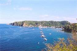
Tourism
This coastal town is well known among tourists for its numerous pocket beaches and many snorkeling and Scuba diving spots. The area was designated a Man and Biosphere Reserve of UNESCO in 1973 and has some of the most diverse coral reef diving in Asia. The marine environment has benefited in recent years due to income from tourism. This has seen a huge reduction in the number of fishermen in the area, as they gain higher revenue from tourists.
Puerto Galera is included in the list of the Club of the Most Beautiful Bays of the World, and is the only bay in the Philippines to be found there.[8]
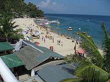
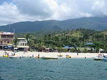
Among the beaches in Puerto Galera are Sabang Beach and White Beach, which have an active nightlife with numerous bars and restaurants.
Sabang Beach is the main destination for foreign tourists, while White Beach remains popular with local travelers. Big La Laguna Beach and Small La Laguna Beach are considered part of Sabang with resorts lining the beaches. Big La Laguna Beach is popular for local swimmers and snorkelers. Since 2001, White Beach has seen uncontrolled development. New restaurants and places to stay are rapidly encroaching on the beach itself. The town proper has relatively few attractions. It has a large central Catholic church and a pier area with some dining outlets.
Behind the beaches are the huge and generally unexplored mountain ranges of central Mindoro. A particular local attraction is the 9-hole golf course perched on the hillside above White Beach which commands spectacular views over Puerto Galera's natural harbor and the Verde Island Passage. Mangyan tribes are scattered over the mountainsides - some of the more remote tribes have virtually no contact with the outside world. Of the eight tribes on Mindoro, the Iraya are the largest. They are based in the Puerto Galera area.
Puerto Galera is among the top diving destination in the Philippines. Excellent diving is found less than 5 minutes from Sabang Beach. The diving generally focuses around the areas either side of Escarceo Point. Marine life is highly diverse. 180+ species of nudibranchs are found in the area and many species of fish can be seen. A variety of wrecks have been sunk over the years in addition to the one wreck of an engine of a WWII Japanese patrol boat.
Puerto Galera is also one of the main technical diving destinations in Asia. Technical Diving International - [TDI] has many dive centers in the area, offering the full range of TDI courses from Basic nitrox to advanced trimix.
Images
 Puerto Galera white beach
 White Beach at sunset, looking towards the north-east end
 Tamaraw Falls
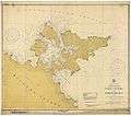 Nautical chart of Puerto Galera's harbor (1917)
References
- ↑ "Official City/Municipal 2013 Election Results". Intramuros, Manila, Philippines: Commission on Elections (COMELEC). 11 September 2013. Retrieved 23 December 2013.
- ↑ "Province: ORIENTAL MINDORO". PSGC Interactive. Makati City, Philippines: National Statistical Coordination Board. Retrieved 30 October 2012.
- 1 2 3 "Total Population by Province, City, Municipality and Barangay: as of May 1, 2010" (PDF). 2010 Census of Population and Housing. National Statistics Office. Retrieved 30 October 2012.
- 1 2 3 Municipality/City: PUERTO GALERA, National Statistics Coordination Board of the Philippines.
- ↑ http://amazingdudz.blogspot.sg/2012/01/atm-and-banking-in-puerto-galera.html
- ↑ Evora, Robert. "Mindoro wind farm dwarfs Ilocos plant". Manila Standard.
- ↑ "Mindoro Wind Farm Cleared". Manila Standard.
- ↑ Membership in the France-based Club of the Most Beautiful Bays of the World (Club des Plus Belles Baies du Monde) is obtained by application. The club is chartered to list only one bay per sea in a given country . The club lists the Bay of Puerto Galera (Baie de Puerto Galera) as being located at 13°3' NR, 120°75' in the E China Sea (southern) ("E Mer de Chine (sud)" in French).
External links
| Wikimedia Commons has media related to Puerto Galera. |
- Philippine Standard Geographic Code listing for Puerto Galera - National Statistical Coordination Board
- Local Governance Performance Management System
- Puerto Galera at DMOZ
 Puerto Galera travel guide from Wikivoyage
- 505th Squadron Philippine Coast Guard Auxiliary - 505th PCGA, Puerto Galera
 |
Tingloy, Batangas Isla Verde Passage |
Batangas City Isla Verde Passage |
| |
| Abra de Ilog, Occidental Mindoro | |
San Teodoro | ||
| ||||
| | ||||
| Mamburao, Occidental Mindoro | Santa Cruz, Occidental Mindoro |
Calapan (capital) | |
| Municipalities | |
| Component city | |
