Poltalloch, South Australia
| Poltalloch South Australia | |||||||||||||
|---|---|---|---|---|---|---|---|---|---|---|---|---|---|
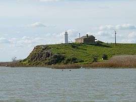 Lighthouse on Point Malcolm at the south-west end of Poltalloch | |||||||||||||
 Poltalloch | |||||||||||||
| Coordinates | 35°31′38″S 139°19′10″E / 35.52732°S 139.319360°ECoordinates: 35°31′38″S 139°19′10″E / 35.52732°S 139.319360°E | ||||||||||||
| Population | 407 (shared with other localities within the “State Suburb of Narrung”) (2011 census)[1] [lower-alpha 1] | ||||||||||||
| Established | 2002[2] | ||||||||||||
| Postcode(s) | 5259[3] | ||||||||||||
| Time zone | ACST (UTC+9:30) | ||||||||||||
| • Summer (DST) | ACST (UTC+10:30) | ||||||||||||
| Location | 87 km (54 mi) south-east of Adelaide | ||||||||||||
| LGA(s) | Coorong District Council[2] | ||||||||||||
| State electorate(s) | Hammond[4] | ||||||||||||
| Federal Division(s) | Barker[5] | ||||||||||||
| |||||||||||||
| |||||||||||||
| Footnotes |
Distances[3][2] Coordinates[2] Climate[6] Adjoining localities[2] | ||||||||||||
Poltalloch is a locality in the Australian state of South Australia located on land between the water bodies of Lake Alexandrina and Lake Albert about 87 kilometres (54 mi) south-east of the state capital of Adelaide.[3][2]
Poltalloch began as a private sub-division in the cadastral unit of the Hundred of Malcolm. Its boundaries were created in August 2000 in respect to “the long established name.”[2]
Poltalloch is bounded by Lake Alexandrina to the north, by Lake Albert to the south-west and by the Princes Highway to the south-east.[2] A road named the Poltalloch Road runs between the Princes Highway in the north along the coastline with Lake Alexandrina to Point Malcolm in the south-west where a ferry service operates to provide access to Narrung.[2][7] The principal land use within the locality is agriculture with a strip of land on the coastlines with both lakes being zoned for conservation purposes.[8]
The locality includes the following places listed on the South Australian Heritage Register - Point Malcolm Lighthouse, Poltalloch Homestead and Poltalloch Station Complex.[9][10][11]
Poltalloch is located within the federal division of Barker, the state electoral district of Hammond and the local government area of the Coorong District Council.[5][4][2]
References
- Notes
- ↑ For the 2011 census, the ‘State Suburb of Narrung’ consisted of the localities of Coorong (part), Meningie (part), Meningie West, Narrung and Poltalloch.
- Citations
- ↑ Australian Bureau of Statistics (31 October 2012). "Narrung". 2011 Census QuickStats. Retrieved 12 June 2016.
- 1 2 3 4 5 6 7 8 9 10 "Search result for "Poltalloch (Locality Bounded)" (Record no SA0058094) with the following layers selected - "Suburbs and Localities" and "Road Labels"". Government of South Australia. Retrieved 12 June 2016.
- 1 2 3 "Postcode for Poltalloch, South Australia". postcodes-australia.com. Retrieved 12 June 2016.
- 1 2 "District of Hammond Background Profile". Electoral Commission SA. Retrieved 12 June 2016.
- 1 2 "Commonwealth Electoral Division of Barker" (PDF). Australian Electoral Commission. Retrieved 12 June 2016.
- ↑ "Monthly climate statistics: Summary statistics Meningie". Commonwealth of Australia , Bureau of Meteorology. Retrieved 12 June 2016.
- ↑ Boating Industry Association of South Australia (BIA); South Australia. Department for Environment and Heritage (2005), South Australia's waters an atlas & guide, Boating Industry Association of South Australia, pp. 29 & 50, ISBN 978-1-86254-680-6
- ↑ "Development Plan, The Coorong District Council, Consolidated – 18 December 2014". Department of Planning, Transport and Infrastructure. pp. 157, 163, 224, 253, 257, 259, 264, 281, 285, 286, 289, 290 and 294. Retrieved 31 March 2016.
- ↑ "Original Poltalloch Homestead". South Australian Heritage Register. Department of Environment, Water and Natural Resources. Retrieved 12 June 2016.
- ↑ "Poltalloch Station Complex including Main House, Stables & Barn, Pump House, Overseers House, Engineers House, Boundary Riders Cottage, Station Hands Cottage, Shearing Shed and Jetty Store". South Australian Heritage Register. Department of Environment, Water and Natural Resources. Retrieved 12 June 2016.
- ↑ "Point Malcolm/Mundoo Lighthouse". South Australian Heritage Register. Department of Environment, Water and Natural Resources. Retrieved 12 June 2016.