Jabuk, South Australia
| Jabuk South Australia | |||||||||||||
|---|---|---|---|---|---|---|---|---|---|---|---|---|---|
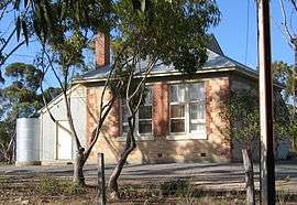 Former Jabuk school building | |||||||||||||
 Jabuk | |||||||||||||
| Coordinates | 35°23′S 140°04′E / 35.383°S 140.067°ECoordinates: 35°23′S 140°04′E / 35.383°S 140.067°E | ||||||||||||
| Postcode(s) | 5301 | ||||||||||||
| Time zone | ACST (UTC+9:30) | ||||||||||||
| • Summer (DST) | ACDT (UTC+10:30) | ||||||||||||
| Location | 10 km (6 mi) W of Geranium | ||||||||||||
| LGA(s) | Coorong District Council | ||||||||||||
| State electorate(s) | Hammond | ||||||||||||
| Federal Division(s) | Barker | ||||||||||||
| |||||||||||||
Jabuk is a former township situated 10 km west of Geranium on the Pinnaroo railway line and the Mallee Highway.
Jabuk appears to be named after the nearby Marmon Jabuk Range, but the origin of that name is unclear. It could be named from an Afghan word by a camelleer, or from a local Aboriginal word.
There is also a War Memorial, institute, football oval, tennis courts with lights and a play ground.
Churches


The Epiphany Lutheran Church, the foundation stone being laid on 7 February 1960 has long been closed. There is also a Baptist church which is no longer in use.
inhabitants
Jabuk has a population of 50-60 people including several close houses.
sporting
Jabuk has a running tennis club with a senior section its football oval is no longer in use and now it is used for farming and its clubrooms are used for wind ups for the Jabuk tennis team.