Peyrins
| Peyrins | |
|---|---|
|
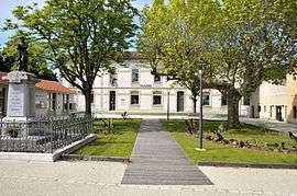
Town hall | |
 Peyrins | |
|
Location within Auvergne-Rhône-Alpes region  Peyrins | |
| Coordinates: 45°05′38″N 5°02′53″E / 45.0939°N 5.0481°ECoordinates: 45°05′38″N 5°02′53″E / 45.0939°N 5.0481°E | |
| Country | France |
| Region | Auvergne-Rhône-Alpes |
| Department | Drôme |
| Arrondissement | Valence |
| Canton | Romans-sur-Isère-1 |
| Intercommunality | Pays de Romans |
| Government | |
| • Mayor (2008–2014) | Alain Paret |
| Area1 | 25.16 km2 (9.71 sq mi) |
| Population (2008)2 | 2,435 |
| • Density | 97/km2 (250/sq mi) |
| Time zone | CET (UTC+1) |
| • Summer (DST) | CEST (UTC+2) |
| INSEE/Postal code | 26231 / 26380 |
| Elevation |
175–434 m (574–1,424 ft) (avg. 203 m or 666 ft) |
|
1 French Land Register data, which excludes lakes, ponds, glaciers > 1 km² (0.386 sq mi or 247 acres) and river estuaries. 2 Population without double counting: residents of multiple communes (e.g., students and military personnel) only counted once. | |
Peyrins is a commune in the Drôme department in southeastern France.
Population
| Historical population | ||
|---|---|---|
| Year | Pop. | ±% |
| 1911 | 1,346 | — |
| 1962 | 1,286 | −4.5% |
| 1968 | 1,302 | +1.2% |
| 1975 | 1,652 | +26.9% |
| 1982 | 1,882 | +13.9% |
| 1990 | 2,055 | +9.2% |
| 1999 | 2,309 | +12.4% |
| 2008 | 2,435 | +5.5% |
See also
References
| Wikimedia Commons has media related to Peyrins. |
This article is issued from Wikipedia - version of the 10/28/2016. The text is available under the Creative Commons Attribution/Share Alike but additional terms may apply for the media files.