Peabody, Kansas
| Peabody, Kansas | |
|---|---|
| City | |
|
1886 Peabody City Hall[1] (2010) | |
 Location within Marion County and Kansas | |
 KDOT map of Marion County (legend) | |
| Coordinates: 38°10′8″N 97°6′26″W / 38.16889°N 97.10722°WCoordinates: 38°10′8″N 97°6′26″W / 38.16889°N 97.10722°W[2] | |
| Country | United States |
| State | Kansas |
| County | Marion |
| Township | Peabody |
| Platted |
1871 (Coneburg) 1871, 1875 (Peabody) 1878 (North Peabody) |
| Incorporated | 1879 |
| Government | |
| • Type | Mayor–Council |
| • Mayor | Larry Larsen [3][4] |
| Area[5] | |
| • Total | 1.34 sq mi (3.47 km2) |
| • Land | 1.34 sq mi (3.47 km2) |
| • Water | 0 sq mi (0 km2) |
| Elevation[2] | 1,378 ft (420 m) |
| Population (2010)[6] | |
| • Total | 1,210 |
| • Estimate (2015)[7] | 1,144 |
| • Density | 900/sq mi (350/km2) |
| Time zone | CST (UTC-6) |
| • Summer (DST) | CDT (UTC-5) |
| ZIP code | 66866 [8] |
| Area code | 620, exchange 983 |
| FIPS code | 20-55100 [2] |
| GNIS ID | 477780 [2] |
| Website |
PeabodyKS |
|
| |

Peabody is a city in Marion County, Kansas, United States.[2] It is named after F.H. Peabody, of Boston, former vice-president of the Atchison, Topeka and Santa Fe Railway.[book 1] Peabody is well known in the region for its Independence Day Celebration on July 4,[9] and its historic 1880s downtown main street.[1] As of the 2010 census, the city population was 1,210.[10][11]
History

Early history
For many millennia, the Great Plains of North America was inhabited by nomadic Native Americans. From the 16th century to 18th century, the Kingdom of France claimed ownership of large parts of North America. In 1762, after the French and Indian War, France secretly ceded New France to Spain, per the Treaty of Fontainebleau.
19th century
In 1802, Spain returned most of the land to France. In 1803, most of the land for modern day Kansas was acquired by the United States from France as part of the 828,000 square mile Louisiana Purchase for 2.83 cents per acre.
In 1854, the Kansas Territory was organized, then in 1861 Kansas became the 34th U.S. state. In 1855, Marion County was established, which included the land for modern day Peabody.[12][book 2]
The first settler in the Peabody area was W.C. Coble, from North Carolina, who set up ranch headquarters a few miles east of Peabody in 1864.[13] The first settlement made in the area was in September 1870, by a colony of settlers from Wisconsin. In October, more settlers arrived. During the first month, the colony officers laid out a town on the north-half of section 4 township 22 and survived it into lots. The town was named Coneburg after the town company president John Cone. The town site was located between the current 9th Street and Division Avenue. During the winter of 1870, some of the settlers returned east to get supplies and bring out their families. In 1871, while the other settlers were gone, dissatisfaction arose in the community and it began to break up. Claim jumping of the Coneburg town site and nearby land started to occur, thus causing a legal mess.[book 2]
In 1870, T.M. Potter homesteaded the south-half of the same section of land. In spring of 1871, he and five other men started the Peabody town company. Since the land title for the Peabody town site had no legal disputes, businesses immediately moved from Coneburg.[book 2] In June 1871, the town of Peabody was platted, and it included the land where the railroad was built in the same month.[14]
A post office was established in Coneburg on January 25, 1871 then moved to Peabody on October 30, 1871.[15]
In April 1872, during legal disputes, Coneburg became North Peabody. A revised plat of Peabody was made in July 1875 and a supplemental plat of North Peabody was made in April 1878. Because of the disputes, the street that ran down the middle of the border between the two towns was called "Division Avenue". The two towns merged into the city of Peabody in 1879.[book 2]
The town of Peabody was named in 1871 after F.H. Peabody, of Boston, formerly vice-president of the Atchison, Topeka and Santa Fe Railway company.[book 1] [book 3] In May 1874, Mr. Peabody visited the new town, at which time he announced he would donate money for a library building, furniture, books, periodicals and landscaping if the Peabody township would secure four town lots for the site. The contract for construction was awarded in spring of 1875 and was opened to the public in June 1875, and the following February 1876 the state legislature authorized the township to levy a tax to support the library. The structure housed the library facilities until 1914 when a new Peabody Township Carnegie Library was constructed on the old location. [book 2] [16]

In 1871, the Atchison, Topeka and Santa Fe Railway extended a main line from Emporia through Peabody to Newton.[17] In 1996, it merged with Burlington Northern Railroad and renamed to the current BNSF Railway. Most locals still refer to this railroad as the "Santa Fe". The first depot was built south of the tracks, then later a train wreck destroyed it, so a second depot was built on the north side of the tracks.[13] In 1873, three west-bound trains (9:05AM, 1:00PM, 8:30PM) and three east-bound trains (4:42AM, 6:50PM, 8:30PM) stopped at the Peabody depot.[18] Rail service was still very strong five decades later. In 1925, three west-bound and four east-bound trains made stops at Peabody.[13] The second depot was demolished in the 1970s after passenger transportation ended, then its land was converted into the Santa Fe Park, which is located at the south end of Walnut Street. Currently Amtrak's Southwest Chief passenger train currently passes through Peabody twice each day, but stops at nearby Newton.
During most of the 1870s, the railway depots in Peabody and Florence were the only access points for train passengers into Marion County and northern Butler County. Peabody was a destination for numerous foreign homesteaders, including the Mennonite settlers around Goessel and Gnadenau.[19][20]
In 1887, the Chicago, Kansas and Nebraska Railway built a branch line north-south from Herington through Peabody to Caldwell.[21] By 1893, this branch line was incrementally built to Fort Worth, Texas. It foreclosed in 1891 and was taken over by Chicago, Rock Island and Pacific Railway, which shut down in 1980 and reorganized as Oklahoma, Kansas and Texas Railroad, merged in 1988 with Missouri Pacific Railroad, and finally merged in 1997 with Union Pacific Railroad. Most locals still refer to this railroad as the "Rock Island". Its depot in Peabody was demolished in the early 1960s.[13][22]
In 1875, Peabody held its first agricultural "county fair" and continued to hold them annually for many years.[23] In September 1885, the Kansas State Fair was held at Peabody during the first four days of the month. An outstanding feature of the state fair was "the First Monument to General Grant", who died shortly before the fair. The temporary monument was an obelisk about 40 feet (12 m) tall, and built from forty bushels of ears of corn. The fair had a grandstand, which could hold 2000 people, to view horse races. The race track was used for a variety of events, including horse walking teams in harness, trotting, running, pacing, mule racing, and daily chariot races. A dining hall was built that was capable of feeding 10,000 people each day. In 1900, the Marion County Agricultural Society sold the fair grounds to the city, which renamed it the Peabody City Park, and its entrance is located at the corner of Locust and 2nd Streets.[13][24]
Peabody was the home of famous race horses around the turn of the century. Three of the more famous horses were world champions. Joe Young (known as the "iron horse") sold for $10,000 by C.E. Westbrook, the first horse west of the Mississippi River to sell for such a high price. Joe Young sired Joe Patchen in 1889, who earned his owner $40,000 in race purses and then was sold for $44,000. Joe Patchen sired Dan Patch in 1896, a horse that sold in 1907 for $60,000. Other famous local racing horses included trotters McKinney, and Silver Sign. Silverthorne toured Austria where he competed for three years against the best race horses in Europe.[25][26]
20th century

Peabody became an important supply point for one of the state's cattle feeding districts. By 1911, approximately 20,000 head of cattle were imported from other states and fed within 20 miles (32 km) of Peabody at 50 farms. Because of this cattle industry, local farmers grew more corn, alfalfa, and other feed crops during the 1900s and 1910s.[27]
Peabody and Watchorn areas experienced an oil boom from 1918 to 1920 in the oil fields of the Mid-Continent oil province. The influence of the petroleum industry remained strong in Peabody, and resulted in the greatest change upon the community in the shortest time. More than 100 residences were constructed in October and November 1919. From 1918 to 1919, the population increased by 75% or more, but later decreased as oil booms in other Kansas areas needed the workers. Currently Watchorn is a ghost town consisting of oil wells but no remaining historical structures.
The New Santa Fe Trail road was routed through Peabody in the late 1910s. The road entered the north-east side of the city on Old Mill Rd, and exited on the south-west side on 60th Street (known as the Old Trail).[28][29] The trail became U.S. Route 50 in the late 1930s when the new highway was routed east to west on 9th Street. In 1998, the highway was moved about 1.5 blocks north so it could go over a new railroad overpass.[30]
In 1943, German and Italian prisoners of World War II were brought to Kansas and other midwest states as a means of solving the labor shortage caused by American men serving in the war effort. Large prisoner-of-war camps camps were established in Kansas at Camp Concordia, Camp Funston (at Fort Riley), and Camp Phillips (at Salina under Fort Riley). Fort Riley established 12 smaller branch camps, including Peabody and El Dorado.[31][32] Up to 150 prisoners were quartered at the Peabody branch camp.[13] Farmers were to have first priority over other industries in requesting prisoner labor. County agents were responsible for processing the application of local residents seeking the use of the prisoners who were to be available only as group laborers. No fewer than four prisoners could be assigned to any farm, and one guard accompanied each group, but later it was common for no guards to accompany the prisoners. The prisoners were not allowed to operate any powered farm equipment. The farmer collected the workers at the camp and returned them at the end of each day. The Peabody branch camp #101 was located in the Eyestone building, now occupied by Heckendorn Equipment Company, and located at 122 West 2nd Street.[13] The prisoner yard was located in the north-east corner of the property and still exists as a storage area. The camp was closed in December 1945, after Germany surrendered.[13]
There has been numerous floods during the history of Peabody. In June and July 1951, due to heavy rains, rivers and streams flooded numerous cities in Kansas, including Peabody. Many reservoirs and levees were built in Kansas as part of a response to the Great Flood of 1951.
The community gradually increased in size as a commuter town to support aircraft industries in Wichita during World War II and Soviet Union Cold War years. Over time, the aircraft industry worker requirement has shrank, thus has their influence on numerous commuter towns. Another gradual impact on the community has been the decrease in the size of farm families. Over time as farm equipment has increased in size, so has it decreased the number of family farms in the area, because fewer people are required to farm larger amounts of land. Fewer farms families has led to a gradual decrease in children at local schools. Peabody, like most rural towns, has seen a gradual loss of population do to rural flight to larger cities.
The community has always had great pride in celebrating and promoting its past. Three centennials, Kansas centennial in 1961, Peabody centennial in 1971, United States Bicentennial in 1976, caused surges of historic pride, which eventually led to the creation of the Peabody Main Street Association (PMSA) in 1989 and the Peabody Community Foundation (PCF).[33] The Peabody Main Street Association has won numerous awards since it was founded.[34]
In 1998, the downtown area of Peabody was placed on the National Register of Historic Places (NRHP), and known as the Peabody Downtown Historic District.[1] Peabody had four previous listings on the NRHP: Peabody Historical Library Museum (in 1973), Peabody Township Library (in 1987), J.S. Schroeder Building (in 1991), and W.H. Morgan House (in 1996).
21st century
In 2010, the Peabody Main Street Association received 5 state awards.[34] In the same year, the Keystone-Cushing Pipeline (Phase II) was constructed 4.5 miles (7.2 km) east of Peabody, north to south through Marion County, with much controversy over road damage, tax exemption, and environmental concerns (if a leak ever occurs).[35][36][37]
In 2012, the Peabody City Park was placed on the National Register of Historic Places (NRHP), the sixth in Peabody.[24][38]
Geography
Peabody is located at 38°10′8″N 97°6′26″W / 38.16889°N 97.10722°W (38.168793, −97.107171)[2] near the western edge of the Flint Hills[39] in the Great Plains of the United States. According to the United States Census Bureau, the city has a total area of 1.34 square miles (3.47 km2), all of it land[5] except Doyle Creek and Spring Creek.
Peabody is approximately 15 mi (24 km) north-east of Newton, 42 mi (68 km) north of Wichita, 164 mi (264 km) south-west of Kansas City. The north-east corner of Harvey County is 2.0 miles (3.2 km) west of Peabody.
Climate
On average in Peabody, January is the coolest month with an average low of 19 °F (-7 °C), July is the warmest month with an average high of 92 °F (33 °C), and May is the wettest month with an average precipitation of 4.64 in. The hottest temperature recorded in Peabody was 115 °F (43 °C) in 1954; the coldest temperature recorded was -22 °F (-31 °C) in 1989.[40]
| Climate data for Peabody, Kansas | |||||||||||||
|---|---|---|---|---|---|---|---|---|---|---|---|---|---|
| Month | Jan | Feb | Mar | Apr | May | Jun | Jul | Aug | Sep | Oct | Nov | Dec | Year |
| Record high °F (°C) | 76 (24) |
82 (28) |
91 (33) |
95 (35) |
101 (38) |
112 (44) |
115 (46) |
111 (44) |
109 (43) |
97 (36) |
88 (31) |
78 (26) |
115 (46) |
| Average high °F (°C) | 41 (5) |
48 (9) |
59 (15) |
69 (21) |
77 (25) |
86 (30) |
92 (33) |
91 (33) |
82 (28) |
71 (22) |
55 (13) |
44 (7) |
67.9 (20.1) |
| Average low °F (°C) | 19 (−7) |
24 (−4) |
34 (1) |
44 (7) |
53 (12) |
63 (17) |
68 (20) |
66 (19) |
58 (14) |
46 (8) |
33 (1) |
23 (−5) |
44.3 (6.9) |
| Record low °F (°C) | −17 (−27) |
−20 (−29) |
−6 (−21) |
12 (−11) |
27 (−3) |
40 (4) |
45 (7) |
45 (7) |
24 (−4) |
10 (−12) |
−9 (−23) |
−22 (−30) |
−22 (−30) |
| Average precipitation inches (mm) | 0.82 (20.8) |
0.96 (24.4) |
2.52 (64) |
2.82 (71.6) |
4.64 (117.9) |
4.49 (114) |
3.79 (96.3) |
3.33 (84.6) |
3.24 (82.3) |
2.53 (64.3) |
2.17 (55.1) |
1.07 (27.2) |
32.38 (822.5) |
| Source: The Weather Channel;[40] National Weather Service | |||||||||||||
Demographics
| Historical population | |||
|---|---|---|---|
| Census | Pop. | %± | |
| 1880 | 1,087 | — | |
| 1890 | 1,474 | 35.6% | |
| 1900 | 1,369 | −7.1% | |
| 1910 | 1,416 | 3.4% | |
| 1920 | 2,455 | 73.4% | |
| 1930 | 1,491 | −39.3% | |
| 1940 | 1,367 | −8.3% | |
| 1950 | 1,194 | −12.7% | |
| 1960 | 1,309 | 9.6% | |
| 1970 | 1,368 | 4.5% | |
| 1980 | 1,474 | 7.7% | |
| 1990 | 1,349 | −8.5% | |
| 2000 | 1,384 | 2.6% | |
| 2010 | 1,210 | −12.6% | |
| Est. 2015 | 1,144 | [7] | −5.5% |
| U.S. Decennial Census | |||
2010 census
As of the census[6] of 2010, there were 1,210 people, 478 households, and 299 families residing in the city. The population density was 903.0 inhabitants per square mile (348.7/km2). There were 566 housing units at an average density of 422.4 per square mile (163.1/km2). The racial makeup of the city was 93.2% White, 1.6% African American, 1.2% Native American, 0.2% Asian, 0.1% Pacific Islander, 0.8% from other races, and 2.8% from two or more races. Hispanic or Latino of any race were 3.3% of the population.
There were 478 households of which 27.8% had children under the age of 18 living with them, 50.4% were married couples living together, 7.7% had a female householder with no husband present, 4.4% had a male householder with no wife present, and 37.4% were non-families. 32.8% of all households were made up of individuals and 15.3% had someone living alone who was 65 years of age or older. The average household size was 2.33 and the average family size was 2.94.
The median age in the city was 45.8 years. 22.2% of residents were under the age of 18; 6.2% were between the ages of 18 and 24; 20.1% were from 25 to 44; 29.5% were from 45 to 64; and 21.8% were 65 years of age or older. The gender makeup of the city was 50.3% male and 49.7% female.
2000 census
As of the census[41] of 2000, there were 1,384 people, 531 households, and 346 families residing in the city. The population density was 1,124.7 people per square mile (434.4/km²). There were 602 housing units at an average density of 489.2 per square mile (189.0/km²). The racial makeup of the city was 95.81% White, 1.52% African American, 0.43% Native American, 0.36% from other races, and 1.88% from two or more races. Hispanic or Latino of any race were 2.82% of the population.
There were 531 households out of which 30.7% had children under the age of 18 living with them, 53.9% were married couples living together, 7.7% had a female householder with no husband present, and 34.7% were non-families. 31.8% of all households were made up of individuals and 16.9% had someone living alone who was 65 years of age or older. The average household size was 2.37 and the average family size was 3.01.
In the city the population was spread out with 24.6% under the age of 18, 5.3% from 18 to 24, 24.4% from 25 to 44, 24.0% from 45 to 64, and 21.6% who were 65 years of age or older. The median age was 42 years. For every 100 females there were 93.6 males. For every 100 females age 18 and over, there were 88.9 males.
As of 2000 the median income for a household was $29,792, and the median income for a family was $37,250. Males had a median income of $28,750 versus $19,028 for females. The per capita income for the city was $15,493. About 6.3% of families and 14.2% of the population were below the poverty line, including 9.6% of those under age 18 and 17.6% of those age 65 or over.
Economy
The largest employer in Peabody is Unified School District 398, which has two schools in the city.
Area events
- July 4th Celebration[42][43] 92nd annual in 2013, fireworks are displayed in the historic Peabody City Park (near Locust and 2nd streets).[24] The fireworks are infamous for the ending display called the Battle of New Orleans, which explodes over 1 Million individual items.[44] In the 1960s and 1970s, up to 30,000 or more people attended the event, including a Carnival of rides.[9][45]
- Doyle Valley Farmers Market, Santa Fe Park (near Walnut and 1st streets), Memorial Day to Labor Day, 8AM to Noon.
Area attractions

Peabody has six listings on the National Register of Historic Places (NRHP).
- 1880's Peabody Downtown Historic District (NRHP).[46] The Downtown Business District of Peabody boasts of 42 contributing buildings in the district. The significant period for the district began in 1874 with the construction of the first free public library and ended in 1922 with the decline in oil production. Peabody is the 2nd community in the State of Kansas to have its entire downtown district on the National Register of Historic Places.[47]
- 1884 J.S. Schroeder Building (NRHP),[48] 111 North Walnut Street. This first floor has been many types of businesses, but most older locals remember it as the McMillen grocery store. For the past couple of decades, the first floor has been occupied by the Mayesville Mercantile.
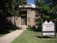
- 1914 Peabody Township Carnegie Library (NRHP),[49] 214 North Walnut Street.[47]
- 1919 Eyestone building, previously a POW camp during World War II, 122 West 2nd Street, private business.[13]
- Peabody Museum Historical Complex,[50] Memorial Day to Labor Day.
- 1874 Peabody Historical Library Museum (NRHP),[16] 106 East Division Avenue (east of Carnegie Library). After the new Carnegie library was built in 1914, the first library was moved and used for club meetings and stood idle for a number of years. In 1960, while planning for the 1961 Kansas centennial celebration, local citizens organized to move the structure to a lot near its original location. The old library building was converted and dedicated as a museum on July 3, 1961.
- 1881 W.H. Morgan House (NRHP),[51] 212 North Walnut Street. A two-story Queen Anne Cottage built by W.H. Morgan, first editor of the Peabody Gazette newspaper.[47][52]
- 1904 W.H. Morgan Barn, east of House. Will contain larger items that can't fit in the museum. Not open to public yet.
- 1920 Peabody Printing Museum,[53] 210 North Walnut Street. The Peabody Printing Museum has a collection of hot type equipment dating from 1870 to 1920.
- Peabody City Park (NRHP):[24]
- 1887 T.B. Townsend Barn, several miles east near U.S. Route 50. It is a three-story, 80 feet by 140 feet, limestone barn, and can easily be seen on the north side of the highway. Not open to public.[54][55][56] [book 4]
- 1927 Indian Guide Monument,[13] several miles east near U.S. Route 50. Can be seen on bluff over-looking south side of highway. Not open to public.
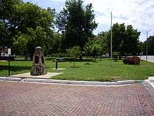
- 1974 Mennonite Centennial Memorial Monument, south-east corner of Walnut and 1st Streets in the Santa Fe Park. A Threshing stone was cut and placed on 4 sides of this monument.[20]
- Marion Reservoir, approximately 13 miles (21 km) north of Peabody.
Films
- Small Town, USA, a feature documentary,[57] currently in pre-production,[58] examines the challenges faced by communities, employers and individuals as they strive to develop cultural and economic models that will ensure survival. IMG Pictures filmed in many small towns in rural Kansas, including Peabody.[59] The Peabody downtown is being used for the promotional picture.[60]
Government
The Peabody government consists of a mayor and five council members. The council meets the 2nd and last Monday of each month at 7 pm.[3][4]
- City Hall, 300 North Walnut Street.
- Fire Department, 103 North Sycamore Street.
- Police Department and City Shop, 107 East 9th Street.
- U.S. Post Office, 105 West 2nd Street.
Historical list of Mayors
|
Note: Before 1905, terms were 1 year. |
Note: Before 1905, terms were 1 year. |
Education


Primary and secondary education
Peabody is part of Unified School District 398.[66] The school district includes Peabody, Burns, Wonsevu, and nearby rural areas of Marion / Chase / Harvey / Butler Counties. The district has two schools in Peabody:
- Peabody-Burns Junior/Senior High School, 810 North Sycamore Street, Grades 6th to 12th.
- Peabody-Burns Elementary School, 506 North Elm Street, Grades Pre-K to 5th.
Academics
The high school band is well known in regional competitions and parades. The high school is a member of T.E.E.N., a shared video teaching network, started in 1993, between five area high schools.[67]
Sports
The Peabody-Burns High School mascot is the Warrior. All high school athletic and non-athletic competition is overseen by the Kansas State High School Activities Association. For the 2010/2011 seasons, the football team competes as Class 8 Man - Division I in the Wheat State league.[68]
Championships
- 1977, 2nd Place, Class 2A, High School Boys Football, Head Coach Dennis Franchione.[69][70][71]
- 1963, 1st Place, Class B, High School Boys Basketball, Head Coach Cal Reimer.[72][73]
History
The first school in Peabody was organized in 1871. The first school building, two stone rooms, was built in 1872. The first high school classes were taught in 1879, and the first graduation class in 1881 consisted of 2 students.[13] In 1923, a new high school was built at 900 North Walnut Street.[13] In 1946-1947, the School Reorganization Act consolidated many one-room rural schools into the Peabody school district.[13] In 1953, the Brown Building was built to house a larger gymnasium, band / lunch room, and vocational agriculture rooms.[13] In 1965, the Burns and Summit school districts were unified with Peabody to form Unified School District 398.[13] The Summit school and Burns High School were closed. In 1996-1997, the current high school was built (and attached) to the south side the existing Brown Building at 810 North Sycamore Street. Soon afterward, the former 1923 high school across the street was demolished and converted into a football practice field. The Burns Grade School, which included a junior high, was closed.[13] Currently all students in USD 398 attend schools in Peabody.
Library
Each USD 398 school has a library for student access.
The city is served by the Peabody Township Carnegie Library at 214 North Walnut Street. The library was established in 1874, a Carnegie library since 1914, was the first free tax-supported library in Kansas.[16][49] Since 2008, two computers have been available for high-speed T1 internet access, and free WiFi access allow patrons to browse the internet. The library is a member of the North Central Kansas Libraries System, which provides an inter-library book loan service between its members.
Media
- Peabody Gazette-Bulletin, local newspaper in Peabody.
- The Newton Kansan, regional newspaper in Newton.
- The Wichita Eagle, major regional newspaper in Wichita.
Radio
Peabody is served by numerous AM and FM radio stations of the Wichita-Hutchinson listening market area,[74] and satellite radio. See Media in Wichita, Kansas.
Television
Peabody is served by over-the-air ATSC digital TV of the Wichita-Hutchinson viewing market area,[75] cable TV by Allegiance Communications, and satellite TV. See Media in Wichita, Kansas.
Infrastructure
Transportation
Rail
Two railroads, BNSF Railway and Union Pacific Railroad, pass through the city. The BNSF Railway runs east-west through the city and has a spur for grain cars at the east Mid Kansas Co-Op.[76] Amtrak's Southwest Chief passenger train travels on the BNSF Railway but stops at nearby Newton.[77] The Oklahoma Kansas Texas (OKT)[78] line of the Union Pacific Railroad runs north-south through the city and has a spur for grain cars at the west Mid Kansas Co-Op.[79] The two railroads cross each other as a Level junction, and a rarely used connection between the two railroads allows eastbound BNSF trains to turn onto the northbound Union Pacific railroad. Both railways previously had depots in Peabody, but were demolished in the 1960s and 1970s.[13]
Highways
![]() U.S. Highway 50 passes through the northern edge of the city and follows roughly parallel to the BNSF Railway.[80]
U.S. Highway 50 passes through the northern edge of the city and follows roughly parallel to the BNSF Railway.[80]
In the early years of the highway before U.S. Route 50 was finalized in the late 1930s, the highway was known as the New Santa Fe Trail, which entered the north side of the city on Newell Rd (later on Old Mill Rd), and exited on the south-west side on 60th Street (known as the Old Trail).[28][29] Up until the late 1950s, U.S. Route 50 was split into two routes through central Kansas. The routes were called 50N and 50S, and the highway through Peabody was 50S. From the late 1930s to 1998, the highway was routed east to west through Peabody on 9th Street, then a bypass and overpass was built about 1.5 blocks north to avoid a dangerous underpass which went under the Union Pacific Railroad.[30]
It has been proposed, by the Kansas Department of Transportation, that U.S. Route 50 should be converted into a 4-lane expressway from Emporia to western Kansas. In the meantime, additional passing lanes may be added.[81]
Utilities
- Internet
- Cable is provided by Allegiance Communications.
- Wireless is provided by Pixius Communications and various cellular providers.
- Satellite is provided by HughesNet, StarBand, WildBlue.
- Dialup is provided by AT&T, EarthLink / Southwind, InterKan, KITUSA / Carroll's Web, WWWebservice.
- TV
- Cable is provided by Allegiance Communications.
- Satellite is provided by DirecTV, Dish Network.
- Terrestrial is provided by regional digital TV stations.
- Telephone
- Landline is provided by AT&T.
- Cell Phone is provided by Verizon.
- Electricity
- City is provided by Westar Energy.
- Rural is provided by Flint Hills RECA and Butler REC.
- Natural Gas
- Service is provided by Atmos Energy.
- Water
- City is provided by City of Peabody.
- Rural is provided by Harvey County RWD #1.
- Sewer
- Service is provided by City of Peabody.
- Trash
- Service is provided by Waste Connections.
Notable people

- C. M. Arbuthnot (1852-1920), physician, founder of Arbuthnot Drug Company, Principal at public school in Peabody for two years.[82][83]
- James Henry Clay Brewer (1838-1927),[84] Kansas House of Representatives in 1889,[85] Captain in Union Army, Peabody merchant.[86]
- Edgar Francis Davison (1857-1939),[87] Kansas House of Representatives in 1905 and 1907,[85] banker.
- Rebecca Lee Ediger (born 1952), United States Secret Service agent, Special Award for Distinguished Service to the Executive Office of the President.[88][89]
- Dennis Wayne Franchione (born 1951), head college football coach at Southwestern College, Pittsburg State University, University of New Mexico, Texas Christian University, University of Alabama, Texas A&M University, Texas State University. Head football coach of Peabody High School from 1976 to 1977.[90]
- John Gilmore Johnson (1852-1921),[91] Campaign Committee for William Jennings Bryan during 1896 presidential election, Kansas Delegate for Democratic National Committee in 1896 / 1900, various Democratic Committees for 1900 / 1904 / 1908 elections, Peabody postmaster.[13][92][93]
- Orlando Jolliffe (1858-1946), Kansas House of Representatives in 1901 / 1919 / 1921 / 1925 / 1927,[85] Marion County Commissioner,[94] Mayor of Peabody in 1917-1918, banker,[64] oilman,[95] rancher,[13] Jolliffe Hall at University of Kansas was named after him in 1942.[96][97]
- Alfred R. Kent (1874-1947),[98] Kansas House of Representatives in 1917.[85][97]
- Frank H. Kollock (1846-1895), also spelled Kolloch, Kansas House of Representatives in 1879,[85] Mayor of Peabody in 1881, attorney, banker (organized first bank of Peabody in 1874).[97][99]
- Willard J. Madsen (born 1930), professor emeritus at Gallaudet University, sign language expert, author of two sign language text books.[100][101][102][103]
- Dick Myers (born 1945), Forward for 1965–66 Texas Western Miners men's basketball team, inducted into Naismith Memorial Basketball Hall of Fame in 2007.[104][105]
- Fred Eugene Pettit (1861-19xx), Kansas House of Representatives in 1915,[85] Peabody merchant.[106][107][108][109][110]
- Bertine B. Pinkney (1824-1909),[111] also spelled Pinckney, Kansas House of Representatives in 1874,[85] Wisconsin State Assembly, Wisconsin Senate, Colonel in Union Army,[book 2] Postmaster in Peabody starting in 1877, farmer.[13]
- T.M. Potter (1840-1929),[112] Kansas Senate in 1909 and 1911,[85] Infantry in Union Army,[book 2] rancher, school teacher in Marion, original owner of south half-section of Peabody, organized Peabody town company,[13] member of Board of Regents of University of Kansas, Potter Lake at University of Kansas was named after him in 1910.[110][113]
- Frederic Sackrider Remington (1861-1909),[114] American Old West artist, sheep rancher.[13][115] Note: His ranch was closer to what is today the city of Whitewater, which didn't exist in 1883 when he moved to the area.
- Ethan Andrew Schmidt (1975-2015), assistant professor of history at Delta State University, American history author of “Native Americans in the American Revolution" (2015) and "The Divided Dominion: Social Conflict and Indian Hatred in Early Virginia" (2014).[116][117][118][119]
- Ron Slaymaker (born 1936), member of 4 sports hall of fames, Emporia State University basketball coach, high school basketball and football coach.[120]
- Lawrence David Slocombe (1905-1972),[121] Kansas House of Representatives from 1956 to 1972,[85] rancher, farmer, businessman.[122][123]
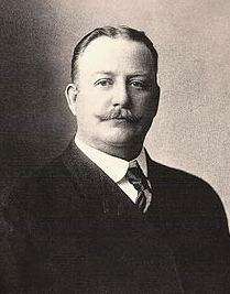
- Oscar Stanley Stauffer (1886-1982),[124] founder of Stauffer Communications, editor of Peabody Gazette-Herald newspaper from 1915 to 1922.[13]
- Kaycee Nicole Swenson, fictitious persona, well-known case of Münchausen by Internet from 1999 to 2001.[125][126]
- William Wallace Waring (1823-1907),[127] Kansas House of Representatives in 1881.[85]
- William Dale Weidlein (1892-1983),[128] aka "Bill, sixth head football coach for Fort Hays State University Tigers. His uncle, Philip Weidlein, was Mayor of Peabody in 1879.
Famous visitors
- William Jennings Bryan, politician and speaker, gave speeches in Peabody on multiple occasions while Democratic candidate for President of the United States in 1896, 1900, 1908 because his friend and advisor J.G. Johnson lived in Peabody (see notable people section).[13]
Gallery
- Historic Images of Peabody, Special Photo Collections at Wichita State University Library
 Downtown Peabody (looking south) (2010)
 First Baptist Church (looking north) (2010)
 Prairie Lawn Cemetery, north-east of Peabody (looking east) (2010)
See also
- Peabody Township, Marion County, Kansas (south of 9th Street in Peabody)
- Catlin Township, Marion County, Kansas (north of 9th Street in Peabody)
- Peabody-Burns Junior/Senior High School
- Main Street Programs in the United States
- List of Grand Army of the Republic Posts in Kansas
- National Register of Historic Places listings in Marion County, Kansas
- Threshing Stone
- Sunflower Theater
- Historical Maps of Marion County, Kansas
- La Junta Subdivision, branch of the BNSF Railway
Further reading

- The Women of Peabody; Peabody Historical Society; Mennonite Press; LCCN 2010928692; 250 pages; 2010.
- The Germans We Trusted: Stories Which Had To Be Told...; Pamela Taylor; Lutterworth Press; 192 pages; 2003; ISBN 978-0-7188-3034-2. (WWII POW camp history)
- Townsend Ranch History, 1870-1987; Carl F. and Helen Hansen; 1990.
- As I Remember; Jane Huguenin Good; 269 pages; 1982.
- St Paul's Lutheran Church, Peabody, Kansas, 1877-1977, 100th Anniversary Service, Centennial Celebration; St Paul's Lutheran Church; 1977.
- Peabody Centennial. The Years Through 1871-1971: Commemorative Centennial Program.; 1971.
- The Wealth She Gathered; Helen Marie (Lyon) Cooper; Chapman & Grimes; 260 pages; 1950; A47332. (wife of George Cooper)
- History of Peabody; A.H. Lackey; Peabody Gazette; July 7, 1876.
References
- Books
- 1 2 Kansas : A Cyclopedia of State History, Embracing Events, Institutions, Industries, Counties, Cities, Towns, Prominent Persons, Etc; 3 Volumes; Frank W. Blackmar; Standard Publishing Co; 944 pages; 1912. (54MB PDF) (Volume2, 955 pages, 53MB PDF), (Volume3, 824 pages, 33MB PDF)
- 1 2 3 4 5 6 7 History of the State of Kansas; William G. Cutler; A.T. Andreas Publisher; 1883.
- ↑ Atchison, Topeka, and Santa Fe Railway : Annual Meetings, and Directors and Officers : Volumes 7; AT&SF Railway; 1902. (12MB PDF)
- ↑ Townsend Ranch History; Carl and Helen Hansen; Located at Peabody Township Library; 14 pages; 1990.
- Other
- 1 2 3 4 5 6 Peabody Downtown Historic District - NRHP Application (2.1MB PDF)
- 1 2 3 4 5 6 Geographic Names Information System (GNIS) details for Peabody, Kansas; United States Geological Survey (USGS); October 13, 1978.
- 1 2 3 Peabody - Directory of Public Officials
- 1 2 3 Peabody - Government
- 1 2 "US Gazetteer files 2010". United States Census Bureau. Archived from the original on January 24, 2012. Retrieved 2012-07-06.
- 1 2 "American FactFinder". United States Census Bureau. Retrieved 2012-07-06.
- 1 2 "Annual Estimates of the Resident Population for Incorporated Places: April 1, 2010 to July 1, 2015". Retrieved July 2, 2016.
- ↑ United States Postal Service (2012). "USPS - Look Up a ZIP Code". Retrieved 2012-02-15.
- 1 2 Mr Fireworks - Whistler lives on through the pyrotechnic tradition he created in Peabody, page B2; Peabody Gazette-Bulletin; 18 pages; July 1, 2015.
- ↑ "2010 City Population and Housing Occupancy Status". U.S. Census Bureau. Archived from the original on July 21, 2011. Retrieved March 6, 2011.
- ↑ "American FactFinder". United States Census Bureau. Archived from the original on 2013-09-11. Retrieved 2011-05-14.
- ↑ The History of Marion County and Courthouse
- 1 2 3 4 5 6 7 8 9 10 11 12 13 14 15 16 17 18 19 20 21 22 23 24 25 26 27 28 29 30 31 32 33 34 35 36 37 38 39 40 41 42 43 44 45 46 47 48 49 50 51 52 53 54 55 56 57 58 59 60 61 Peabody : The First 100 Years; Peabody Historical Society; Peabody Gazette-Herald in Peabody, KS; 123 pages; 1971.
- ↑ AT&SF Railroad History in Kansas
- ↑ "Kansas Post Offices, 1828-1961 (archived)". Kansas Historical Society. Archived from the original on October 9, 2013. Retrieved 14 June 2014.
- 1 2 3 National Register of Historic Places - Peabody Historical Library Museum (2MB PDF)
- ↑ Santa Fe Rail History
- ↑ Santa Fe Train Time Table For 1873
- ↑ Settlement of the Krimmer Mennonite Brethren; Alberta Pantle; Kansas Historical Quarterly; February 1945 (Vol 13, No 5); pages 259 to 285.
- 1 2 3 Mennonite Centennial Memorial Monument unveiled at Santa Fe park, page 1; Peabody Gazette-Bulletin; ? pages; August 1, 1974.
- ↑ Rock Island Rail History
- ↑ Photo of Peabody Rock Island Depot; 1963.
- ↑ Poster from Seventh Annual Agriculture Fair At Peabody From September 28-30, 1881
- 1 2 3 4 5 6 Recent nominees for National Register of Historic Places; The Wichita Eagle; December 6, 2011.
- ↑ C.E. Westbrook - Bio
- ↑ Drawing of Trotting Stallion Joe Young; 1887.
- ↑ Henry Stephen - Feed lot history; Peabody News; 1901.
- 1 2 1918 Kansas Highway Map; KSDOT.
- 1 2 1932 Kansas Highway Map; KSDOT.
- 1 2 U.S. Route 50 Peabody bypass map; KSDOT; 1998.
- ↑ List of Prisoner Of War (POW) Camps in Kansas
- ↑ An Army Hospital: From Horses to Helicopters, Fort Riley, 1904-1957; Kansas Historical Quarterly; Spring 1958 (Vol. XXIV, No. 1)
- ↑ Peabody Main Street Association.
- 1 2 Peabody Main Street Association wins 5 state awards
- ↑ Keystone Pipeline - Marion County Commission calls out Legislative Leadership on Pipeline Deal; April 18, 2010.
- ↑ Keystone Pipeline - TransCanada inspecting pipeline; December 10, 2010.
- ↑ Keystone Pipeline - County ask TransCanada for pipeline emergency plan; Hillsboro Free Press; February 15, 2011.
- ↑ NRHP Property Weekly List Changes; National Park Service (NPS); January 20, 2012.
- ↑ Flint Hills - Introduction; GeoKansas - Kansas University.
- 1 2 "Average weather for Peabody, KS". The Weather Channel. Retrieved 2010-06-28.
- ↑ "American FactFinder". United States Census Bureau. Archived from the original on 2013-09-11. Retrieved 2008-01-31.
- ↑ Peabody Area Events
- ↑ July 4th Regional TV Commercial - YouTube Video
- ↑ July 4th Battle Of New Orleans on July 2010 - YouTube Video
- 1 2 Peabody City Park History
- ↑ National Register of Historic Places - Peabody Downtown Historic District (10MB PDF)
- 1 2 3 Area Attractions
- ↑ National Register of Historic Places - J.S. Schroeder Building (4MB PDF)
- 1 2 National Register of Historic Places - Peabody Township Carnegie Library (5MB PDF)
- ↑ Peabody Museum Historical Complex 1
- ↑ National Register of Historic Places - W.H. Morgan House (5MB PDF)
- ↑ Morgan House
- ↑ Peabody Printing Museum
- ↑ Historic Flint Hills Ranch On The Auction Block; Craig Andres; KSN; October 19, 2010
- ↑ T.B. Townsend - Bio
- ↑ T.B. Townsend - Photo of Rockford Barn in 1901
- ↑ Small Town, USA - Documentary
- ↑ Small Town, USA - Teaser Video
- ↑ Small Town, USA - Blog
- ↑ Small Town, USA - Studio
- ↑ Guy V. Meirowsky at Find a Grave
- ↑ Arnold Berns, Sr at Find a Grave
- ↑ Arnold Berns, Sr - Obituary; Peabody Gazette-Herald; Page 1; June 3, 1965.
- 1 2 Orlando Jolliffe - Bio.
- ↑ Philip P. Weidlein; Find A Grave.
- ↑ USD 398
- ↑ T.E.E.N. video teaching network
- ↑ KSHSAA Football Class Size Assignments.
- ↑ Historic Kansas High School Football Playoff List
- ↑ Fran-tic Climb; The Topeka Capital-Journal; November 1, 2003
- ↑ Wife helps Franchione balance life on, off the football field; AggieSports; December 26, 2004
- ↑ Historic Kansas High School Basketball Playoff List.
- ↑ Team camaraderie still exists after decades; Peabody Gazette-Bulletin; May 18, 2011.
- ↑ Wichita-Hutchinson Radio market.
- ↑ Wichita-Hutchinson TV market.
- ↑ 2009 BNSF Railway Map.
- ↑ Amtrak Southwest Chief Route Guide; 2009.
- ↑ "UP Railroad Common Line Names" (PDF). Union Pacific Railroad. Retrieved 2010-08-02.
- ↑ 2009 Union Pacific Railway Map.
- ↑ 2012 Kansas Highway Map; KSDOT.
- ↑ North-Central region proposed highway improvements; KSDOT; October 2010.
- ↑ "A Brief History of Peabody's Wonderful Educational Advancements". Peabody News. 1901. Retrieved March 30, 2012.
- ↑ Arbuthnot Drug history; Belleville Telescope; September 14, 1989; Page 36.
- ↑ James H.C. Brewer at Find a Grave
- 1 2 3 4 5 6 7 8 9 10 Kansas Legislators Past and Present
- ↑ James Brewer - Bio.
- ↑ E.F. Davison at Find a Grave
- ↑ Society of 1895 Honorees for 2011; Wichita State University Foundation.
- ↑ Two PHS grads serve top office of the land; Peabody Gazette-Bulletin; February 12, 2003; Page 1 and 9.
- ↑ Wife helps Franchione balance life on, off the football field; AggieSports; Published December 26, 2004.
- ↑ J.G. Johnson at Find a Grave
- ↑ J.G. Johnson - Bio.
- ↑ J.G. Johnson - Obituary; Peabody Gazette Herald; July 7, 1921; Page 8.
- ↑ Orlando Jolliffe - Photo of Marion County Government Officials; Peabody News; June 19, 1901.
- ↑ Oil and Gas news - Vol 5 No 13; May 15, 1919.
- ↑ The Lime Of Their Lives; University of Kansas History.
- 1 2 3 Peabody families arriving before 1920, Last Names G to L.
- ↑ A.R. Kent at Find a Grave
- ↑ F.H. Kollock - Obituary; Peabody Gazette Herald; May 2, 1895; Page 5.
- ↑ W.J. Madsen - Bio 1
- ↑ W.J. Madsen - Bio 2.
- ↑ W.J. Madsen, Intermediate Conversational Sign Language ISBN 978-0-913580-79-0
- ↑ W.J. Madsen - Professor Emeritus announcement; Gallaudet University; November 10, 1999.
- ↑ Hall of Famers - Texas Western - Enshrined in 2007; Basketball Hall of Fame.
- ↑ Dick Myers - Bio; Basketball's Biggest Upset; Page 44-46.
- ↑ F.E. Pettit - Bio.
- ↑ F.E. Pettit - Bio.
- ↑ F.E. Pettit - Photos of Employees in 1901.
- ↑ F.E. Pettit - Family History.
- 1 2 Peabody families arriving before 1920, Last Names M to S.
- ↑ B.B. Pinkney at Find a Grave
- ↑ Thomas M. Potter at Find a Grave
- ↑ 100 years ago : New reservoir to be named Potter Lake; Lawrence Daily World; November 7, 1910 and 2010.
- ↑ Frederic Remington at Find a Grave
- ↑ Frederic Remington’s Wild West; American Heritage Magazine; Vol 26, Issue 3; April 1975
- ↑ Ethan Schmidt - Bio; Delta State University.
- ↑ Schmidt publishes Revolution history of Native Americans; Delta State University; May 23, 2014.
- ↑ Historian re-examines revolutionary war; Peabody Gazette-Bulletin; July 16, 2014.
- ↑ Professor from Peabody, Kan, dead after shooting at Mississippi college; The Kansas City Star; September 14, 2015.
- ↑ Ron Slaymaker - Bio.
- ↑ L.D. Slocombe at Find a Grave
- ↑ L.D. Slocombe - Death; Peabody Gazette Herald; February 17, 1972; Page 1.
- ↑ L.D. Slocombe - Obituary; Peabody Gazette Herald; February 24, 1972; Page 10.
- ↑ O.S. Stauffer at Find a Grave
- ↑ Girl's illness was Web hoax; Associated Press; May 26, 2001.
- ↑ FBI declines to prosecute in 'Kaycee' internet hoax; Peabody Gazette-Bulletin; May 30, 2001; Page 1 and 2.
- ↑ W.W. Waring at Find a Grave
- ↑ W.D. Weidlein at Find a Grave
External links
| Wikimedia Commons has media related to Peabody, Kansas. |
| Wikivoyage has a travel guide for Peabody (Kansas). |
- Schools
- USD 398, school district
- USD 398 School District Boundary Map, KDOT
- Videos
- Historical
- Detailed history of all buildings in Peabody Downtown Historic District (10MB)
- 1901 Peabody newspaper articles, many articles and photos
- Marion County cemetery list, archive of KsGenWeb
- Marion County history bibliography, Marion County school bibliography, Kansas Historical Society
- Maps
- Peabody City Map, KDOT
- Topo Map of Peabody area, USGS
- Marion County Maps: Current, Historic, KDOT
Municipalities and communities of Marion County, Kansas, United States | ||
|---|---|---|
| Cities |  | |
| Unincorporated communities | ||
| Ghost towns | ||
| Townships | ||
| Footnotes | ‡This populated place also has portions in an adjacent county or counties | |