Palilula, Belgrade
| Palilula Палилула | ||
|---|---|---|
| Municipality | ||
| ||
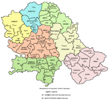
 Location within the City of Belgrade | ||
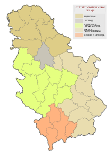
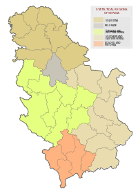
 Location within Serbia | ||
| Country | Serbia | |
| City | Belgrade | |
| Status | Municipality | |
| Settlements | 8 | |
| Government | ||
| • Type | Municipality of Belgrade | |
| • Mun. president | Aleksandar Jovičić (SNS) | |
| Area | ||
| • Total | 447 km2 (173 sq mi) | |
| Population (2011) | ||
| • Total | 170,593 | |
| • Density | 380/km2 (990/sq mi) | |
| Time zone | CET (UTC+1) | |
| • Summer (DST) | CEST (UTC+2) | |
| Postal code | 11000 | |
| Area code(s) | +381 11 | |
| Car plates | BG | |
| Website | www.palilula.org.rs | |
Palilula (Serbian Cyrillic: Палилула, pronounced [pǎlilula]) is an urban neighborhood and one of 17 municipalities which constitute the City of Belgrade, the capital of Serbia. It has the largest area of all municipalities of Belgrade. The core of Palilula is close to the center of the city, but the municipality also includes sparsely populated land left of the Danube.
Neighborhood
Location
Palilula is located east of Terazije in downtown Belgrade. Like most of Belgrade's neighborhoods it has no firm boundaries and is roughly bordered by the Ruzveltova street and the municipality and neighborhood of Zvezdara on the east, the neighborhood of Hadžipopovac in its own municipality on the north, the neighborhood and municipality of Stari Grad and Jevremovac on the northwest (Jevremovac actually belongs to the neighborhood of Palilula, but administratively is part of Stari Grad), and the Tašmajdan and King Alexander Boulevard on the south, bordering the municipality of Vračar. Several small local communities which make up this area had a combined population of 14,896 in 2002.
History
The neighborhood originated in the first half of the 18th century, when the Habsburg Monarchy occupied northern Serbia 1717–1739. The settlement, built as an outer suburb of Belgrade, was originally named Karlstadt and was known for agriculture and skilled crafts. In the early 19th century, it became overwhelmingly populated by the Serbs. In 1840, villagers of Palilula rejected the regulatory plan of Belgrade, on the basis that projected new streets would be too wide, and later even tried to split from the municipality of Belgrade because of the city government's low funding for the village. However, in the late 19th century Palilula became part of the continuously built-up area of Belgrade. The neighborhood was mostly residential, with commercial facilities closer to the center of Belgrade.
Name
The name Palilula comes from the expression pali lulu which in English means light a pipe. One anecdote goes back to times when Belgrade and Serbia were occupied by the Ottoman Empire and Palilula was the area where most crops were, so Turkish rulers banned smoking due to a few instances of accidentally setting crops on fire. In the late summer and early autumn when all the crops had been harvested, the smoking ban was lifted and locals announced this by calling neighbours, letting them know that pipes might be lit. Another explanation comes from the time of Prince Miloš Obrenović's rule; he banned smoking in Belgrade so people could only smoke outside the city gates.
Municipality
Area
The area of Palilula is generally the north of Belgrade. It is the northernmost of all Belgrade's municipalities and the easternmost of all urban municipalities. It is located on both banks of the Danube, which divides it in two: Šumadija section (on the right bank) and Banat section (on the left bank).
Šumadija section borders the municipalities of Stari Grad to the west, Vračar and Zvezdara to the south and Grocka to the extreme southeast. It also has a river border on the Danube to the province of Vojvodina (Municipality of Pančevo).
Banat section has no land borders to the other Belgrade municipalities, but has a river border on the Danube to the municipalities of Zemun and Stari Grad. The Danube also forms a complete western border to the rest of the Syrmia region in Vojvodina (municipality of Stara Pazova), while the river Tamiš is the eastern border (municipalities of Pančevo and Opovo). On the extreme north, Palilula borders the municipality of Zrenjanin (village of Čenta on the Karaš canal which connects the Danube and the Tamiš).
Geography
Šumadija section marks the northernmost point of Šumadija with Karaburma headland extending into the Danube. The prominent features in this part are the hills of Karaburma and Milićevo brdo, the spa of Višnjička Banja and the peninsula (formerly an island) Ada Huja.
Banat section is the extreme southwestern part of Banat region, known as Pančevački Rit. A 400 km2 (150 sq mi) large, flat, marshy floodplain of the Danube and Tamiš, it has been drained since 1945 but still has many features of a swamp, including slow, meandering and flooding streams (Vizelj, Mokri Sebeš, Jojkićev Dunavac, Dunavac, etc.) and marshy bogs (Sebeš, Veliko Blato, Široka Bara). An island of Kožara is located on the Danube, and is the projected starting point of the planned, much larger, artificial island of Čaplja. The spa of Ovčanska Banja is also located here. The area close to the Danube is heavily forested.
History and administration
The municipality was created in 1956. On January 3, 1957 the municipality of Karaburma was annexed to it, while in 1965 the municipality of Krnjača (with entire Pančevački Rit) also administratively joined Palilula.
Presidents of the Municipal Assembly:
- 1997–2000: Gordana Todić (b. 1955)
- 2000–October 21, 2004: Milan Marković (b. 1970)
- October 21, 2004–June 18, 2012: Danilo Bašić (b. 1973)
- June 18, 2012–June 6, 2016: Stojan Nikolić (b. 1976)
- June 6, 2016–present: Aleksandar Jovičić (b. 1976)
Dunavski Venac and Čenta
The idea of separating the area of former municipality of Krnjača start gaining momentum in the 2000s, this time under the name of Dunavski Venac. As procedure in the city statute provides that the municipal assembly (in this case, of Palilula) needs to start the motion in the city assembly, after years of public agitation, the municipal assembly of Palilula agreed to do so in summer 2005. However it did not officially do so, and the organization for the separation of Dunavski Venac announced it will go to court.
The village of Čenta in the Vojvodina's municipality of Zrenjanin is located on the northern border of the municipality of Palilula. From time to time local residents have asked for Čenta to be annexed to the City of Belgrade. The majority of the population work in the territory of Belgrade and until recently, one regular bus line of Belgrade City public transportation connected Čenta to Belgrade.
Population
With a population of 170,593 on December 31, 2011, according to the last census, Palilula is the third most populous municipality of Belgrade (after Novi Beograd and Čukarica), but the growth of population, as in the rest of Belgrade, is slowing. The fastest-growing population in the municipality is still the suburb of Borča. Population of Palilula:
- 1961 – 89,141
- 1971 – 126,380 (census)
- 1981 – 150,484 (census)
- 1991 – 150,208 (census)
- 2002 – 155,902 (census)
- 2011 – 170,593 (census)
Ethnic structure
According to the 2002 Census of population:
- Serbs = 135,586 (86.97%)
- Romani = 3,897 (2.50%)
- Yugoslavs = 2,279 (1.46%)
- Montenegrins = 1,858 (1.19%)
- Macedonians = 1,035 (0.66%)
- Croats = 931 (0.59%)
- Gorani = 836 (0.53%)
- Muslims = 823 (0.52%)
- Romanians = 781 (0.50%), mainly in Ovča
Neighborhoods and settlements


Neighborhoods of urban Palilula on the right bank of the Danube:
Neighborhoods of urban Palilula on the left bank of the Danube:
Settlements of suburban Palilula on the right bank of the Danube:
Settlements and neighborhoods of suburban Palilula on the left bank of the Danube:
Note: Borča and Ovča are classified as urban settlements (towns).
Neighborhoods of Borča:
Neighborhoods of Padinska Skela:
|
|
|
|
Economy
Industry and adjoining economic activities are located mostly along the right bank of the Danube. It includes the highly industrialized neighborhoods of Viline Vode (TEMPO cash-and-carry center, several gravel and sand extracting companies on the Danube's bank, Beograd railway, Centroprom, Martez, Tehnohemija, Jugopapir, Duga, the Avala cardboard factory, Balkan, the eastern part of the port of Belgrade and the railway station Beograd-Dunav) and Ada Huja (hangars and companies for building and construction, including a series of concrete plants and gravel and aggregates storing and treating facilities, paper and cardboard factory Avala-Ada, furniture factory Novi Dom, gravel storages of Tembo and DV Trade, etc.). It also includes a series of brickworks which occupy extensive areas of the northern ridge of the Field of Višnjica (Polet, Trudbenik, Jedinstvo, Kozara, Balkan, Rekord). There is also an extensive industrial zone in Krnjača and agricultural industry in Padinska Skela.
Palilula is crisscrossed by some of the major railroads in Belgrade area: Zrenjaninski put, Pančevački put, Višnjička street, Slanački put, etc. Belgrade's only bridge over the Danube, Pančevo Bridge (with railway) is located in Palilula.
Intensive agricultural production has developed in Banat section and eastern areas around Veliko Selo, producing large amounts of food (grains, fruits, vegetables, dairy products, etc.) for the population of Belgrade. Palilula has the largest agricultural area of all municipalities of Belgrade. It covers an area of 298 square kilometers, or 66,5% of the entire municipal territory.[1]
Culture, education and sports
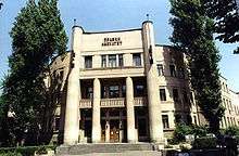
Urban Palilula hosts some of the most important faculties within Belgrade University: the Technical Faculty, the Faculty of Law and the Mining and Geology Faculty. Also, the building of Radio Television of Serbia, St. Mark's Church, Tašmajdan Park, Pionir Hall for sports, and the stadium of the OFK Belgrade soccer team are all located in the municipality.
Tourism
The spas of Višnjička Banja and Ovčanska Banja are not used or developed enough. Belgrade's largest kart racing track is located in Ada Huja. The future artificial island of Čaplja on the Danube is planned as a modern entertainment park, with aqua parks, golf courses, etc.
International cooperation
Palilula is twinned with following cities and municipalities:[2]
See also
References
External links
| Municipalities | ||
|---|---|---|
Coordinates: 44°48′42″N 20°30′58″E / 44.81167°N 20.51611°E
