Mount Adams (Colorado)
| Mount Adams | |
|---|---|
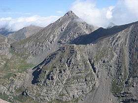 View of Mount Adams from the south | |
| Highest point | |
| Elevation | 13,937 ft (4,248 m) [1][2] |
| Prominence | 871 ft (265 m) [2] |
| Isolation | 1.86 mi (2.99 km) [2] |
| Coordinates | 38°00′27″N 105°36′17″W / 38.0074996°N 105.6047306°WCoordinates: 38°00′27″N 105°36′17″W / 38.0074996°N 105.6047306°W [3] |
| Geography | |
 Mount Adams | |
| Location | Custer and Saguache counties, Colorado, United States[3] |
| Parent range | Sangre de Cristo Range, Crestones[2] |
| Topo map |
USGS 7.5' topographic map Horn Peak, Colorado[3] |
| Climbing | |
| Easiest route | Scramble Class 3 |
Mount Adams is a high mountain summit of the Crestones in the Sangre de Cristo Range of the Rocky Mountains of North America. The 13,937-foot (4,248 m) thirteener is located in the Sangre de Cristo Wilderness, 5.1 miles (8.2 km) east by north (bearing 81°) of the Town of Crestone, Colorado, United States, on the drainage divide separating San Isabel National Forest and Custer County from Rio Grande National Forest and Saguache County.[1][2][3]
Climbing
Mount Adams can be climbed using Class 3 routes via the west ridge (Willow Lake), via the southeast face (Horn Creek Trailhead), or via the north west ridge (South Crestone Lake Trailhead).
See also
- List of Colorado mountain ranges
- List of Colorado mountain summits
- List of Colorado county high points
References
- 1 2 The elevation of Mount Adams includes an adjustment of +1.821 m (+5.97 ft) from NGVD 29 to NAVD 88.
- 1 2 3 4 5 "Mount Adams, Colorado". Peakbagger.com. Retrieved November 5, 2014.
- 1 2 3 4 "Mount Adams". Geographic Names Information System. United States Geological Survey. Retrieved November 5, 2014.
External links
This article is issued from Wikipedia - version of the 12/28/2015. The text is available under the Creative Commons Attribution/Share Alike but additional terms may apply for the media files.
