Metropolitan Borough of Lewisham
| Lewisham | |
|---|---|
 Lewisham within the County of London | |
| Area | |
| • 1911 | 7,014 acres (28 km2) |
| • 1931 | 7,015 acres (28 km2) |
| • 1961 | 7,016 acres (28 km2) |
| Population | |
| • 1911 | 160,834 |
| • 1931 | 219,953 |
| • 1961 | 221,753 |
| Density | |
| • 1911 | 23/acre |
| • 1931 | 31/acre |
| • 1961 | 32/acre |
| History | |
| • Created | 1900 |
| • Abolished | 1965 |
| • Succeeded by | London Borough of Lewisham |
| Status | Metropolitan borough |
| Government |
Lewisham Borough Council |
| • HQ | Town Hall, Catford |
| • Motto |
Salus Populi Suprema Lex (The welfare of the people is the highest law) |
 Coat of arms of the borough council | |
The Metropolitan Borough of Lewisham was a Metropolitan borough in the County of London between 1900 and 1965, when it became part of the London Borough of Lewisham along with the Metropolitan Borough of Deptford.
History
The borough was formed by the London Government Act 1899 from the civil parishes of Lee from the Lee District and Lewisham from the Lewisham District. The borough also took in a small area formerly administered by Camberwell Vestry on the western slopes of Forest Hill.[1]
While there had been minor industry along the River Ravensbourne for centuries and the extension of the railways had seen suburban development, there were still large areas of farmland at the time of the borough's formation. The next London property boom in the 1930s saw much of that farmland built upon with both private estates, and the final gaps on the roads to Kent were filled in later on with London County Council built social housing, particularly in Downham and Bellingham.
Geography
The borough bordered Deptford, Greenwich, Camberwell, and had a portion of the southern boundary of the county of London.
Places in it included Lewisham, Blackheath, Lee, Hither Green, Catford, Brockley, Forest Hill and part of Sydenham.
Population and area
The area of the borough was 7,015 acres (28.4 km2). The population, as recorded at the census, was:
Constituent parishes 1801–1899
| Year[2] | 1801 | 1811 | 1821 | 1831 | 1841 | 1851 | 1861 | 1871 | 1881 | 1891 |
|---|---|---|---|---|---|---|---|---|---|---|
| Population | 4,383 | 7,137 | 8,922 | 10,767 | 14,636 | 18,616 | 28,970 | 47,018 | 67,500 | 88,653 |
Metropolitan Borough 1900–1961
| Year[3] | 1901 | 1911 | 1921 | 1931 | 1941 | 1951 | 1961 |
|---|---|---|---|---|---|---|---|
| Population | 127,495 | 160,834 | 174,194 | 219,953 | [4] | 227,576 | 221,753 |
Coat of arms
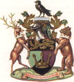
When the borough was created in 1900, a committee was appointed to design a coat of arms. This device, adopted in the following year, included a shield, crest, supporters and motto.[5]
The shield had four quarters. The first quarter had the attributed arms of King Alfred, first lord of the manor. The second quarter showed a white on red horse, the arms associated with Kent. The Lewisham area was part of Kent until 1889. The third quarter showed a buck's head, from the arms of the Earl of Dartmouth, lord of the manor of Lewisham in 1901. The fourth quarter featured a bear's head and fesse or horizontal band, from the arms of Lord Northbrook, lord of the manor of Lee in 1901.
The crest was a raven, representing the Ravensbourne river.
The supporters were a silver buck sprinkled with red stars and a bear with a gold portcullis on his shoulder. These were also derived from the arms of the Earl of Dartmouth and Lord Northbrook respectively.
The Latin motto was Salus Populi Suprema Lex, or "the welfare of the people is the highest law" - a motto common to many English municipalities.
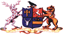
In 1950, in celebration of the borough's golden jubilee, a grant of arms was obtained from the College of Arms.[6]
The shield was greatly simplified: A Saxon crown and golden lion recalled the association of King Alfred with the area. The background of three colours recalled the three main areas of the borough: green for Lee Green, purple for Hither (or heather) Green and black for Blackheath.
The raven crest was retained, with the addition of a silver and blue wave for the Ravensbourne.
The 1901 supporters were altered to make them unique to the borough. Around their necks were placed mural crowns, representative of local government.
The motto was not changed, and was continued in use by the London Borough of Lewisham in 1965.
Politics

The borough was divided into ten wards for elections: Blackheath, Brockley, Catford, Church, Forest Hill, Lewisham Park, Lewisham Village, Manor, South and Sydenham.[7][8]
Parliament constituency
For elections to Parliament, the borough was represented by one constituency:
In 1918 the borough's representation was increased to two seats:
In 1950 the borough's representation was increased to three seats:
References
- ↑ Frederic A Youngs Jr., Guide to the local administrative units of England, Vol. I: Southern England, London 1979
- ↑ Statistical Abstract for London, 1901 (Vol. IV); Census tables for Metropolitan Borough of Deptford
- ↑ Census Tables for Metropolitan Borough of Lewisham, from Vision of Britain website accessed 16 Jun 2007
- ↑ The census was suspended for World War II
- ↑ London's Coats of Arms, Richard Crosley, 1928
- ↑ London 1900 - 1964, Armorial bearings and regalia of the London County Council, the Corporation of London and the Metropolitan Boroughs, J. F. Beningfield, 1964
- ↑ Post Office London County Suburbs Directory, 1919. 1919. Retrieved 18 February 2015.
- ↑ Ordnance Survey 'County Series 3rd Edition' Map of London (1912-14) at 1:2500 scale. Accessed at https://www.old-maps.co.uk/
Further reading
- Robert Donald, ed. (1907). "London: Lewisham". Municipal Year Book of the United Kingdom for 1907. London: Edward Lloyd.
Local government districts abolished or transferred by the London Government Act 1963 | ||
|---|---|---|
| London | ||
| Essex | ||
| Hertfordshire | ||
| Middlesex, CC | ||
| Kent | ||
| Surrey | ||
| Transfers | Middlesex to Hertfordshire: Potters Bar
| |
Coordinates: 51°26′43″N 0°01′15″W / 51.4452°N 0.0208°W
