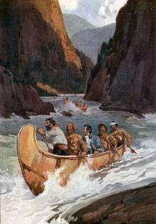
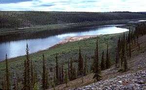
List of longest rivers of Canada
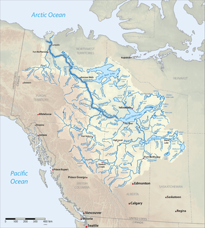
Among the longest rivers of Canada are 47 streams of at least 600 km (370 mi). In the case of some rivers such as the Columbia, the length listed in the table below is solely that of the main stem. In the case of others such as the Mackenzie, it is the combined lengths of the main stem and one or more upstream tributaries, as noted. Excluded from the list are rivers such as the Dauphin, a short connecting link between lakes Manitoba and Winnipeg, with main stems of 100 km (62 mi) or less. Also excluded are rivers such as the Mississippi, the main stems of which do not enter Canada even though some of their tributaries do.
Nine rivers in this list cross international boundaries or form them. Four—the Yukon, Columbia, Porcupine, and Kootenay—begin in Canada and flow into the United States. Five—the Milk, Pend d'Oreille, Saint Lawrence, Red, and Saint John—begin in the United States and flow into Canada. Of these, the Milk and the Kootenay cross the international border twice, the Milk leaving and then re-entering the United States, the Kootenay leaving and then re-entering Canada.[1] The drainage basins of these nine rivers extend into both countries; in addition, the drainage basins of six others—the Fraser, Assiniboine, South Saskatchewan, Saskatchewan, Nelson, and Winnipeg—extend into the United States even though their main stems flow entirely within Canada.
Sources report hydrological quantities with varied precision. Biologist and author Ruth Patrick, describing a table of high-discharge rivers, wrote that data on discharge, drainage area, and length varied widely among authors whose works she consulted. "It seems," she said, "that the wisest course is to regard data tables such as the present one as showing the general ranks of rivers, and not to place too much importance on minor (10–20%) differences in figures."[2]
Table
The primary source for data in the table below is The Atlas of Canada; other sources are as noted. Discharge refers to the flow at the mouth except as noted. U.S. states appear in italics. Abbreviations are as follows: "km" for "kilometre", "mi" for "mile", "s" for "second", "m" for "metre", and "ft" for "foot".
| Key | |||||
|---|---|---|---|---|---|


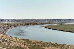

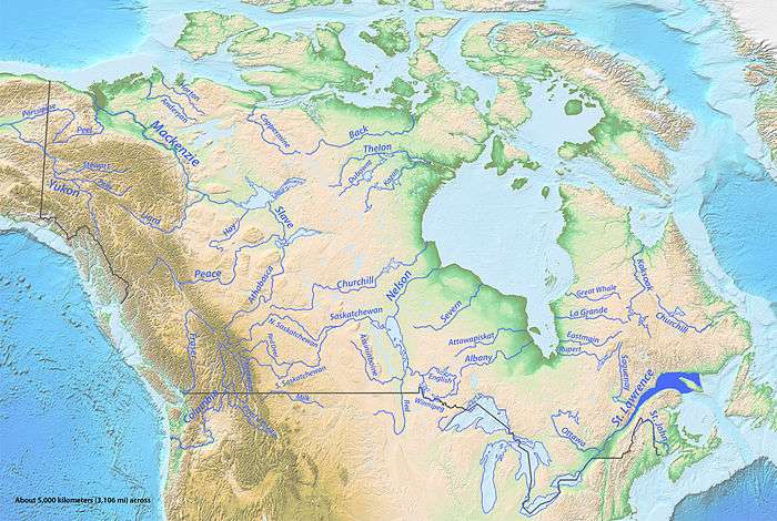
Map
See also
Notes and references
- Notes
- ↑ Except as noted, source coordinates were derived via a topographic map search engine embedded in The Atlas of Canada.[4]
- ↑ To the head of the Finlay River.[7]
- ↑ To the head of the Nisutlin River. Of the total length of 3,185 km (1,979 mi), 1,149 km (714 mi) (about 36 percent) are in Canada.[7]
- ↑ Split between 323,800 km2 (125,000 mi2), about 39 percent, in Canada and 515,400 km2 (199,000 mi2), about 61 percent, in the United States.[7]
- ↑ To the head of the Saint Louis River in Minnesota.[7]
- ↑ Split between 839,200 km2 (324,000 mi2) (about 62 percent) in Canada and 505,000 km2 (195,000 mi2) (about 38 percent) in the United States.[7]
- ↑ To the head of the Bow River.[7]
- ↑ Split between 690,900 square kilometres (266,800 sq mi), about 77 percent, in Canada and 201,400 square kilometres (77,800 sq mi), about 23 percent, in the United States. The totals for the two countries were derived by adding the U.S. watershed subtotals for the Assiniboine, Red, Winnipeg, and Saskatchewan rivers, which feed into the Nelson.[7]
- ↑ Derived by adding the length of the Peace River (measured from its mouth to the headwaters of the Finlay River) to the length of the main stem of the Slave River.[7]
- ↑ About 801 km (498 mi), 40 percent of the total, are in Canada.[7]
- ↑ Split between 102,800 km2 (39,700 mi2) (about 15 percent) in Canada and 568,500 km2 (219,500 mi2) (about 85 percent) in the United States.[7]
- ↑ To the head of the Bow River.[7]
- ↑ Split between 334,100 km2 (129,000 sq mi) (about 99.5 percent) in Canada and 1,800 km2 (690 sq mi) (about 0.5 percent) in the United States.[7]
- ↑ To the head of the Finlay River.[7]
- ↑ To the head of Churchill Lake.[7]
- ↑ To the head of the Bow River.[7]
- ↑ Split between 144,300 km2 (55,700 sq mi) (about 99 percent) in Canada and 1,800 km2 (690 sq mi) (about 1 percent) in the United States.[7]
- ↑ Split between 232,300 km2 (89,700 sq mi) (about 99.7 percent) in Canada and 800 km2 (310 sq mi) (about 0.3 percent) in the United States.[7]
- ↑ Rivers of North America lists a basin size of 154,880 square kilometres (59,800 sq mi), but this includes Lake Athabasca, the Peace–Athabasca Delta, and the basins of the Fond du Lac River and some of the other streams flowing into the lake.[26]
- ↑ Split between 160,600 km2 (62,000 mi2) (about 88 percent) in Canada and 21,400 km2 (8,300 mi2) (about 12 percent) in the United States.[7]
- ↑ According to the Milk River Watershed Council, a 180-km (110 mi) stretch of the river flows through Canada. This amounts to about 18 percent of the river's total length.[32]
- ↑ Split between 21,600 km2 (8,300 mi2) (about 35 percent) in Canada and 39,600 km2 (15,300 mi2) (about 65 percent) in the United States.[7]
- ↑ To the head of the Cat River.[7]
- ↑ Based on data from the years 1968–69, 73, and 75–84 at Hat Island,[35] about 200 kilometres (120 mi) from the mouth. Distance from mouth estimated with a measurement tool embedded in The Atlas of Canada topographic maps.[4]
- ↑ To the head of the Black Birch River.[7]
- ↑ Based on data from the years 1973–74, 77–79, and 83–84 at Limestone Rapids,[37] about 40 kilometres (25 mi) from the mouth.[38]
- ↑ To the head of Muskox Lake.[7]
- ↑ Split between 255 kilometres (158 mi) or about 29 percent in Canada and 635 kilometres (395 mi) or about 71 percent in the United States.[44]
- ↑ Split between 138,600 km2 (53,500 sq mi) (about 48 percent) in Canada and 148,900 km2 (57,500 sq mi) (about 52 percent) in the United States.[7]
- ↑ To the head of the Caniapiscau River.[7]
- ↑ To the head of the Ashuanipi River.[7]
- ↑ This is the mean discharge for a point about 100 kilometres (62 mi) from the mouth rather than at the mouth.[50]
- ↑ Measured by a gauge at the outlet of Marjorie Lake, about 50 kilometres (31 mi) from the mouth. Flow derived by converting km3/yr to m3/s.[52] Distance from mouth estimated with a measurement tool embedded in The Atlas of Canada topographic maps.[4]
- ↑ To the head of the Firesteel River.[7]
- ↑ Split between 106,500 square kilometres (41,100 sq mi) in Canada, about 78 percent, and 29,300 square kilometres (11,300 sq mi), about 22 percent, in the United States.[7]
- ↑ Split between 37,700 square kilometres (14,600 sq mi), about 52 percent, in Canada and 12,600 square kilometres (4,900 sq mi), about 48 percent, in the United States.
- ↑ To the head of the Megiscane River.[7]
- ↑ To the head of the Temiscamie River.[7]
- ↑ To the head of Attawapiskat Lake.[7]
- ↑ Based on data from the years 1967–80 and 82–84 at the source, Attawpiskat Lake, rather than at the mouth.[59]
- ↑ To the head of Ennadai Lake.[7]
- ↑ Split between 61,400 square kilometres (23,700 sq mi) in Canada, about 52 percent, and 56,500 square kilometres (21,800 sq mi), about 48 percent, in the United States.[7]
- ↑ To the head of the Silver Bow Creek. Length derived by adding the distance from the mouth to the head of Pend Oreille Lake, shown on topo maps as about 220 kilometres (140 mi)[65] to the length (about 480 kilometres (300 mi) of the Clark Fork River and its headwater tributary, Silver Bow Creek.[66] Of this total, only 22 km (14 mi), about 3 percent, are in Canada.[67]
- ↑ Split between 1,600 square kilometres (620 sq mi) in Canada, about 2 percent, and 65,000 square kilometres (25,000 sq mi), about 98 percent, in the United States.[67]
- ↑ To the head of the Peribonka River.[7]
- ↑ Measured by a gauge below the Carnwath River, about 150 kilometres (93 mi) from the Anderson River mouth. Flow derived by converting km3/yr to m3/s.[52] Distance from mouth estimated with a measurement tool embedded in The Atlas of Canada topographic maps.[4]
- ↑ To the head of the Ogilvie River.[7]
- ↑ Split between 35,000 square kilometres (14,000 sq mi) (about 63 percent) in Canada and 19,700 square kilometres (7,600 sq mi) (about 37 percent) in the United States.[7]
- References
- ↑ The Road Atlas. Chicago, Illinois: Rand McNally & Company. 2008. ISBN 0-528-93961-0.
- ↑ Patrick, Ruth (1995). Rivers of the United States: Volume II: Chemical and Physical Characteristics. New York: John Wiley & Sons. p. 24. ISBN 0-471-10752-2.
- 1 2 3 From The Atlas of Canada unless otherwise noted
- 1 2 3 4 "The Atlas of Canada, Advanced Search". Natural Resources Canada. Retrieved May 18, 2011.
- ↑ Measured at the mouth unless otherwise noted
- ↑ "Mackenzie River, Northwest Territories". The Atlas of Canada. Natural Resources Canada. Retrieved May 18, 2011.
- 1 2 3 4 5 6 7 8 9 10 11 12 13 14 15 16 17 18 19 20 21 22 23 24 25 26 27 28 29 30 31 32 33 34 35 "Rivers". The Atlas of Canada. Natural Resources Canada. Retrieved May 15, 2011.
- 1 2 "Yukon River". Geographic Names Information System. United States Geological Survey. March 31, 1981. Retrieved February 4, 2011.
- ↑ Benke and Cushing, p. 796
- ↑ "Saint Lawrence River". The Atlas of Canada. Natural Resources Canada. Retrieved February 3, 2011.
- ↑ "Saint Louis River". Geographic Names Information System. United States Geological Survey (USGS). January 11, 1980. Retrieved May 19, 2011.
- ↑ "Nelson River, Manitoba". The Atlas of Canada. Natural Resources Canada. Retrieved May 16, 2011.
- ↑ "Slave River, Northwest Territories". The Atlas of Canada. Natural Resources Canada. Retrieved May 30, 2011.
- ↑ Benke and Cushing, p. 843
- ↑ "Columbia River". Geographic Names Information System. United States Geological Survey. November 28, 1980. Retrieved August 5, 2010.
- ↑ Benke and Cushing, p. 646
- ↑ "Saskatchewan River, Manitoba". The Atlas of Canada. Natural Resources Canada. Retrieved May 16, 2011.
- ↑ "Peace River, Alberta". The Atlas of Canada. Natural Resources Canada. Retrieved May 16, 2011.
- ↑ Benke and Cushing, p. 844
- ↑ "Churchill River, Manitoba". The Atlas of Canada. Natural Resources Canada. Retrieved May 8, 2011.
- ↑ "South Saskatchewan River, Saskatchewan". The Atlas of Canada. Natural Resources Canada. Retrieved May 7, 2011.
- ↑ "Fraser River, British Columbia". The Atlas of Canada. Natural Resources Canada. Retrieved May 25, 2011.
- ↑ "North Saskatchewan River, Saskatchewan". The Atlas of Canada. Natural Resources Canada. Retrieved May 16, 2011.
- ↑ "Ottawa River, Ontario". Natural Resources Canada. Retrieved May 16, 2011.
- ↑ "Athabasca River, Alberta". The Atlas of Canada. Natural Resources Canada. Retrieved May 16, 2011.
- 1 2 Benke and Cushing, p. 845
- ↑ "Liard River, Northwest Territories". The Atlas of Canada. Natural Resources Canada. Retrieved May 12, 2011.
- ↑ Benke and Cushing, p. 815
- ↑ Benke and Cushing, p. 842
- ↑ "Assiniboine River, Manitoba". The Atlas of Canada. Natural Resources Canada.
- 1 2 "Milk River". Geographic Names Information System. United States Geological Survey (USGS). April 4, 1980. Retrieved February 5, 2011.
- ↑ "Milk River State of the Watershed Report, Part 3" (PDF). Milk River Watershed Council. 2008. Retrieved February 19, 2011.
- ↑ Benke and Cushing, p. 475
- ↑ "Albany River, Ontario". The Atlas of Canada. Natural Resources Canada. Retrieved May 16, 2011.
- ↑ SAGE: Center for Sustainability and the Global Environment (February 13, 2010). "Severn". River Discharge Database. University of Wisconsin. Retrieved May 23, 2011.
- ↑ "Severn River, Ontario". The Atlas of Canada. Natural Resources Canada. Retrieved May 22, 2011.
- ↑ SAGE: Center for Sustainability and the Global Environment (February 13, 2010). "Severn". River Discharge Database. University of Wisconsin. Retrieved May 23, 2011.
- ↑ Dymond, J.R.; Scott, W.B. (November 21, 1941). "Fishes of the Patricia Portion of the Kenora District, Ontario". Copeia. American Society of Ichthyologists and Herpetologists. 1941 (4): 243. doi:10.2307/1437471.
- ↑ "Back River, Nunavut". The Atlas of Canada. Natural Resources Canada. Retrieved May 4, 2011.
- ↑ Marsh, James. "Back River". The Canadian Encyclopedia. Historica Dominion Institute. Retrieved May 3, 2011.
- ↑ "Thelon River, Nunavut". The Atlas of Canada. Natural Resources Canada. Retrieved May 5, 2011.
- ↑ "La Grande Rivière" (in French). Gouvernement du Québec. Retrieved May 16, 2011.
- ↑ "Red River". The Atlas of Canada. Natural Resources Canada. Retrieved January 17, 2011.
- ↑ "Red River of the North: A Water Trail Guide" (PDF). Minnesota Department of Natural Resources. 2010. Retrieved May 29, 2011.
- ↑ "Red River of the North". Geographic Names Information System. United States Geological Survey (USGS). January 1, 2000. Retrieved May 29, 2011.
- ↑ Benke and Cushing, p. 896
- ↑ "Rivière Koksoak" (in French). Gouvernement du Québec. Retrieved May 16, 2011.
- ↑ "Churchill River, Newfoundland and Labrador". The Atlas of Canada. Natural Resources Canada. Retrieved May 13, 2011.
- ↑ "Coppermine River, Nunavut". The Atlas of Canada. Natural Resources Canada. Retrieved May 25, 2011.
- 1 2 "Coppermine River: Overview of the Hydrology and Water Quality" (PDF). Indian and Northern Affairs Canada. July 13, 2010. pp. 1–5. Retrieved May 3, 2011.
- ↑ "Dubawnt River, Nunavut". The Atlas of Canada. Natural Resources Canada. Retrieved May 22, 2011.
- 1 2 "List of Arctic RIMS Discharge Stations". University of New Hampshire. Retrieved May 22, 2011.
- ↑ "Winnipeg River, Manitoba". The Atlas of Canada. Natural Resources Canada. Retrieved May 15, 2011.
- ↑ Benke and Cushing, p. 898
- ↑ "Kootenay River, British Columbia". The Atlas of Canada. Natural Resources Canada. Retrieved May 19, 2011.
- ↑ "Rivière Rupert". The Atlas of Canada. Natural Resources Canada. Retrieved May 26, 2011.
- ↑ "Rivière Eastmain". The Atlas of Canada. Natural Resources Canada. Retrieved May 26, 2011.
- ↑ "Attawapiskat River, Ontario". The Atlas of Canada. Natural Resources Canada.
- ↑ SAGE: Center for Sustainability and the Global Environment (February 13, 2010). "Attawapiskat". River Discharge Database. University of Wisconsin. Retrieved May 23, 2011.
- ↑ "Kazan River, Nunavut". The Atlas of Canada. Natural Resources Canada.
- ↑ "Red Deer River, Alberta". The Atlas of Canada. Natural Resources Canada. Retrieved May 27, 2011.
- ↑ "Grande rivière de la Baleine, Quebec". The Atlas of Canada. Natural Resources Canada. Retrieved May 27, 2011.
- ↑ Benke and Cushing, p. 802
- ↑ "Pend-d'Oreille River, British Columbia". The Atlas of Canada. Natural Resources Canada. Retrieved June 6, 2011.
- ↑ United States Geological Survey. "Hope, Idaho, quadrangle". TopoQuest. Retrieved June 6, 2011.
- ↑ Merriam Webster's Geographical Dictionary (3rd ed.). Springfield, Massachusetts: Merriam-Webster, Inc. 1998. p. 258. ISBN 0-87779-546-0.
- 1 2 Swain, L.G. (August 2007). "Canada–British Columbia Water Quality Monitoring Agreement: Water Quality Assessment of Pend d'Oreille River at Waneta (1980–2006)" (PDF). British Columbia Ministry of Environment. p. 1. Retrieved June 6, 2011.
- ↑ "Silver Bow Creek". Geographic Names Information System. United States Geological Survey. April 4, 1980. Retrieved June 6, 2011.
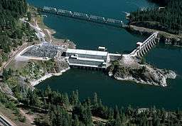
- ↑ "Waneta Hydroelectric Expansion Project EAC Application" (PDF). Government of British Columbia. May 2006. p. 12. Retrieved June 8, 2011.
- ↑ "Hay River, Northwest Territories". The Atlas of Canada. Natural Resources Canada. Retrieved May 29, 2011.
- ↑ Benke and Cushing, p. 848
- ↑ "Saguenay River, Quebec". The Atlas of Canada. Natural Resources Canada. Retrieved May 23, 2011.
- ↑ "Anderson River, Northwest Territories". The Atlas of Canada. Natural Resources Canada. Retrieved May 22, 2011.
- ↑ "Peel River, Northwest Territories". The Atlas of Canada. Natural Resources Canada. Retrieved May 19, 2011.
- ↑ Benke and Cushing, p. 850
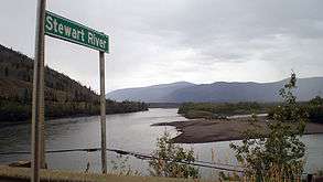
- ↑ "Stewart River, Yukon". The Atlas of Canada. Natural Resources Canada. Retrieved May 25, 2011.
- ↑ Benke and Cushing, p. 800
- ↑ "Horton River, Northwest Territories". The Atlas of Canada. Natural Resources Canada. Retrieved May 22, 2011.
- ↑ Giberson, Donna J.; Shaverdo, Helena V. (Fall 2003). "Update on the survey of aquatic insects from Keewatin and Mackenzie project: The predaceous water beetles (Coleoptera: Adephaga: Dytiscidae and Gyrinidae)". Newsletter of the Biological Survey of Canada (Terrestrial Arthropods). University of Alberta. 22 (2). Retrieved May 27, 2011.
- ↑ "English River, Ontario". The Atlas of Canada. Natural Resources Canada. Retrieved May 22, 2011.
- ↑ "Pelly River, Yukon". The Atlas of Canada. Natural Resources Canada. April 2, 2004. Retrieved May 18, 2011.
Works cited
- Benke, Arthur C., ed., and Cushing, Colbert E., ed. Rivers of North America. Burlington, Massachusetts: Elsevier Academic Press. ISBN 0-12-088253-1.