Winnipeg River
| Winnipeg River | |
| Country | Canada |
|---|---|
| Provinces | Ontario, Manitoba |
| Source | Lake of the Woods |
| - location | Kenora District, Ontario |
| - elevation | 322 m (1,056 ft) |
| - coordinates | 49°46′18″N 94°31′27″W / 49.77167°N 94.52417°W |
| Mouth | Lake Winnipeg |
| - location | Manitoba |
| - elevation | 217 m (712 ft) |
| - coordinates | 50°37′54″N 96°19′13″W / 50.63167°N 96.32028°WCoordinates: 50°37′54″N 96°19′13″W / 50.63167°N 96.32028°W [1] |
| Length | 235 km (146 mi) |
| Basin | 106,500 km2 (41,100 sq mi) [2] |
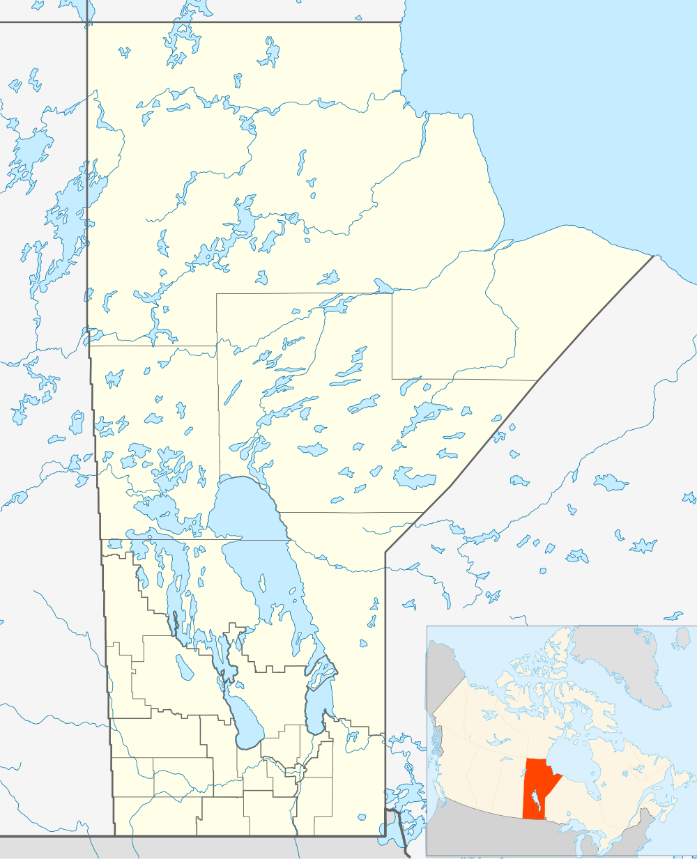 Location of the mouth of the river in Manitoba; Lake of the Woods is the large lake at the bottom right of the main map | |
 Map of Lake of the Woods showing the Winnipeg River leaving at the northwest | |
The Winnipeg River is a Canadian river which flows from Lake of the Woods in the province of Ontario to Lake Winnipeg in Manitoba. This river is 235 kilometres (146 mi) long from the Norman Dam in Kenora to its mouth at Lake Winnipeg. Its watershed is 106,500 square kilometres (41,100 sq mi) in area, mainly in Canada. About 29,000 square kilometres (11,000 sq mi) of this area is in northern Minnesota.[2]
The watershed stretches to the height of land about 100 kilometres (62 mi) west of Lake Superior. The Winnipeg River watershed was the southeastern-most portion of the land granted to the Hudson's Bay Company in 1670. The portion in Canada corresponds roughly to the land deeded to Canada in Treaty 3, signed by Her Majesty's treaty commissioners and the First Nation chiefs at Northwest Angle on the Lake of the Woods in 1873. The river's name means "murky water" in Cree.
This river route was used by natives for thousands of years and became a major fur trade route for hundreds of years. It is the only major water route between what is now southern Manitoba and Ontario that allowed natives to easily canoe back and forth. The Red River route was much farther south and with a longer portage. La Vérendrye was one of the first explorers to establish fur trade forts near the native camps in the area. The Winnipeg River system through Whiteshell Provincial Park has many petroforms near the Whiteshell River forks where the two rivers meet. These petroforms are an ancient reminder of the importance of the area for native travel, trade, ceremonies, harvesting, and settlements.
Major modern communities along the banks of the Winnipeg River include: Lac du Bonnet, Pinawa, Powerview, and Pine Falls, all in Manitoba, and Kenora, Minaki and Whitedog in Ontario. Whitedog is the home of the Wabaseemoong First Nation.
In Manitoba, the Winnipeg River is broken up by six hydroelectric dams: the Pointe du Bois Generating Station at Pointe du Bois, Slave Falls just a few kilometres downstream, Seven Sisters Falls Generating Station at Seven Sisters, MacArthur Falls Generating Station, the Great Falls Generating Station, and the Pine Falls Generating Station at Powerview, Manitoba. In Ontario there are dams at Kenora and Whitedog Falls.
There are also many lakes along the Winnipeg River where the river widens, including Nutimik, Eleanor, Dorothy, Margaret, Natalie, and Lac du Bonnet, all in Manitoba. Nutimik, Dorothy, and Margaret Lakes are all entirely within the Whiteshell Provincial Park. Lakes in the Ontario portion of the river include Gun, Roughrock and Sand.
Tributaries include the: Rainy River, Black Sturgeon River, English River, Bird River, Lee River, Whiteshell River, Whitemouth River, and the Macfarlane River.
Flows on the Winnipeg River are controlled by the Lake of the Woods Control Board which maintains a website[3] with detailed descriptions of the river basin and water flow characteristics.
Tributaries
- Black Sturgeon River
- Macfarlane River
- English River
- Bird River
- Maskwa River
- Lee River
- Dean Creek
- Tie Creek
- Whiteshell River
- Whitemouth River
Lakes
- Lake of the Woods (source)
- Middle Lake
- Gun Lake
- Pistol Lake
- Little Sand Lake
- Big Sand Lake
- Roughrock Lake
- Swan Lake
- Tetu Lake
- Numao Lake
- Nutimik Lake
- Dorothy Lake
- Margaret Lake
- Sylvia Lake
- Natalie Lake
- Eleanor
- Lac du Bonnet
- Lake Winnipeg (mouth)
Exploration and fur trade
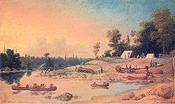
The Winnipeg River was the main route from the Great Lakes to Western Canada before the coming of railroads. Once on Lake Winnipeg one could go by canoe as far as the Rocky Mountains, Arctic Ocean or Hudson Bay. This section covers the route from Lake Superior to Lake Winnipeg via Rainy Lake, Rainy River, Lake of the Woods and the Winnipeg River. For the route in general see Canadian canoe routes (early)#Nelson River basin.
The area was too rocky to be good beaver country. Grand Portage was the second longest portage in Canada after Methye Portage. Once over the height of land rivers led west to Rainy Lake and Rainy River. Duncan M'Gillivray called the Rainy the 'most beautiful river in the north'. George Simpson (administrator) and many others made similar comments. The route then went up the east side of Lake of the Woods and over the Rat Portage (Kenora) to the Winnipeg. The Winnipeg was notorious for its many portages and décharges. Three were the Dales, Portage de l'Isle and La Rivière Blanche named for its white water. This last was the scene of many deaths and had seven portages all visible from the same spot. After the last portage, apparently Manitou Rapids, the river opened out into the Bas de la Rivière and then the lake. About halfway up the river, the English River (Ontario) led to Fort Albany, Ontario on James Bay.
In 1679 Daniel Greysolon, Sieur du Lhut reached the western tip of Lake Superior. In 1688 Jacques de Noyon went from Kaministiquia as far as Rainy Lake and perhaps beyond. He seems to have been followed by coureurs des bois who may have gotten as far as Lake Winnipeg. They left no records but the English on Hudson Bay heard reports of them in 1718 if not earlier.[4] In 1717 Zacharie Robutel de La Noue tried and failed to penetrate the area. The land west of Lake Superior was opened by La Vérendrye in 1731–1743. In 1731 his men built a post on Rainy Lake. In 1732 he built Fort Saint Charles on Lake of the Woods. In 1733 one of his sons got almost to Lake Winnipeg but was blocked by ice. In 1734 two explorers reported that they had reached the south end of Lake Winnipeg and the first Fort Maurepas (Canada) was built there soon after. By 1743 the French had reached the Assiniboine River and Saskatchewan Rivers and had sent explorers to North Dakota and, probably, Wyoming.
All this drew trade away from the Hudson's Bay Company. After the conquest of Canada the French were replaced by "Pedlars" (as the HBC people called them) from Montreal. The pedlars soon formed the North West Company. From about 1775 the HBC began building competing posts in the interior, including one on Rainy River. Competition ended in 1821 when the two companies merged and trade was diverted to York Factory on Hudson Bay. Trade was also diverted south as population grew on the US side. The last major use of the route was by the Wolseley Expedition in 1870. After 1885 the Canadian Pacific Railway connected eastern and western Canada with a route north of Lake Superior.
Trading posts on the route were:
- Lake Superior: 1.Fort Kaministiquia (1717), later called Fort William, Ontario (NWC, 1803) and 2. Grand Portage with Fort Charlotte;
- Rainy River: Fort Saint Pierre (1731), Fort Lac la Pluie (NWC, circa 1780), Asp House (HBC 1794), Hungry Hall (HBC 1825);
- Lake of the Woods: Fort Saint Charles (1732);
- Winnipeg River Mouth:Fort Maurepas (Canada) (c 1739), Fort Bas de la Rivière (NWC, 1792), Fort Alexander (HBC, before 1800)
See also
References
- Morton, Arthur Silver (1973). Thomas, Lewis Gwynne, ed. A history of the Canadian west to 1870–71; being a history of Rupert's Land (the Hudson's Bay Company's territory) and of the North-West Territory (including the Pacific slope) (2nd ed.). Toronto: University of Toronto Press in co-operation with the University of Saskatchewan. ISBN 9780802040336. OCLC 666891.
- ↑ "Winnipeg River". Geographical Names Data Base. Natural Resources Canada. Retrieved 2010-11-24.
- 1 2 "Canada Drainage Basins". The National Atlas of Canada, 5th edition. Natural Resources Canada. 1985. Retrieved 24 November 2010.
- ↑ Lake of the Woods Control Board
- ↑ Morton, page 160
| Wikimedia Commons has media related to Winnipeg River. |