List of hillside letters

Distribution of hillside letters in the Western United States
Main article: Hillside letters

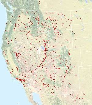
This is a list of hillside letters (also known as mountain monograms), large geoglyphs found primarily in the Western United States.[1][2][3] There are well over 500 in total, but the status of many of these symbols are uncertain, due to vagueness in sources.

The states with the most hillside letters are:

This list is incomplete; you can help by expanding it.

United States

Arizona

California

Colorado

At least 25 monograms, possibly 28

Monogram Town State Description Coordinates
A Fort Collins Colorado Colorado State University (formerly the Aggies) 40°33′40″N 105°09′04″W / 40.561°N 105.151°W / 40.561; -105.151 (Colorado State University)
B Branson Colorado 37°00′33″N 103°52′53″W / 37.0092°N 103.8815°W / 37.0092; -103.8815 (Branson)
C Cañon City Colorado 38°26′35″N 105°15′00″W / 38.443°N 105.25°W / 38.443; -105.25 (Cañon City)
D Del Norte Colorado 37°40′19″N 106°21′32″W / 37.6719°N 106.3588°W / 37.6719; -106.3588 (Del Norte)
D Dinosaur Colorado 40°14′47″N 109°00′23″W / 40.2463°N 109.0064°W / 40.2463; -109.0064 (Dinosaur)
G Golden Colorado 39°45′08″N 105°12′24″W / 39.7521°N 105.2066°W / 39.7521; -105.2066 (Golden)
GV Parachute Colorado Grand Valley High School 39°27′40″N 108°03′15″W / 39.461°N 108.0542°W / 39.461; -108.0542 (Grand Valley High School)
GM (uncertain existence) Lakewood Colorado Green Mountain High School 39°41′59″N 105°09′32″W / 39.6997°N 105.159°W / 39.6997; -105.159 (Green Mountain High School) (uncertain location)
G Gunnison Colorado 38°33′04″N 106°54′52″W / 38.551°N 106.9144°W / 38.551; -106.9144 (Gunnison)
H Hotchkiss Colorado 38°47′32″N 107°42′03″W / 38.7923°N 107.7008°W / 38.7923; -107.7008 (Hotchkiss)
LV La Veta Colorado 37°31′21″N 105°00′25″W / 37.5224°N 105.007°W / 37.5224; -105.007 (La Veta)
LHS Sopris Colorado Lincoln High School 37°07′51″N 104°34′21″W / 37.1308°N 104.5724°W / 37.1308; -104.5724 (Sopris)
L Loma Colorado 39°11′22″N 108°50′35″W / 39.1894°N 108.843°W / 39.1894; -108.843 (Loma)
L Lyons Colorado 40°12′34″N 105°15′56″W / 40.2095°N 105.2656°W / 40.2095; -105.2656 (Lyons)
M Golden Colorado Colorado School of Mines 39°44′43″N 105°14′24″W / 39.7453°N 105.24°W / 39.7453; -105.24 (Colorado School of Mines)
M Manassa Colorado 37°09′23″N 105°55′56″W / 37.1564°N 105.9323°W / 37.1564; -105.9323 (Manassa)
P (uncertain existence) Pagosa Springs Colorado 37°16′04″N 107°00′36″W / 37.2677°N 107.01°W / 37.2677; -107.01 (Pagosa Springs) (uncertain location)
P Palisade Colorado 39°05′29″N 108°20′51″W / 39.0914°N 108.3474°W / 39.0914; -108.3474 (Palisade)
P Paonia Colorado 38°51′35″N 107°35′51″W / 38.8596°N 107.5976°W / 38.8596; -107.5976 (Paonia)
P Weston Colorado Primero High School 37°07′27″N 104°47′37″W / 37.1241°N 104.7936°W / 37.1241; -104.7936 (Weston)
R (uncertain existence) Rifle Colorado 39°31′48″N 107°47′00″W / 39.5301°N 107.7832°W / 39.5301; -107.7832 (Rifle) (uncertain location)
S Saguache Colorado 38°05′01″N 106°07′43″W / 38.0837°N 106.1287°W / 38.0837; -106.1287 (Saguache)
S Salida Colorado 38°32′28″N 105°59′15″W / 38.541°N 105.9876°W / 38.541; -105.9876 (Salida)
SAN LUIS OLDEST TOWN IN COLO. San Luis Colorado 37°12′01″N 105°25′41″W / 37.2004°N 105.4281°W / 37.2004; -105.4281 (San Luis)
S Sanford Colorado 37°14′55″N 105°48′00″W / 37.2487°N 105.8°W / 37.2487; -105.8 (Sanford)
SHS Sheridan Colorado Sheridan High School 39°38′20″N 105°01′43″W / 39.639°N 105.0287°W / 39.639; -105.0287 (Sheridan High School)
S Silverton Colorado 37°49′04″N 107°39′52″W / 37.8177°N 107.6644°W / 37.8177; -107.6644 (Silverton)
SL Westminster Colorado Standley Lake High School 39°53′04″N 105°05′50″W / 39.8844°N 105.0971°W / 39.8844; -105.0971 (Standley Lake High School)
W Gunnison Colorado Western State Colorado University 38°31′39″N 106°54′30″W / 38.5274°N 106.9084°W / 38.5274; -106.9084 (Western State College)

Idaho

Montana

Nevada

New Mexico

At least 30 monograms, possibly 37

Monogram Town State Description Coordinates
A Alamogordo New Mexico 32°54′01″N 105°54′40″W / 32.9002°N 105.911°W / 32.9002; -105.911 (Alamogordo)
A Aztec New Mexico 36°50′09″N 108°00′33″W / 36.8357°N 108.0091°W / 36.8357; -108.0091 (Aztec)
B Bernalillo New Mexico 35°19′15″N 106°31′46″W / 35.3209°N 106.5295°W / 35.3209; -106.5295 (Bernalillo)
B Bloomfield New Mexico 36°43′35″N 107°58′48″W / 36.7263°N 107.9799°W / 36.7263; -107.9799 (Bloomfield)
C Capitan New Mexico 33°32′14″N 105°35′02″W / 33.5373°N 105.584°W / 33.5373; -105.584 (Capitan)
C Cimarron New Mexico 36°29′57″N 104°55′20″W / 36.4992°N 104.9222°W / 36.4992; -104.9222 (Cimarron)
C Costilla New Mexico 36°59′20″N 105°30′48″W / 36.9888°N 105.5132°W / 36.9888; -105.5132 (Costilla)
E El Rito New Mexico 36°21′36″N 106°10′48″W / 36.36°N 106.1801°W / 36.36; -106.1801 (El Rito)
E (uncertain existence) Espanola New Mexico 35°59′26″N 106°04′48″W / 35.9905°N 106.08°W / 35.9905; -106.08 (Espanola) (uncertain location)
F Farmington New Mexico 36°45′49″N 108°11′27″W / 36.7637°N 108.1909°W / 36.7637; -108.1909 (Farmington)
G Grants New Mexico 35°10′07″N 107°51′50″W / 35.1685°N 107.864°W / 35.1685; -107.864 (Grants) (uncertain location)
H Las Vegas New Mexico New Mexico Highlands University 35°35′26″N 105°12′21″W / 35.5905°N 105.2059°W / 35.5905; -105.2059 (New Mexico Highlands University)
H Hondo New Mexico 33°23′00″N 105°15′13″W / 33.3833°N 105.2537°W / 33.3833; -105.2537 (Hondo)
KC Kirtland New Mexico Kirtland Central High School 36°45′33″N 108°22′22″W / 36.7591°N 108.3729°W / 36.7591; -108.3729 (Kirtland Central High School)
LA Laguna New Mexico Laguna-Acoma 35°03′13″N 107°26′19″W / 35.0537°N 107.4387°W / 35.0537; -107.4387 (Laguna-Acoma)
L Lordsburg New Mexico 32°19′43″N 108°43′36″W / 32.3287°N 108.7268°W / 32.3287; -108.7268 (Lordsburg)
LA Los Alamos New Mexico 35°54′00″N 106°19′58″W / 35.9°N 106.3329°W / 35.9; -106.3329 (Los Alamos)
LL Los Lunas New Mexico 34°48′25″N 106°47′29″W / 34.807°N 106.7914°W / 34.807; -106.7914 (Los Lunas)
L (uncertain existence) Lyden New Mexico 36°08′47″N 106°00′20″W / 36.1463°N 106.0056°W / 36.1463; -106.0056 (Lyden) (uncertain location)
M Magdalena New Mexico 34°05′42″N 107°15′04″W / 34.0949°N 107.2512°W / 34.0949; -107.2512 (Magdalena)
MV Ojo Caliente New Mexico Mesa Vista High School 36°19′53″N 106°02′21″W / 36.3315°N 106.0391°W / 36.3315; -106.0391 (Mesa Vista High School)
M (uncertain existence) Mora New Mexico 35°58′26″N 105°19′43″W / 35.974°N 105.3287°W / 35.974; -105.3287 (Mora) (uncertain location)
A Las Cruces New Mexico New Mexico State University Aggies 32°17′33″N 106°41′56″W / 32.2926°N 106.699°W / 32.2926; -106.699 (New Mexico State University Aggies)
M Socorro New Mexico New Mexico Tech Miners 34°04′20″N 106°57′34″W / 34.0723°N 106.9594°W / 34.0723; -106.9594 (New Mexico Tech Miners)
P Penasco New Mexico 36°10′35″N 105°41′04″W / 36.1765°N 105.6845°W / 36.1765; -105.6845 (Penasco)
P Pojoaque New Mexico 35°53′31″N 106°01′16″W / 35.892°N 106.021°W / 35.892; -106.021 (Pojoaque)
Q Questa New Mexico 36°42′36″N 105°34′09″W / 36.7099°N 105.5693°W / 36.7099; -105.5693 (Questa)
R Las Vegas New Mexico Robertson High School 35°34′50″N 105°12′09″W / 35.5805°N 105.2025°W / 35.5805; -105.2025 (Robertson High School)
S (uncertain existence) Santa Fe New Mexico 35°40′53″N 105°56′48″W / 35.6813°N 105.9467°W / 35.6813; -105.9467 (Santa Fe) (uncertain location)
S (uncertain existence) Shiprock New Mexico 36°47′27″N 108°40′58″W / 36.7907°N 108.6828°W / 36.7907; -108.6828 (Shiprock) (uncertain location)
J Albuquerque New Mexico St. Joseph's College (closed) 35°08′29″N 106°46′17″W / 35.1414°N 106.7714°W / 35.1414; -106.7714 (St. Joseph's College (closed))
T Truth or Consequences New Mexico 33°07′09″N 107°13′39″W / 33.1191°N 107.2275°W / 33.1191; -107.2275 (Truth or Consequences)
T Tucumcari New Mexico 35°08′04″N 103°42′00″W / 35.1345°N 103.7°W / 35.1345; -103.7 (Tucumcari)
U (no longer exists) Albuquerque New Mexico University of New Mexico 35°04′52″N 106°28′54″W / 35.0812°N 106.4816°W / 35.0812; -106.4816 (University of New Mexico)
WM Wagon Mound New Mexico 36°00′18″N 104°42′07″W / 36.0051°N 104.7019°W / 36.0051; -104.7019 (Wagon Mound)
D Las Vegas New Mexico West Las Vegas High School Dons 35°35′21″N 105°12′17″W / 35.5893°N 105.2047°W / 35.5893; -105.2047 (West Las Vegas High School Dons)
W Silver City New Mexico Western New Mexico University 32°49′38″N 108°14′56″W / 32.8272°N 108.2489°W / 32.8272; -108.2489 (Western New Mexico University)

Oregon

Texas

Texas' 16 or more monograms are all in the western, most mountainous, part of the state. There are six (in various states of repair) in El Paso alone, the most in any single city in the United States.

Monogram Town State Description Coordinates
A Alpine Texas 30°21′10″N 103°39′23″W / 30.3527°N 103.6564°W / 30.3527; -103.6564 (Alpine)
A El Paso Texas Austin High School 31°47′59″N 106°28′26″W / 31.7998°N 106.474°W / 31.7998; -106.474 (Austin High School)
B Balmorhea Texas 30°58′33″N 103°43′12″W / 30.9757°N 103.7199°W / 30.9757; -103.7199 (Balmorhea)
B El Paso Texas Bowie High School 31°47′10″N 106°28′47″W / 31.7861°N 106.4796°W / 31.7861; -106.4796 (Bowie High School)
C El Paso Texas Coronado High School 31°47′34″N 106°28′53″W / 31.7928°N 106.4813°W / 31.7928; -106.4813 (Coronado High School)
E El Paso Texas El Paso High School 31°47′12″N 106°28′49″W / 31.7867°N 106.4803°W / 31.7867; -106.4803 (El Paso High School)
FD Fort Davis Texas 30°34′42″N 103°53′35″W / 30.5784°N 103.893°W / 30.5784; -103.893 (Fort Davis)
I Iraan Texas 30°54′00″N 101°53′54″W / 30.8999°N 101.8983°W / 30.8999; -101.8983 (Iraan)
J El Paso Texas Jefferson High School 31°47′11″N 106°28′42″W / 31.7865°N 106.4783°W / 31.7865; -106.4783 (Jefferson High School)
M Marathon Texas 30°12′25″N 103°13′31″W / 30.2069°N 103.2252°W / 30.2069; -103.2252 (Marathon) (uncertain location)
M (uncertain existence) Marfa Texas 30°18′32″N 104°01′15″W / 30.3088°N 104.0207°W / 30.3088; -104.0207 (Marfa) (uncertain location)
M McCamey Texas 31°05′59″N 102°09′20″W / 31.0998°N 102.1555°W / 31.0998; -102.1555 (McCamey)
P (uncertain existence) Presidio Texas 29°33′52″N 104°22′08″W / 29.5644°N 104.3689°W / 29.5644; -104.3689 (Presidio) (uncertain location)
S Sanderson Texas 30°08′48″N 102°24′01″W / 30.1467°N 102.4004°W / 30.1467; -102.4004 (Sanderson)
S Shafter Texas 29°49′19″N 104°18′15″W / 29.8219°N 104.3041°W / 29.8219; -104.3041 (Shafter)
SB Sierra Blanca Texas 31°11′16″N 105°20′58″W / 31.1878°N 105.3495°W / 31.1878; -105.3495 (Sierra Blanca)
SR Alpine Texas Sul Ross State University 30°21′58″N 103°38′51″W / 30.3662°N 103.6474°W / 30.3662; -103.6474 (Sul Ross State University)
M El Paso Texas UTEP Miners 31°46′36″N 106°30′32″W / 31.7767°N 106.5088°W / 31.7767; -106.5088 (UTEP Miners)
V Van Horn Texas 31°03′31″N 104°51′38″W / 31.0585°N 104.8606°W / 31.0585; -104.8606 (Van Horn)

Utah

Washington

Most of Washington's 18 to 19 monograms are in the arid Eastern part of the state.

Monogram Town State Description Coordinates
✞ (cross) Selah Washington built very recently 46°38′46″N 120°29′31″W / 46.645975°N 120.491847°W / 46.645975; -120.491847 (Selah Cross)
A Asotin Washington 46°20′27″N 117°03′34″W / 46.3407°N 117.0594°W / 46.3407; -117.0594 (Asotin)
B Burlington Washington 48°28′58″N 122°19′30″W / 48.4827°N 122.325°W / 48.4827; -122.325 (Burlington)
C Cashmere Washington 47°31′46″N 120°28′04″W / 47.5294°N 120.4678°W / 47.5294; -120.4678 (Cashmere)
C Clarkston Washington 46°27′00″N 117°02′49″W / 46.45°N 117.047°W / 46.45; -117.047 (Clarkston)
C Colville Washington 48°33′47″N 117°54′03″W / 48.5631°N 117.9009°W / 48.5631; -117.9009 (Colville)
C Creston Washington 47°44′42″N 118°31′44″W / 47.7449°N 118.5289°W / 47.7449; -118.5289 (Creston)
E East Wenatchee Washington 47°26′34″N 120°16′57″W / 47.4428°N 120.2824°W / 47.4428; -120.2824 (East Wenatchee)
FOSS Tacoma Washington Foss High School 47°14′10″N 122°29′37″W / 47.236°N 122.4937°W / 47.236; -122.4937 (Foss High School)
G Goldendale Washington 45°48′06″N 120°47′45″W / 45.8016°N 120.7957°W / 45.8016; -120.7957 (Goldendale)
K Kelso Washington 46°08′51″N 122°53′46″W / 46.1475°N 122.8962°W / 46.1475; -122.8962 (Kelso)
KF Kettle Falls Washington 48°36′59″N 118°02′24″W / 48.6164°N 118.04°W / 48.6164; -118.04 (Kettle Falls)
K Klickitat Washington 45°48′51″N 121°08′57″W / 45.8143°N 121.1493°W / 45.8143; -121.1493 (Klickitat)
L Union Gap Washington La Salle High School 46°31′54″N 120°27′50″W / 46.5317°N 120.4639°W / 46.5317; -120.4639 (La Salle High School)
OK Okanogan Washington 48°21′57″N 119°35′15″W / 48.3658°N 119.5876°W / 48.3658; -119.5876 (Okanogan)
R Richland Washington 46°14′11″N 119°18′45″W / 46.2364°N 119.3126°W / 46.2364; -119.3126 (Richland)
R Rosalia Washington 47°13′41″N 117°22′33″W / 47.228168°N 117.375771°W / 47.228168; -117.375771 (Rosalia)
S Selah Washington 46°37′55″N 120°31′46″W / 46.631846°N 120.529443°W / 46.631846; -120.529443 (Selah)
T (uncertain existence) Touchet Washington 46°02′26″N 118°40′23″W / 46.0406°N 118.673°W / 46.0406; -118.673 (Touchet) (uncertain location)

Wyoming

Between 21 and 22 monograms

Monogram Town State Description Coordinates
B Burlington Wyoming 44°27′58″N 108°25′53″W / 44.466°N 108.4315°W / 44.466; -108.4315 (Burlington)
C Cody Wyoming 44°31′34″N 109°06′04″W / 44.5262°N 109.101°W / 44.5262; -109.101 (Cody)
D Douglas Wyoming 42°45′09″N 105°21′41″W / 42.7524°N 105.3615°W / 42.7524; -105.3615 (Douglas)
E Evanston Wyoming 41°15′30″N 110°57′21″W / 41.2583°N 110.9559°W / 41.2583; -110.9559 (Evanston)
F Fairview Wyoming 42°40′51″N 111°00′40″W / 42.6807°N 111.0112°W / 42.6807; -111.0112 (Fairview)
FORT WASHAKIE Fort Washakie Wyoming 43°00′48″N 108°52′50″W / 43.0132°N 108.8805°W / 43.0132; -108.8805 (Fort Washakie)
G Glenrock Wyoming 42°51′31″N 105°51′04″W / 42.8585°N 105.8511°W / 42.8585; -105.8511 (Glenrock)
GR Green River Wyoming 41°30′53″N 109°28′47″W / 41.5147°N 109.4796°W / 41.5147; -109.4796 (Green River)
G Greybull Wyoming 44°30′00″N 108°04′27″W / 44.5°N 108.0742°W / 44.5; -108.0742 (Greybull)
H (uncertain existence) Hartville Wyoming 42°19′38″N 104°43′38″W / 42.3272°N 104.7272°W / 42.3272; -104.7272 (Hartville) (uncertain location)
WORLDS LARGEST MINERAL HOT SPRING Thermopolis Wyoming Hot Springs State Park 43°39′22″N 108°11′34″W / 43.6562°N 108.1929°W / 43.6562; -108.1929 (Hot Springs State Park)
K Kemmerer Wyoming 41°47′34″N 110°31′35″W / 41.7929°N 110.5265°W / 41.7929; -110.5265 (Kemmerer)
L Lovell Wyoming 44°49′32″N 108°17′50″W / 44.825629°N 108.297097°W / 44.825629; -108.297097 (Lovell)
M Meeteetse Wyoming 44°09′09″N 108°52′13″W / 44.1526°N 108.8703°W / 44.1526; -108.8703 (Meeteetse)
R Rawlins Wyoming 41°46′18″N 107°14′25″W / 41.7718°N 107.2404°W / 41.7718; -107.2404 (Rawlins)
R Basin Wyoming Riverside High School 44°22′47″N 108°03′27″W / 44.3797°N 108.0575°W / 44.3797; -108.0575 (Riverside High School)
RS Rock Springs Wyoming 41°36′00″N 109°12′49″W / 41.6°N 109.2136°W / 41.6; -109.2136 (Rock Springs)
* Afton Wyoming Star Valley 42°43′49″N 110°54′42″W / 42.7302°N 110.9118°W / 42.7302; -110.9118 (Star Valley)
T Ten Sleep Wyoming 44°02′41″N 107°26′48″W / 44.0448°N 107.4467°W / 44.0448; -107.4467 (Ten Sleep)
T Thermopolis Wyoming 43°39′18″N 108°12′23″W / 43.655°N 108.2064°W / 43.655; -108.2064 (Thermopolis)
W Laramie Wyoming University of Wyoming 41°19′43″N 105°34′20″W / 41.3287°N 105.5721°W / 41.3287; -105.5721 (University of Wyoming)
W Worland Wyoming 44°00′39″N 108°00′20″W / 44.0109°N 108.0055°W / 44.0109; -108.0055 (Worland)

Other states

The "M" in Platteville, Wisconsin, lit by lanterns during the annual "M" Ball.
"C" Rock on the Harlem River, symbol of the Columbia U. rowing team.
Monogram Town State Description Coordinates
DAYTONA BEACH LPGA BLVD Daytona Beach Florida 29°13′10″N 81°06′13″W / 29.2195°N 81.1035°W / 29.2195; -81.1035 (Daytona Beach)
PALM BAY Palm Bay Florida 28°02′08″N 80°39′27″W / 28.0356°N 80.6574°W / 28.0356; -80.6574 (Palm Bay)
L Lahaina Hawaii 20°53′15″N 156°38′29″W / 20.8876°N 156.6415°W / 20.8876; -156.6415 (Lahaina)
KS Manhattan Kansas Kansas State University
(K built in 1921)
39°10′19″N 96°33′08″W / 39.172°N 96.5522°W / 39.172; -96.5522 (Kansas State University)
MANHATTAN Manhattan Kansas Manhattan
(built in 1927)
39°11′33″N 96°33′46″W / 39.19245°N 96.56281°W / 39.19245; -96.56281 (Kansas State University)
OP Ocean Pines Maryland 38°23′06″N 75°10′42″W / 38.3851°N 75.1782°W / 38.3851; -75.1782 (Ocean Pines)
C Chadron Nebraska 42°48′55″N 103°00′10″W / 42.8152°N 103.0028°W / 42.8152; -103.0028 (Chadron)
POTTER Potter Nebraska 41°12′15″N 103°18′46″W / 41.2041°N 103.3128°W / 41.2041; -103.3128 (Potter)
C New York City (Manhattan) New York Columbia University 40°52′34″N 73°55′08″W / 40.8761°N 73.919°W / 40.8761; -73.919 (Columbia University)
HOWE CAVERNS Cobleskill New York Howe Caverns 42°41′44″N 74°23′56″W / 42.6956°N 74.3989°W / 42.6956; -74.3989 (Howe Caverns)
M (uncertain existence) Poughkeepsie New York Marist College 41°43′16″N 73°56′52″W / 41.7212°N 73.9477°W / 41.7212; -73.9477 (Marist College) (uncertain location)
A Alexander North Dakota 47°49′46″N 103°38′15″W / 47.8295°N 103.6376°W / 47.8295; -103.6376 (Alexander)
HOME ON THE RANGE Beach North Dakota Home on the Range Ranch 46°56′37″N 103°52′09″W / 46.9435°N 103.8693°W / 46.9435; -103.8693 (Home on the Range Ranch)
K (uncertain existence) Kenmare North Dakota 48°40′35″N 102°04′53″W / 48.6764°N 102.0814°W / 48.6764; -102.0814 (Kenmare) (uncertain location)
MANDAN Mandan North Dakota 46°50′01″N 100°52′16″W / 46.8336°N 100.8712°W / 46.8336; -100.8712 (Mandan)
PRICE Price North Dakota 47°04′54″N 100°56′36″W / 47.0818°N 100.9432°W / 47.0818; -100.9432 (Price)
Z Zap North Dakota 47°16′45″N 101°55′58″W / 47.2793°N 101.9328°W / 47.2793; -101.9328 (Zap)
LAZY S RANCH Springer Oklahoma Lazy S Ranch 34°20′56″N 97°08′33″W / 34.349°N 97.1424°W / 34.349; -97.1424 (Lazy S Ranch)
WELCOME TO HERSHEY Hershey Pennsylvania Hersheypark 40°17′39″N 76°39′44″W / 40.2941°N 76.6623°W / 40.2941; -76.6623 (Hershey Park)
H Spearfish South Dakota Black Hills State College 44°30′26″N 103°51′04″W / 44.5073°N 103.851°W / 44.5073; -103.851 (Black Hills State College)
SMD Rapid City South Dakota South Dakota School of Mines and Technology (M-Hill) 44°05′18″N 103°14′58″W / 44.0883°N 103.2494°W / 44.0883; -103.2494 (S. D. School of Mines & Technology)
Σ Φ Rapid City South Dakota South Dakota School of Mines and Technology Fraternal Organizations (Smelter Hill) 44°04′15″N 103°12′05″W / 44.070798°N 103.201329°W / 44.070798; -103.201329 (S. D. School of Mines & Technology)
LU Lynchburg Virginia Liberty University 37°21′34″N 79°09′35″W / 37.3595°N 79.1597°W / 37.3595; -79.1597 (Liberty University)
St. Marys Springs Fond du Lac Wisconsin St. Mary's Springs High School 43°47′05″N 88°23′05″W / 43.7847°N 88.3847°W / 43.7847; -88.3847 (St. Mary's Springs High School)
M Platteville Wisconsin University of Wisconsin-Platteville (formerly the Miners) 42°45′49″N 90°24′24″W / 42.7636°N 90.4066°W / 42.7636; -90.4066 (University of Wisconsin-Platteville)

Other countries

Monogram Town Country Description Coordinates
LONGVIEW Longview, Alberta Canada 50°32′37″N 114°13′08″W / 50.5437°N 114.2189°W / 50.5437; -114.2189 (Longview)
113 51 137 151 Calgary, Alberta Canada Military memorials in Battalion Park 51°01′16″N 114°10′23″W / 51.021°N 114.173°W / 51.021; -114.173 (Signal Hill)
MOUNT PANORAMA Bathurst, New South Wales Australia Mount Panorama Circuit (and surrounding neighbourhood) 33°27′18″S 149°33′07″E / 33.455°S 149.552°E / -33.455; 149.552 (Mount Panorama Circuit)
NZ Bulford England Writing beneath the Bulford Kiwi 51°11′38.84″N 001°42′54.20″W / 51.1941222°N 1.7150556°W / 51.1941222; -1.7150556 (Bulford Kiwi)
Z Wythenshawe England Two "Z"s on the A5103 roundabout
JESUCRISTO ES EL SEÑOR Tijuana Mexico 32°28′31″N 116°54′00″W / 32.4753°N 116.9°W / 32.4753; -116.9
B Mexico City Mexico El Centro Escolar Benemérito de las Américas 19°32′20″N 99°09′37″W / 19.539°N 99.1602°W / 19.539; -99.1602
BIENVENIDOS ATE Lima Peru Ate District, above the Estadio Monumental 12°03′07″S 76°56′05″W / 12.052°S 76.9346°W / -12.052; -76.9346
TORREBLANCA Lima Peru Juventud Torre Blanca football club? 12°00′05″S 76°59′34″W / 12.0014°S 76.9927°W / -12.0014; -76.9927

Messages are common on the bare mountains surrounding Lima, Peru; most of them are personal graffiti, not community symbols.

Notes

  1. Corning, Evelyn (2007). Hillside Letters A to Z : A Guide to Hometown Landmarks. Missoula, Mont.: Mountain Press Publishing Company.
  2. Rocha, Guy (June 2004), "Hillside Letters: In Plain Sight But Not Intended for Planes", Sierra Sage
  3. Parsons, James J. (1988). "Hillside Letters in the Western United States". Landscape. Sante Fe, N.M. 30 (1): 15–23. Retrieved 2011-08-09.
Wikimedia Commons has media related to Hillside letters.
This article is issued from Wikipedia - version of the 10/24/2016. The text is available under the Creative Commons Attribution/Share Alike but additional terms may apply for the media files.