Leshi Township
| Leshi Township | |
|---|---|
| Township | |
 Leshi Township Location in Burma | |
| Coordinates: 25°27′N 94°57′E / 25.450°N 94.950°ECoordinates: 25°27′N 94°57′E / 25.450°N 94.950°E | |
| Country |
|
| Region | Sagaing Region |
| District | Naga Self-Administered Zone |
| Capital | Leshi |
| Time zone | MST (UTC+6.30) |
Leshi Township or Layshi Township (Burmese: လေရှီးမြို့နယ်) is a mountainous[1] is a township located within Hkamti District, Shan State, Myanmar. It is also part of the Naga Self-Administered Zone. The principal town is Leshi.
There is a major road under construction down from Lashi to the Chindwin River at Tamanthi in Homalin Township.[1][2]
In 2010, a portion of Hkamti Township in the Naga Hills, including the Naga village of Yawpami, was transferred to Leshi Township, to facilitate the creation of the Naga Self-Administered Zone.[1]
Communities
Among the towns and villages in Leshi Township are[3][1] Amimi (Ahmimi), Heirnkut (Heinkwet), Kholar, Naungkatiat (Naungkantlant), Ngacham (Ngakyan), Pansat (Panset), Sainolin (Saungnoelin), Saungkin (Sonkin), Somra (Sumnarar), Tsera and Yawpami (Rawparmee).
Languages
Various Tangkhul languages are spoken in Leshi Township.
- Somra language
- Akyaung Ari language
- Koki Naga language
- Long Phuri language
- Makury language
- Para language
Notes
- 1 2 3 4 "Sagaing Division (Upper)" Archived September 21, 2010, at the Wayback Machine. map Myanmar Information Management Unit, Map Id: MIMU270v01, 5 August 2010
- ↑ Staff (18 January 2005) "Strive for regional development and further strengthen national unity" New Light of Myanmar 12(277): page 2
- ↑ "Lashe Google Satellite Map" Lashe (Burma) google maps gazetteer at Maplandia
External links
- "Lashe Google Satellite Map" Maplandia
Capital: Sagaing | ||
| Hkamti District |  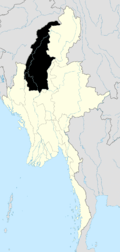 | |
| Kale District | ||
| Katha District | ||
| Mawlaik District | ||
| Monywa District | ||
| Sagaing District | ||
| Shwebo District | ||
| Tamu District | ||
| Yinmabin District | ||
| Naga Self-Administered Zone | ||