Htigyaing Township
| Htigyaing Township | |
|---|---|
| Township | |
 Htigyaing Township Location in Burma | |
| Coordinates: 23°46′0″N 96°8′0″E / 23.76667°N 96.13333°ECoordinates: 23°46′0″N 96°8′0″E / 23.76667°N 96.13333°E | |
| Country |
|
| Region | Sagaing Region |
| District | Katha District |
| Capital | Htigyaing |
| Time zone | MST (UTC+6.30) |
Htigyaing Township or Tigyaing Township is a township of Katha District in eastern Sagaing Division, in northern Burma (Myanmar). It lies on the border with the Shan State of Burma. The administrative seat is at Htigyaing.
The Shweli River, a tributary of the Irrawaddy, forms part of the northern boundary with Katha Township and part of the eastern boundary with the Shan State.[1] The Indaung Reserved Forest and the Kyauktaung Reserved Forest are located in the eastern part of the township.[1]
Among the towns and villages in Tigyaing Township are: Aledaw, Datwin, Daungbin, Htidawgaing, Myadaung, Tawma and Wundingon.
Notes
- 1 2 Army Map Service, Corps of Engineers, United States Army (1954) "Mong Mit, Burma" topographic map NF 47-1, Series U542
External links
- Township 211 on "Myanmar States/Divisions & Townships Overview Map" Myanmar Information Management Unit (MIMU)
- "Tigyaing Google Satellite Map" Maplandia.com
Capital: Htigyaing | |
|
Capital: Sagaing | ||
| Hkamti District |  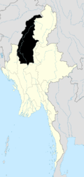 | |
| Kale District | ||
| Katha District | ||
| Mawlaik District | ||
| Monywa District | ||
| Sagaing District | ||
| Shwebo District | ||
| Tamu District | ||
| Yinmabin District | ||
| Naga Self-Administered Zone | ||
This article is issued from Wikipedia - version of the 2/4/2011. The text is available under the Creative Commons Attribution/Share Alike but additional terms may apply for the media files.