Kale Township
| Kale Township | |
|---|---|
| Township | |
 | |
 Township highlighted in the Sagaing Region | |
 Kale Township Location in Burma | |
| Coordinates: 23°11′N 94°3′E / 23.183°N 94.050°ECoordinates: 23°11′N 94°3′E / 23.183°N 94.050°E | |
| Country |
|
| Region | Sagaing Region |
| District | Kale District |
| Capital | Kalay |
| Area | |
| • Total | 2,337.74 km2 (902.61 sq mi) |
| Population (2009) | 30 Laks |
| Time zone | MST (UTC+6.30) |
Kale Township is a township in Kale District in the Sagaing Division of Burma (Myanmar). The principal town is Kalay.[1]
Geography and borders
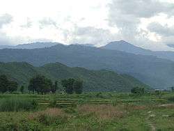
Kale Township runs north–south along the Kale Valley in which lie the south flowing Neyinzaya River and the north flowing Myittha River which meet near the administrative seat of Kalemyo and flow east toward the Chindwin River. It is bounded approximately within coordinates of 22° 36´ and 23° 38´ north latitudes and between 93° 58´ and 94° 16´ east longitudes. On the west it is bounded by the foothills of the Chin Hills and on the east by the Mwegyi Mountain Range.[2] The area of the township is 902.606 square miles (2,337.74 km2).
Kale Township is surrounded by the townships of:[1]
- Tonzang of Chin State and Mawlaik to the north;
- Kalewa and Mingin on the east;
- Gangaw to the south; and
- Hakha, Falam, Tiddim and Tonzang of Chin State to the west.
Towns and villages
Bogon, Bogyi, Chaunggyauk, Chaunggyin, Haka, Hnawgon, Honnaing, Hpaungzeik, Htoma Myauk, Inbaung, Indainggale, Indainggyi, Indin, Ingyaw, Ingyun, Insein, Inthe, Kalemyo, Kanbale, Kangyi, Kantha, Kinmungyon, Kokko, Kondo, Kyaukka, Kyaukpyok, Kyawywa, Kyetpanet, Kyigon, Lamaing, Legyi, Manda, Mawlaik, Myogyigon, Myohla, Nanhannwe, Nankyisaung, Nansaungpu, Nanzalu, Natchaung, Nat-in, Natkyigon, Natmyaung, Natnan, Ngapa, Nwa, Okkan, Palata Sakan, Pinlon, Sanmyo, Segyi, Shabo, Sibin, Sihaung Ashe, Sihaung Myauk, Sihaung Taung, Sinywa, Siyin, Taukkyan, Taung-u, Thayagon, Thayettaw, Thazi, Thekondan, Udu, Uyin, Yenatha, Yeshin, Zingalaing.
References
- 1 2 "Myanmar States/Divisions & Townships Overview Map" Myanmar Information Management Unit (MIMU)
- ↑ "1:250,000 topographic map, Series U542, Mawlaik, Burma; India, NF 46-3" U.S. Army Map Service, March 1960
External links
- "Kale Google Satellite Map" Maplandia World Gazetteer
- "Sagaing Division (Lower), Myanmar" Myanmar Information Management Unit (MIMU), map Id: MIMU270v01, creation date: 5 Aug 2010 — map showing the township boundaries
Capital: Sagaing | ||
| Hkamti District |  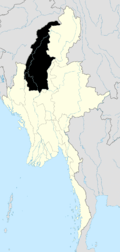 | |
| Kale District | ||
| Katha District | ||
| Mawlaik District | ||
| Monywa District | ||
| Sagaing District | ||
| Shwebo District | ||
| Tamu District | ||
| Yinmabin District | ||
| Naga Self-Administered Zone | ||