Le Roy, New York
| Le Roy | |
|---|---|
| Town | |
 | |
 Location in Genesee County and the state of New York. | |
| Coordinates: 42°58′39″N 077°59′32″W / 42.97750°N 77.99222°WCoordinates: 42°58′39″N 077°59′32″W / 42.97750°N 77.99222°W | |
| Country | United States |
| State | New York |
| County | Genesee |
| Government | |
| • Type | Town Council |
| • Town Supervisor | Steve Barbeau |
| • Town Council |
Members' List
|
| Population (2010) | |
| • Total | 7,641 |
| Time zone | Eastern (EST) (UTC-5) |
| • Summer (DST) | EDT (UTC-4) |
| Area code(s) | 14482 |
Le Roy, or more commonly LeRoy, is a town in Genesee County, New York, United States. The population was 7,641 at the 2010 census. The town is named after one of the original land owners, Herman Le Roy.[1]
The Town of Le Roy lies on the eastern edge of Genesee County. Within the town is a village also named Le Roy.
History
The town was first settled in 1793. The Town of Le Roy was established in 1812 from part of the Town of Caledonia (Livingston County) as the "Town of Bellona." The name was later changed to "Le Roy" in 1813 after New York City merchant and land speculator Herman LeRoy. Coincidentally, Capt. John Ganson, of the area that was originally named the Ganson Settlement and the Ganson Tavern, died in 1813. The Tavern was torn down by Jello-O.
Le Roy is the birthplace of Jell-O gelatin dessert. The Jell-O Museum is also located in Le Roy. General Foods closed the Jell-O factory in 1964.[2]
Le Roy was the home of Calvin Keeney, who was the first breeder to successfully produce a stringless green bean.[3]
Geography
According to the United States Census Bureau, the town has a total area of 42.2 square miles (109.2 km²), all of it land.
The east town line is the border of Monroe County and Livingston County.
Oatka Creek flows northward through the town and was a source of water power for early mills. The New York State Thruway (Interstate 90) passes across the north part of the town. The western terminus of Interstate 490 is also here.
The town rests atop the Onondaga Limestone Formation which forms an escarpment that faces north and runs east/west, just north of the village. The limestone rock is highly fossiliferous, of Devonian age, and extensively quarried. It is used for road building as crushed rock, and for the manufacture of portland cement. In the eastern part of the township is a community named Lime Rock.
Demographics
| Historical population | |||
|---|---|---|---|
| Census | Pop. | %± | |
| 1820 | 2,611 | — | |
| 1830 | 3,909 | 49.7% | |
| 1840 | 4,323 | 10.6% | |
| 1850 | 3,473 | −19.7% | |
| 1860 | 4,247 | 22.3% | |
| 1870 | 4,627 | 8.9% | |
| 1880 | 4,469 | −3.4% | |
| 1890 | 4,722 | 5.7% | |
| 1900 | 4,823 | 2.1% | |
| 1910 | 5,442 | 12.8% | |
| 1920 | 5,510 | 1.2% | |
| 1930 | 6,007 | 9.0% | |
| 1940 | 5,838 | −2.8% | |
| 1950 | 6,275 | 7.5% | |
| 1960 | 6,779 | 8.0% | |
| 1970 | 7,991 | 17.9% | |
| 1980 | 8,019 | 0.4% | |
| 1990 | 8,176 | 2.0% | |
| 2000 | 7,790 | −4.7% | |
| 2010 | 7,641 | −1.9% | |
| Est. 2014 | 7,509 | [4] | −1.7% |
As of the census[6] of 2000, there were 7,790 people, 3,037 households, and 2,034 families residing in the town. The population density was 184.7 people per square mile (71.3/km²). There were 3,219 housing units at an average density of 76.3 per square mile (29.5/km²). The racial makeup of the town was 96.01% White, 1.87% Black or African American, 0.27% Native American, 0.44% Asian, 0.01% Pacific Islander, 0.21% from other races, and 1.19% from two or more races. Hispanic or Latino of any race were 0.78% of the population.
There were 3,037 households out of which 31.9% had children under the age of 18 living with them, 52.3% were married couples living together, 9.8% had a female householder with no husband present, and 33.0% were non-families. 26.9% of all households were made up of individuals and 11.3% had someone living alone who was 65 years of age or older. The average household size was 2.49 and the average family size was 3.04.
In the town the population was spread out with 25.2% under the age of 18, 6.9% from 18 to 24, 29.4% from 25 to 44, 23.5% from 45 to 64, and 15.1% who were 65 years of age or older. The median age was 38 years. For every 100 females there were 93.0 males. For every 100 females age 18 and over, there were 89.9 males.
The median income for a household in the town was $39,690, and the median income for a family was $49,189. Males had a median income of $36,810 versus $23,024 for females. The per capita income for the town was $19,342. About 3.8% of families and 5.6% of the population were below the poverty line, including 5.0% of those under age 18 and 10.8% of those age 65 or over.
Notable people
- Seth M. Gates, former U.S. Congressman from New York[7]
Communities and locations in the town of Le Roy
- Fort Hill – A hamlet in the northwest part of the town, north of Le Roy village on Route 19. It is the site of a prehistoric Indian village.
- Le Roy – A village on Route 5 and Oatka Creek.
- Le Roy Airport (5G0) – A small general aviation airport east of the village on Route 5.
- Lime Rock – A hamlet on Route 5 near the eastern town line, east of Le Roy village.
2011 illness outbreak
Beginning in August 2011, 14 students (13 girls and 1 boy) from the LeRoy Junior-Senior High School began reporting myriad perplexing medical symptoms including verbal outbursts, tics, seizure activity and speech difficulty.[8] In mid-January, 5 days after a community meeting in which the New York State Department of Health stated their diagnosis could not be revealed publicly due to privacy concerns, two of the girls appeared on NBC's Today Show to discuss their frustration with not getting adequate answers.[9] The next day, Dr. Laszlo Mechtler, a neurologist treating most of the girls, was given permission to share the diagnosis of conversion disorder and mass psychogenic illness.
Unsatisfied with the investigation's results, the girls and their parents spoke out publicly against their diagnosis, stating they believed the situation warranted further scrutiny from outside sources. Alternative medical theories for condition were suggested, including Tourette syndrome and PANDAS, which Dr. Mechtler and his team ruled out as possibilities.[10] Erin Brockovich, noted environmental activist, was called to town to investigate environmental pollution from the 1970 Lehigh Valley Railroad derailment as a possible cause.[8][11] During this time, many of the girls appeared in the local and national media, as well as posting on social media. As this happened, many of these girls started reporting worse symptoms to their doctors and the illness spread to 20 individuals.[12]
Eventually, as doctors encouraged their patients to stay away from the media and the media attention died down, many of the girls' symptoms improved. By the end of the school year in June, one girl was diagnosed with Tourette's syndrome, likely the source of the mass psychogenic illness, and most of the girls who received treatment for conversion disorder were back to normal in time for graduation. No environmental causes were found after repeat testing around the school and surrounding areas of town.[13]
See also
References
- ↑ Gannett, Henry (1905). The Origin of Certain Place Names in the United States. U.S. Government Printing Office. p. 185.
- ↑ Belson, Ken (May 4, 2008). "Upstate, Where It Was First Made, Unwavering Devotion to Jell-O". New York Times. Retrieved July 11, 2012.
- ↑ Taylor's guide to heirloom vegetables. Boston: Houghton Mifflin. 1996. ISBN 0-395-70818-4.
- ↑ "Annual Estimates of the Resident Population for Incorporated Places: April 1, 2010 to July 1, 2014". Retrieved June 4, 2015.
- ↑ "Census of Population and Housing". Census.gov. Retrieved June 4, 2015.
- ↑ "American FactFinder". United States Census Bureau. Retrieved 2008-01-31.
- ↑ "GATES, Seth Merrill, (1800 - 1877)". Biographical Directory of the United States Congress. Retrieved March 19, 2014.
- 1 2 Steve Almasy and Jim Spellman (February 4, 2012). "N.Y. town still baffled by teens' mysterious tics". CNN. Retrieved 2012-02-04.
- ↑ Dominus, Susan (March 7, 2012). "The Mystery of 18 Twitching Teenagers in Le Roy". The New York Times.
- ↑ "Could an Infection Cause Tourette's-Like Symptoms in Teenage Girls?". Scientific American. February 2, 2012. Retrieved 2012-03-09.
- ↑ "What Really Happened To The Girls In Le Roy?". February 21, 2013. Retrieved 2013-06-25.
- ↑ "Mass Hysteria In Upstate NY", "Huffington Post", Retrieved 2012-01-31.
- ↑ "School's end clears up New York students' mystery twitching". Reuters. June 23, 2012.
External links
| Wikimedia Commons has media related to Le Roy, New York. |
- Town website
- Early history of Le Roy, NY
- Le Roy Town, Genesee County, New York Genweb Project
- Le Roy Oatkan Knights football web site
- Le Roy Airport web site
- Home of the Le Roy Marching Knights & the Instrumental, Vocal, and Drama Depts. of the Le Roy Central School
Municipalities and communities of Genesee County, New York, United States | ||
|---|---|---|
| City | 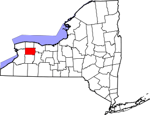 | |
| Towns | ||
| Villages | ||
| CDP |
| |
| Hamlets | ||
| Indian reservation | ||
| Footnotes | ‡This populated place also has portions in an adjacent county or counties | |
