Le Nayrac
| Le Nayrac | |
|---|---|
|
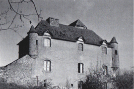
The Chateau of Freyssinet, in Nayrac | |
 Le Nayrac | |
|
Location within Occitanie region  Le Nayrac | |
| Coordinates: 44°36′50″N 2°39′50″E / 44.6139°N 2.6639°ECoordinates: 44°36′50″N 2°39′50″E / 44.6139°N 2.6639°E | |
| Country | France |
| Region | Occitanie |
| Department | Aveyron |
| Arrondissement | Rodez |
| Canton | Estaing |
| Government | |
| • Mayor (2008–2014) | Jean-Paul Turlan |
| Area1 | 36.57 km2 (14.12 sq mi) |
| Population (2008)2 | 571 |
| • Density | 16/km2 (40/sq mi) |
| Time zone | CET (UTC+1) |
| • Summer (DST) | CEST (UTC+2) |
| INSEE/Postal code | 12172 / 12190 |
| Elevation |
260–848 m (853–2,782 ft) (avg. 707 m or 2,320 ft) |
|
1 French Land Register data, which excludes lakes, ponds, glaciers > 1 km² (0.386 sq mi or 247 acres) and river estuaries. 2 Population without double counting: residents of multiple communes (e.g., students and military personnel) only counted once. | |
Le Nayrac is a commune in the Aveyron department in southern France.
Population
| Historical population | ||
|---|---|---|
| Year | Pop. | ±% |
| 1962 | 590 | — |
| 1968 | 639 | +8.3% |
| 1975 | 624 | −2.3% |
| 1982 | 660 | +5.8% |
| 1990 | 581 | −12.0% |
| 1999 | 570 | −1.9% |
| 2008 | 571 | +0.2% |
See also
References
| Wikimedia Commons has media related to Le Nayrac. |
This article is issued from Wikipedia - version of the 3/15/2016. The text is available under the Creative Commons Attribution/Share Alike but additional terms may apply for the media files.