Alrance
| Alrance | |
|---|---|
|
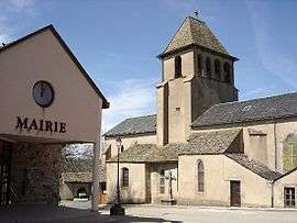
The town hall and church in Alrance | |
 Alrance | |
|
Location within Occitanie region  Alrance | |
| Coordinates: 44°07′57″N 2°41′03″E / 44.1325°N 2.6842°ECoordinates: 44°07′57″N 2°41′03″E / 44.1325°N 2.6842°E | |
| Country | France |
| Region | Occitanie |
| Department | Aveyron |
| Arrondissement | Millau |
| Canton | Salles-Curan |
| Intercommunality | Lévézou Pareloup |
| Government | |
| • Mayor (2008–2020) | Jean-Pierre Drulhe |
| Area1 | 35.43 km2 (13.68 sq mi) |
| Population (2009)2 | 404 |
| • Density | 11/km2 (30/sq mi) |
| Time zone | CET (UTC+1) |
| • Summer (DST) | CEST (UTC+2) |
| INSEE/Postal code | 12006 / 12430 |
| Elevation |
719–971 m (2,359–3,186 ft) (avg. 735 m or 2,411 ft) |
|
1 French Land Register data, which excludes lakes, ponds, glaciers > 1 km² (0.386 sq mi or 247 acres) and river estuaries. 2 Population without double counting: residents of multiple communes (e.g., students and military personnel) only counted once. | |
Alrance is a French commune in the Aveyron department in the Occitanie region of southern France.
The inhabitants of the commune are known as Alrançais or Alrançaises[1]
Geography
Alrance is located some 30 km west of Millau and about 50 km north-east of Albi. The commune can be accessed by the D56 road which runs north-east from Durenque and intersects the road D25 in the commune. It continues north through the commune to Arvieu. The D25 comes south-east from Salmiech through most of the length of the commune and continues south-east to Villefranche-de-Panat. Access to the village is from the north-east on road D659 which runs off the D577 south of the Lac de Pareloup. The D659 runs south-west and ends at the village. The D528 also runs off the D25 in the south of the commune to the village.[2]
The commune is mostly farmland with some forest and covered by many country roads. There are a number of other hamlets and villages in the commune. These are:
- L'Adrech
- Bonneguide
- Boussinesq
- Le Bouviale
- La Capelle Farcel
- La Coste
- Las Fenials
- Flauvelou
- Fretanels
- Le Jouanesq
- Lacan
- Le Mas Nespoulous
- Le Mas Viala
- Le Mas Vialet
- Montcouzac
- Nazareth
- La Niade
- Pentezac
- Peyrebrune
- La Rouquette
- Le Sales
- La Vacaresse
A number of streams rise in the commune and flow to the Lac de Villefranche-de-Panat at the southern border of the commune. The streams include L'Alrance, Ruisseau du Lagasi, and several others. Some streams rise in the north of the commune and flow northwards eventually joining Le Ceor river which eventually flows to the Viaur at Castelpers.[2]
Neighbouring communes and villages[2]
 |
Salmiech | Arvieu | Bonnevial | |
| Auriac-Lagast | |
Violon Bas | ||
| ||||
| | ||||
| Durenque | Villefranche-de-Panat | Le Vialaret |
Administration
List of Successive Mayors of Alrance[3]
| From | To | Name | Party | Position |
|---|---|---|---|---|
| 1844 | 1856 | Jean Joseph Terral | ||
| 1856 | 1860 | Adrien Seguret | ||
| 1861 | 1862 | Jean-Antoine Barthe | ||
| 1862 | 1864 | Jean-Joseph Terral | ||
| 1864 | 1870 | Jean-Antoine Barthe | ||
| 1870 | 1871 | François Gisquet | ||
| 1871 | 1878 | Joseph Gagraud | ||
| 1878 | 1916 | Adolphe Gagraud | ||
| 1916 | 1919 | Léopold Gautier | ||
| 1919 | 1934 | Adolphe Gagraud | ||
| 1934 | 1953 | Paul Serin | ||
| 1953 | 1959 | Gabriel Gintrand | ||
| 1959 | 1971 | Edouard Galtier | ||
| 1971 | 1977 | Auguste Fabre | ||
| 1977 | 2001 | Hubert Bonnefous | ||
| 2001 | 2008 | Jacques Montrozier | ||
| 2008 | 2020 | Jean-Pierre Drulhe |
(Not all data is known)
Demography
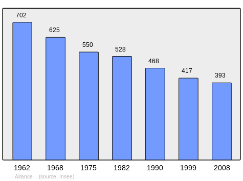
In 2009 the commune had 404 inhabitants. The evolution of the number of inhabitants is known through the population censuses conducted in the town since 1793. From the 21st century, a census of municipalities with fewer than 10,000 inhabitants is held every five years, unlike larger towns that have a sample survey every year.[Note 1]
| 1793 | 1800 | 1806 | 1821 | 1831 | 1836 | 1841 | 1846 | 1851 |
|---|---|---|---|---|---|---|---|---|
| - | - | - | - | - | - | - | 987 | 1,023 |
| 1856 | 1861 | 1866 | 1872 | 1876 | 1881 | 1886 | 1891 | 1896 |
|---|---|---|---|---|---|---|---|---|
| 990 | 992 | 942 | 974 | 906 | 994 | 998 | 892 | 854 |
| 1901 | 1906 | 1911 | 1921 | 1926 | 1931 | 1936 | 1946 | 1954 |
|---|---|---|---|---|---|---|---|---|
| 831 | 846 | 803 | 815 | 792 | 755 | 719 | 676 | 731 |
| 1962 | 1968 | 1975 | 1982 | 1990 | 1999 | 2006 | 2010 | - |
|---|---|---|---|---|---|---|---|---|
| 702 | 625 | 550 | 528 | 468 | 417 | 389 | 404 | - |
Sources : Ldh/EHESS/Cassini until 1962, INSEE database from 1968 (population without double counting and municipal population from 2006)
Sites and Monuments

- The Lac de Villefranche-de-Panat just south of the commune border provides power and water activities for the commune
- The Church of Alrance and Church of La Capelle-Farcel
- The Tower of Peyrebrune (a chapel and remains of a castle)
Notable People linked to the commune
- Jean-Baptiste Angles, a missionary in Japan.
See also
External links
- The tower of Peyrebrune in Alrance
- Alrance on Lion1906
- Alrance on Google Maps
- Alrance on Géoportail, National Geographic Institute (IGN) website (French)
- Alrance on the 1750 Cassini Map
- Alrance on the INSEE website (French)
- INSEE (French)
Notes and references
Notes
- ↑ At the beginning of the 21st century, the methods of identification have been modified by law No. 2002-276 of 27 February 2002 , the so-called "law of local democracy" and in particular Title V "census operations" which allow, after a transitional period running from 2004 to 2008, the annual publication of the legal population of the different French administrative districts. For municipalities with a population greater than 10,000 inhabitants, a sample survey is conducted annually, the entire territory of these municipalities is taken into account at the end of the period of five years. The first "legal population" after 1999 under this new law came into force on 1 January 2009 and was based on the census of 2006.
References
- ↑ Inhabitants of Aveyron (French)
- 1 2 3 Google Maps
- ↑ List of Mayors of France (French)
| Wikimedia Commons has media related to Alrance. |